Property Record
Travis & Highway 82, Sherman, TX 75092

Property Detail
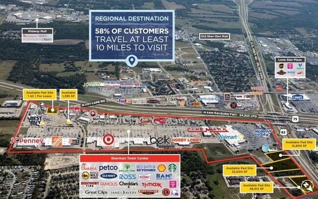
Travis & Highway 82
Sherman-Denison, TX
G-0763 MCANAIR J B, ACRES 9.816
121079
GRAYSON
Commercialacreage
Texas
AE The base floodplain where base flood elevations are provided. AE Zones are now used on new format FIRMs instead of A1-A30 Zones.
9.82 AC
2024
Sherman
2025
Other Market Areas
001101
NEARBY LISTINGS FOR SALE OR LEASE
DEMOGRAPHICS near Travis & Highway 82
1 mile
3 mile
5 mile
2025 Total Population
4,749
32,380
54,357
2030 Population
5,156
35,077
59,106
Pop Growth 2025-2030
+ 8.57%
+ 8.33%
+ 8.74%
Average Age
40
38
38
2025 Total Households
2,066
12,484
20,933
HH Growth 2025-2030
+ 8.62%
+ 8.39%
+ 8.82%
Median Household Inc
$62,476
$55,659
$58,569
Avg Household Size
2.20
2.40
2.50
2025 Avg HH Vehicles
2.00
2.00
2.00
Median Home Value
$275,543
$284,135
$260,999
Median Year Built
1990
1977
1982
Nearby Places
Map Layers
Map Styles
 Street
 Aerial
Layers
 Traffic
 Biking
Places
Listings with unknown addresses are not visible on the map
- Restaurants
- Banks
- Shops
- Fitness
- Groceries
SALE & LEASE HISTORY
LISTING DATE
SALE/LEASE

Sep 13, 2017
For Lease
Apr 19, 2022
For Sale
Nearby Properties
Address
Land Use
TOTAL SIZE
Lot Size
Zoning
Address
Land Use
TOTAL SIZE
Lot Size
Zoning
Address
Land Use
TOTAL SIZE
Lot Size
Zoning
476,941 SF
29.79 AC
Address
Land Use
TOTAL SIZE
Lot Size
Zoning
315,715 SF
24.68 AC
Address
Land Use
TOTAL SIZE
Lot Size
Zoning
304,650 SF
10.61 AC
Address
Land Use
TOTAL SIZE
Lot Size
Zoning
260,648 SF
20.20 AC
Address
Land Use
TOTAL SIZE
Lot Size
Zoning
253,076 SF
36.13 AC
Address
Land Use
TOTAL SIZE
Lot Size
Zoning
Address
Land Use
TOTAL SIZE
Lot Size
Zoning
429,486 SF
75.30 AC
Address
Land Use
TOTAL SIZE
Lot Size
Zoning
142,834 SF
9.85 AC
Address
Land Use
TOTAL SIZE
Lot Size
Zoning
61,660 SF
6.50 AC
Address
Land Use
TOTAL SIZE
Lot Size
Zoning
175,388 SF
11.46 AC
Address
Land Use
TOTAL SIZE
Lot Size
Zoning
81,100 SF
1.13 AC
Address
Land Use
TOTAL SIZE
Lot Size
Zoning
170,359 SF
9.64 AC
Address
Land Use
TOTAL SIZE
Lot Size
Zoning
136,640 SF
4.04 AC
Address
Land Use
TOTAL SIZE
Lot Size
Zoning
151,714 SF
9.13 AC
Address
Land Use
TOTAL SIZE
Lot Size
Zoning
39,850 SF
5.32 AC
Address
Land Use
TOTAL SIZE
Lot Size
Zoning
297,962 SF
51 AC
Address
Land Use
TOTAL SIZE
Lot Size
Zoning
186,834 SF
10.51 AC
Address
Land Use
TOTAL SIZE
Lot Size
Zoning
81,577 SF
9.12 AC
Address
Land Use
TOTAL SIZE
Lot Size
Zoning
316,318 SF
5.20 AC
Address
Land Use
TOTAL SIZE
Lot Size
Zoning
69,115 SF
10.52 AC
Address
Land Use
TOTAL SIZE
Lot Size
Zoning
171,840 SF
23.02 AC
Address
Land Use
TOTAL SIZE
Lot Size
Zoning
101,511 SF
4.91 AC
Address
Land Use
TOTAL SIZE
Lot Size
Zoning
160,592 SF
8.92 AC
Address
Land Use
TOTAL SIZE
Lot Size
Zoning
127,848 SF
9.60 AC
Address
Land Use
TOTAL SIZE
Lot Size
Zoning
170,455 SF
22.78 AC
Address
Land Use
TOTAL SIZE
Lot Size
Zoning
204,000 SF
21.91 AC
Address
Land Use
TOTAL SIZE
Lot Size
Zoning
137,904 SF
9.12 AC
Address
Land Use
TOTAL SIZE
Lot Size
Zoning
94,560 SF
8.74 AC
Address
Land Use
TOTAL SIZE
Lot Size
Zoning
103,742 SF
17.73 AC
The World's #1 Commercial Real Estate Marketplace
Connect with us
© 2026 CoStar Group
The information above has been obtained from sources believed reliable. While we do not doubt its accuracy we have not verified it and make no guarantee, warranty or representation about it. It is your responsibility to independently confirm its accuracy and completeness. Any projections, opinions, assumptions, or estimates used are for example only and do not represent the current or future performance of the property. The value of this transaction to you depends on tax and other factors which should be evaluated by your tax, financial, and legal advisors. You and your advisors should conduct a careful, independent investigation of the property to determine to your satisfaction the suitability of the property for your needs.