Property Record
1326 Ponder Rd, Rutherfordton, NC 28139

Property Detail
1326 Ponder Rd
P104-7
710, 710 710 COUNTY RURAL
Vacantlandnec
POLK
OPEN
North Carolina
B and X Area of moderate flood hazard, usually the area between the limits of the 100-year and 500-year floods.
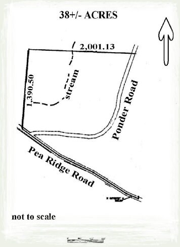
85 AC
2025
North Carolina West/Cherokee Area
2025
Other Market Areas
960501
NEARBY LISTINGS FOR SALE OR LEASE
DEMOGRAPHICS near 1326 Ponder Rd
1 mile
3 mile
5 mile
2024 Total Population
150
1,591
4,651
2029 Population
157
1,652
4,792
Pop Growth 2024-2029
+ 4.67%
+ 3.83%
+ 3.03%
Average Age
46
46
46
2024 Total Households
63
671
1,971
HH Growth 2024-2029
+ 4.76%
+ 3.87%
+ 2.99%
Median Household Inc
$46,666
$44,215
$47,809
Avg Household Size
2.30
2.40
2.30
2024 Avg HH Vehicles
2.00
2.00
2.00
Median Home Value
$316,667
$316,111
$330,454
Median Year Built
1992
1991
1991
Nearby Places
Map Layers
Map Styles
 Street
 Aerial
Transit
 Traffic
 Biking
Places
Listings with unknown addresses are not visible on the map
- Restaurants
- Banks
- Shops
- Fitness
- Groceries
PUBLIC TRANSPORTATION
AIRPORT
Asheville Regional
Drive
Walk
Distance
Asheville Regional
45 min
36.1 mi
Greenville Spartanburg International
Drive
Walk
Distance
Greenville Spartanburg International
61 min
47.7 mi
Freight Ports
North Charleston Terminal
Drive
Walk
Distance
North Charleston Terminal
256 min
228.5 mi
SALE & LEASE HISTORY
LISTING DATE
SALE/LEASE

Mar 06, 2018
For Sale
Nearby Properties
Address
Land Use
TOTAL SIZE
Lot Size
Zoning
Address
Land Use
TOTAL SIZE
Lot Size
Zoning
7,168 SF
89.29 AC
MX
Address
Land Use
TOTAL SIZE
Lot Size
Zoning
237,567 SF
23.97 AC
MX
Address
Land Use
TOTAL SIZE
Lot Size
Zoning
2,775 SF
11.01 AC
MX
Address
Land Use
TOTAL SIZE
Lot Size
Zoning
62.68 AC
Address
Land Use
TOTAL SIZE
Lot Size
Zoning
21,163 SF
53.06 AC
Address
Land Use
TOTAL SIZE
Lot Size
Zoning
1,809 SF
14.83 AC
OPEN
Address
Land Use
TOTAL SIZE
Lot Size
Zoning
227.20 AC
OPEN
Address
Land Use
TOTAL SIZE
Lot Size
Zoning
46.54 AC
Address
Land Use
TOTAL SIZE
Lot Size
Zoning
1,816 SF
56.88 AC
MX
Address
Land Use
TOTAL SIZE
Lot Size
Zoning
162.52 AC
MX
Address
Land Use
TOTAL SIZE
Lot Size
Zoning
2,440 SF
48.30 AC
OPEN
Address
Land Use
TOTAL SIZE
Lot Size
Zoning
0.89 AC
MX
Address
Land Use
TOTAL SIZE
Lot Size
Zoning
2,849 SF
49.12 AC
Address
Land Use
TOTAL SIZE
Lot Size
Zoning
2,436 SF
0.79 AC
MX
Address
Land Use
TOTAL SIZE
Lot Size
Zoning
103 AC
OPEN
Address
Land Use
TOTAL SIZE
Lot Size
Zoning
22.54 AC
OPEN
Address
Land Use
TOTAL SIZE
Lot Size
Zoning
Address
Land Use
TOTAL SIZE
Lot Size
Zoning
1,938 SF
15.98 AC
MX
Address
Land Use
TOTAL SIZE
Lot Size
Zoning
3,532 SF
3.99 AC
MX
Address
Land Use
TOTAL SIZE
Lot Size
Zoning
85.43 AC
MX
Address
Land Use
TOTAL SIZE
Lot Size
Zoning
3,160 SF
4.29 AC
MX
Address
Land Use
TOTAL SIZE
Lot Size
Zoning
1,977 SF
35.02 AC
OPEN
Address
Land Use
TOTAL SIZE
Lot Size
Zoning
67.95 AC
MX
Address
Land Use
TOTAL SIZE
Lot Size
Zoning
6,688 SF
2 AC
MX
Address
Land Use
TOTAL SIZE
Lot Size
Zoning
104 AC
OPEN
Address
Land Use
TOTAL SIZE
Lot Size
Zoning
1,376 SF
35.34 AC
MX
Address
Land Use
TOTAL SIZE
Lot Size
Zoning
4,660 SF
13.07 AC
Address
Land Use
TOTAL SIZE
Lot Size
Zoning
Address
Land Use
TOTAL SIZE
Lot Size
Zoning
3,280 SF
99.27 AC
MX
The World's #1 Commercial Real Estate Marketplace
Connect with us
© 2026 CoStar Group
The information above has been obtained from sources believed reliable. While we do not doubt its accuracy we have not verified it and make no guarantee, warranty or representation about it. It is your responsibility to independently confirm its accuracy and completeness. Any projections, opinions, assumptions, or estimates used are for example only and do not represent the current or future performance of the property. The value of this transaction to you depends on tax and other factors which should be evaluated by your tax, financial, and legal advisors. You and your advisors should conduct a careful, independent investigation of the property to determine to your satisfaction the suitability of the property for your needs.