Property Record
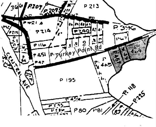
Turkey Point Rd, Edgewater, MD 21037
Property Detail
Turkey Point Rd
01-000-04417050
LT 29 PT LT 28 EDGEWATER
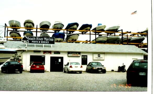
Storebuilding
ANNE ARUNDEL
MC
Maryland
AE The base floodplain where base flood elevations are provided. AE Zones are now used on new format FIRMs instead of A1-A30 Zones.
28
2024
0.39 AC
2025
Southern Anne Arundel
701201
Baltimore
3,078 SF
Baltimore-Columbia-Towson, MD
NEARBY LISTINGS FOR SALE OR LEASE
-
-
View all Edgewater listings for sale on LoopNet.com
DEMOGRAPHICS near Turkey Point Rd
1 mile
3 mile
5 mile
2025 Total Population
5,012
16,774
67,305
2030 Population
5,120
17,084
68,502
Pop Growth 2025-2030
+ 2.15%
+ 1.85%
+ 1.78%
Average Age
42
43
42
2025 Total Households
1,873
6,329
26,403
HH Growth 2025-2030
+ 2.19%
+ 1.86%
+ 1.88%
Median Household Inc
$136,450
$141,718
$118,463
Avg Household Size
2.60
2.60
2.50
2025 Avg HH Vehicles
2.00
2.00
2.00
Median Home Value
$665,473
$670,298
$563,769
Median Year Built
1981
1980
1979
Nearby Places
Map Layers
Map Styles
 Street
 Aerial
Transit
 Traffic
 Biking
Places
Listings with unknown addresses are not visible on the map
- Restaurants
- Banks
- Shops
- Fitness
- Groceries
PUBLIC TRANSPORTATION
AIRPORT
Baltimore/Washington International Thurgood Marshall
Drive
Walk
Distance
Baltimore/Washington International Thurgood Marshall
44 min
29.3 mi
Ronald Reagan Washington Ntl
Drive
Walk
Distance
Ronald Reagan Washington Ntl
56 min
34.8 mi
Freight Ports
Port of Baltimore
Drive
Walk
Distance
Port of Baltimore
51 min
34.9 mi
Nearby Properties
Address
Land Use
TOTAL SIZE
Lot Size
Zoning
Address
Land Use
TOTAL SIZE
Lot Size
Zoning
341.13 AC
R5
Address
Land Use
TOTAL SIZE
Lot Size
Zoning
15,093 SF
336.13 AC
R2
Address
Land Use
TOTAL SIZE
Lot Size
Zoning
48,572 SF
7.27 AC
R2
Address
Land Use
TOTAL SIZE
Lot Size
Zoning
55,649 SF
9.21 AC
R2
Address
Land Use
TOTAL SIZE
Lot Size
Zoning
5,498 SF
17.69 AC
MB
Address
Land Use
TOTAL SIZE
Lot Size
Zoning
10,800 SF
3.83 AC
MB
Address
Land Use
TOTAL SIZE
Lot Size
Zoning
1,760 SF
323.30 AC
OS
Address
Land Use
TOTAL SIZE
Lot Size
Zoning
1,848 SF
1.68 AC
MC
Address
Land Use
TOTAL SIZE
Lot Size
Zoning
7,706 SF
5.30 AC
MA2
Address
Land Use
TOTAL SIZE
Lot Size
Zoning
350 AC
RA
Address
Land Use
TOTAL SIZE
Lot Size
Zoning
11,237 SF
19.14 AC
R1
Address
Land Use
TOTAL SIZE
Lot Size
Zoning
26,772 SF
3.45 AC
C1B
Address
Land Use
TOTAL SIZE
Lot Size
Zoning
27,500 SF
10 AC
C4
Address
Land Use
TOTAL SIZE
Lot Size
Zoning
20,430 SF
9.81 AC
R2
Address
Land Use
TOTAL SIZE
Lot Size
Zoning
5,206 SF
1.76 AC
MC
Address
Land Use
TOTAL SIZE
Lot Size
Zoning
4,773 SF
250.90 AC
OS
Address
Land Use
TOTAL SIZE
Lot Size
Zoning
100 AC
OS
Address
Land Use
TOTAL SIZE
Lot Size
Zoning
26,400 SF
5.89 AC
C4
Address
Land Use
TOTAL SIZE
Lot Size
Zoning
12,662 SF
10.67 AC
R2
Address
Land Use
TOTAL SIZE
Lot Size
Zoning
17,008 SF
0.18 AC
R2
Address
Land Use
TOTAL SIZE
Lot Size
Zoning
13,508 SF
15 AC
R1
Address
Land Use
TOTAL SIZE
Lot Size
Zoning
8,324 SF
5.14 AC
MB
Address
Land Use
TOTAL SIZE
Lot Size
Zoning
2,240 SF
1.01 AC
MA2
Address
Land Use
TOTAL SIZE
Lot Size
Zoning
5,251 SF
0.22 AC
R2
Address
Land Use
TOTAL SIZE
Lot Size
Zoning
4,854 SF
2.61 AC
MA3
Address
Land Use
TOTAL SIZE
Lot Size
Zoning
280 SF
2.04 AC
R2
Address
Land Use
TOTAL SIZE
Lot Size
Zoning
3,600 SF
3.79 AC
MB
Address
Land Use
TOTAL SIZE
Lot Size
Zoning
160 SF
1.61 AC
MA2
Address
Land Use
TOTAL SIZE
Lot Size
Zoning
20,158 SF
3.72 AC
MB
Address
Land Use
TOTAL SIZE
Lot Size
Zoning
4,446 SF
0.50 AC
R5
The World's #1 Commercial Real Estate Marketplace
Connect with us
© 2026 CoStar Group
The information above has been obtained from sources believed reliable. While we do not doubt its accuracy we have not verified it and make no guarantee, warranty or representation about it. It is your responsibility to independently confirm its accuracy and completeness. Any projections, opinions, assumptions, or estimates used are for example only and do not represent the current or future performance of the property. The value of this transaction to you depends on tax and other factors which should be evaluated by your tax, financial, and legal advisors. You and your advisors should conduct a careful, independent investigation of the property to determine to your satisfaction the suitability of the property for your needs.