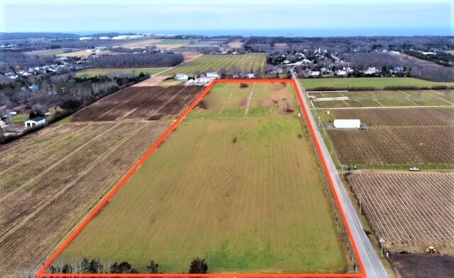
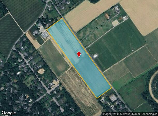
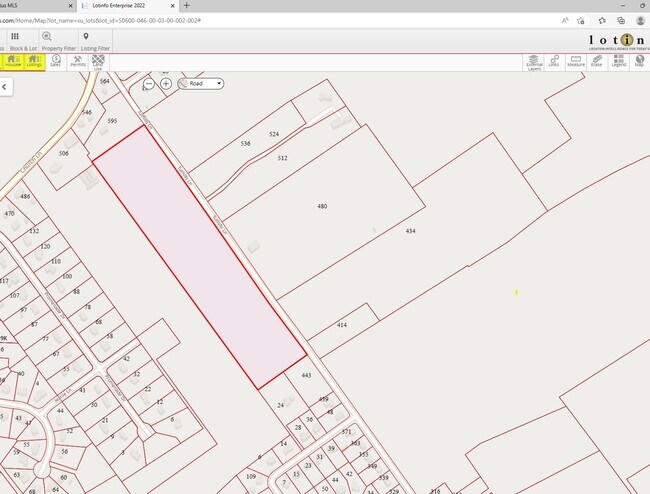
Property Record
Tuthills Ln, Jamesport, NY 11947
NEARBY LISTINGS FOR SALE OR LEASE
Property Detail
Tuthills Ln
Nassau County-Suffolk County, NY
SUFF CO DEV RTS PCL I-6 NX SPRINGER EX TUTHILS LASX LILCO & ANO W X STAKEY
0600-046-00-01-00-040-001
Suffolk
Agriculturalland
New York
X
40
36103C0478H
19.10 AC
2024
Eastern Suffolk
2024
Long Island (New York)
169905
DEMOGRAPHICS near Tuthills Ln
1 Mile
3 Mile
5 Mile
2024 Total Population
845
8,202
33,311
2029 Population
817
7,997
33,201
Pop Growth 2024-2029
(3.31%)
(2.50%)
(0.33%)
Average Age
46
44
42
2024 Total Households
318
2,992
11,931
HH Growth 2024-2029
(3.46%)
(3.04%)
(0.55%)
Median Household Inc
$121,323
$107,506
$80,087
Avg Household Size
2.60
2.60
2.60
2024 Avg HH Vehicles
3.00
2.00
2.00
Median Home Value
$742,283
$650,758
$488,597
Median Year Built
1987
1981
1981
Nearby Places
- Restaurants
- Banks
- Shops
- Fitness
- Groceries
PUBLIC TRANSPORTATION
COMMUTER RAIL
Riverhead Station (Greenport Branch - Long Island Rail Road)
DRIVE
WALK
Distance
Riverhead Station (Greenport Branch - Long Island Rail Road)
11 min
5.2 mi
Mattituck Station (Greenport Branch - Long Island Rail Road)
DRIVE
WALK
Distance
Mattituck Station (Greenport Branch - Long Island Rail Road)
9 min
5.4 mi
AIRPORT
Long Island MacArthur
DRIVE
WALK
Distance
Long Island MacArthur
53 min
33.8 mi
Freight Ports
Port of New Haven
DRIVE
WALK
Distance
Port of New Haven
152 min
62.6 mi
SALE & LEASE HISTORY
LISTING DATE
SALE/LEASE

Jan 16, 2023
For Sale
Nearby Properties
Address
Land Use
TOTAL SIZE
Lot Size
Zoning
Address
Land Use
TOTAL SIZE
Lot Size
Zoning
214.30 AC
10
Address
Land Use
TOTAL SIZE
Lot Size
Zoning
113,634 SF
27.49 AC
04
Address
Land Use
TOTAL SIZE
Lot Size
Zoning
14,520 SF
21.20 AC
04
Address
Land Use
TOTAL SIZE
Lot Size
Zoning
274.40 AC
05
Address
Land Use
TOTAL SIZE
Lot Size
Zoning
29.93 AC
RA80
Address
Land Use
TOTAL SIZE
Lot Size
Zoning
149.95 AC
APZ
Address
Land Use
TOTAL SIZE
Lot Size
Zoning
11,000 SF
182 AC
01
Address
Land Use
TOTAL SIZE
Lot Size
Zoning
1,688 SF
34.47 AC
09
Address
Land Use
TOTAL SIZE
Lot Size
Zoning
66,307 SF
11.09 AC
03
Address
Land Use
TOTAL SIZE
Lot Size
Zoning
3.80 AC
CRC
Address
Land Use
TOTAL SIZE
Lot Size
Zoning
5.47 AC
04
Address
Land Use
TOTAL SIZE
Lot Size
Zoning
5.01 AC
10
Address
Land Use
TOTAL SIZE
Lot Size
Zoning
227.20 AC
04
Address
Land Use
TOTAL SIZE
Lot Size
Zoning
20.60 AC
APZ
Address
Land Use
TOTAL SIZE
Lot Size
Zoning
19,494 SF
65.80 AC
4
Address
Land Use
TOTAL SIZE
Lot Size
Zoning
2,137 SF
9.73 AC
04 - FARM
Address
Land Use
TOTAL SIZE
Lot Size
Zoning
19.63 AC
RA80
Address
Land Use
TOTAL SIZE
Lot Size
Zoning
155.90 AC
01
Address
Land Use
TOTAL SIZE
Lot Size
Zoning
4,092 SF
5.21 AC
03
Address
Land Use
TOTAL SIZE
Lot Size
Zoning
15,996 SF
6.05 AC
3
Address
Land Use
TOTAL SIZE
Lot Size
Zoning
5,338 SF
159.30 AC
4
Address
Land Use
TOTAL SIZE
Lot Size
Zoning
1,154 SF
1.71 AC
10
Address
Land Use
TOTAL SIZE
Lot Size
Zoning
172.90 AC
RA80
Address
Land Use
TOTAL SIZE
Lot Size
Zoning
94.60 AC
04
Address
Land Use
TOTAL SIZE
Lot Size
Zoning
3,422 SF
112.20 AC
01
Address
Land Use
TOTAL SIZE
Lot Size
Zoning
2,600 SF
27.30 AC
RB80
Address
Land Use
TOTAL SIZE
Lot Size
Zoning
1.28 AC
R40
Address
Land Use
TOTAL SIZE
Lot Size
Zoning
11.39 AC
10
Address
Land Use
TOTAL SIZE
Lot Size
Zoning
1,980 SF
63.11 AC
09
Address
Land Use
TOTAL SIZE
Lot Size
Zoning
38 AC
03
The World's #1 Commercial Real Estate Marketplace
Connect with us
© 2025 CoStar Group
The information above has been obtained from sources believed reliable. While we do not doubt its accuracy we have not verified it and make no guarantee, warranty or representation about it. It is your responsibility to independently confirm its accuracy and completeness. Any projections, opinions, assumptions, or estimates used are for example only and do not represent the current or future performance of the property. The value of this transaction to you depends on tax and other factors which should be evaluated by your tax, financial, and legal advisors. You and your advisors should conduct a careful, independent investigation of the property to determine to your satisfaction the suitability of the property for your needs.