Property Record
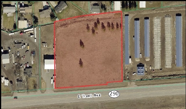
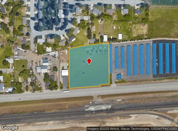
Unassigned Address, Spokane Valley, WA 99027

Current Lease Availabilities
NEARBY LISTINGS FOR SALE OR LEASE
Property Detail
Unassigned Address
45011.9045
01-25-44 PTN OF NE1/4 DAF; E362 OF W1535 LYG S OF N LN OF VAC CANAL & NLY OF CPH #33 EXC RD
Wholesaleoutletdiscountstore
Spokane
X
Washington
53063C0585D
3.11 AC
2025
Valley
2025
Spokane
013201
Spokane-Spokane Valley, WA
17,946 SF
DEMOGRAPHICS near Unassigned Address
1 Mile
3 Mile
5 Mile
2024 Total Population
1,442
36,263
101,723
2029 Population
1,524
39,269
108,995
Pop Growth 2024-2029
+ 5.69%
+ 8.29%
+ 7.15%
Average Age
43
39
40
2024 Total Households
568
14,974
40,851
HH Growth 2024-2029
+ 5.99%
+ 8.41%
+ 7.32%
Median Household Inc
$57,672
$62,591
$66,970
Avg Household Size
2.50
2.40
2.40
2024 Avg HH Vehicles
3.00
2.00
2.00
Median Home Value
$371,353
$348,476
$363,791
Median Year Built
1976
1995
1990
Nearby Places
Map Layers
Map Styles
 Street
 Aerial
- Restaurants
- Banks
- Shops
- Fitness
- Groceries
PUBLIC TRANSPORTATION
AIRPORT
Spokane International
DRIVE
WALK
Distance
Spokane International
27 min
18.4 mi
Freight Ports
Port of Everett
DRIVE
WALK
Distance
Port of Everett
355 min
314.0 mi
Nearby Properties
Address
Land Use
TOTAL SIZE
Lot Size
Zoning
Address
Land Use
TOTAL SIZE
Lot Size
Zoning
2,818,475 SF
466.05 AC
I-2
Address
Land Use
TOTAL SIZE
Lot Size
Zoning
1,326,772 SF
85.91 AC
I-2
Address
Land Use
TOTAL SIZE
Lot Size
Zoning
373,111 SF
12.44 AC
MUC
Address
Land Use
TOTAL SIZE
Lot Size
Zoning
130,380 SF
11.10 AC
MUC
Address
Land Use
TOTAL SIZE
Lot Size
Zoning
3,688,247 SF
244.85 AC
I-2
Address
Land Use
TOTAL SIZE
Lot Size
Zoning
296,760 SF
37.61 AC
I-1
Address
Land Use
TOTAL SIZE
Lot Size
Zoning
169,003 SF
5.18 AC
MUC
Address
Land Use
TOTAL SIZE
Lot Size
Zoning
270,453 SF
28.62 AC
Address
Land Use
TOTAL SIZE
Lot Size
Zoning
259,169 SF
13.42 AC
MF-2
Address
Land Use
TOTAL SIZE
Lot Size
Zoning
216,965 SF
10.70 AC
MUC
Address
Land Use
TOTAL SIZE
Lot Size
Zoning
227,044 SF
7.20 AC
MUC
Address
Land Use
TOTAL SIZE
Lot Size
Zoning
318,756 SF
13.64 AC
MF-2
Address
Land Use
TOTAL SIZE
Lot Size
Zoning
98,088 SF
13.94 AC
SAP
Address
Land Use
TOTAL SIZE
Lot Size
Zoning
323,993 SF
10.97 AC
MUC
Address
Land Use
TOTAL SIZE
Lot Size
Zoning
197,868 SF
7.15 AC
MUC
Address
Land Use
TOTAL SIZE
Lot Size
Zoning
192,698 SF
9.55 AC
MUC
Address
Land Use
TOTAL SIZE
Lot Size
Zoning
346,589 SF
16.28 AC
MF-2
Address
Land Use
TOTAL SIZE
Lot Size
Zoning
204,730 SF
8.60 AC
MUC
Address
Land Use
TOTAL SIZE
Lot Size
Zoning
123,400 SF
4.50 AC
MUC
Address
Land Use
TOTAL SIZE
Lot Size
Zoning
211,011 SF
8.81 AC
CMU
Address
Land Use
TOTAL SIZE
Lot Size
Zoning
139,122 SF
6.17 AC
MUC
Address
Land Use
TOTAL SIZE
Lot Size
Zoning
138,379 SF
17.39 AC
RC
Address
Land Use
TOTAL SIZE
Lot Size
Zoning
68,928 SF
10.96 AC
R-3
Address
Land Use
TOTAL SIZE
Lot Size
Zoning
231,172 SF
19.20 AC
RC
Address
Land Use
TOTAL SIZE
Lot Size
Zoning
144,544 SF
9.65 AC
I-1
Address
Land Use
TOTAL SIZE
Lot Size
Zoning
152,033 SF
6.14 AC
MF-2
Address
Land Use
TOTAL SIZE
Lot Size
Zoning
144,349 SF
8.06 AC
I-2
Address
Land Use
TOTAL SIZE
Lot Size
Zoning
151,690 SF
7.89 AC
MF-2
Address
Land Use
TOTAL SIZE
Lot Size
Zoning
126,989 SF
7.55 AC
I-2
Address
Land Use
TOTAL SIZE
Lot Size
Zoning
61,059 SF
54.20 AC
P/OS
The World's #1 Commercial Real Estate Marketplace
Connect with us
© 2025 CoStar Group
The information above has been obtained from sources believed reliable. While we do not doubt its accuracy we have not verified it and make no guarantee, warranty or representation about it. It is your responsibility to independently confirm its accuracy and completeness. Any projections, opinions, assumptions, or estimates used are for example only and do not represent the current or future performance of the property. The value of this transaction to you depends on tax and other factors which should be evaluated by your tax, financial, and legal advisors. You and your advisors should conduct a careful, independent investigation of the property to determine to your satisfaction the suitability of the property for your needs.