Property Record
Unassigned Location Re, Hawthorne, FL 32640

Save to a Folder
{{folder.Name}}
{{folder.ListingIds.length}} Properties
{{folder.ListingIds.length}} Property
Create a New Folder
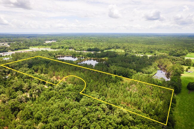
Property Detail
Unassigned Location Re
19303-002-012
COM NE COR OF NW1/4 OF SW1/4 S 01 DEG 31 MIN 22 SEC E 10 FT S 87 DEG 07 MIN 20 SEC W 19.31 FT TO W R/W SE 223RD ST POB S 87 DEG 07 MIN 20 SEC W 546.21 FT S 03 DEG 09 MIN 33 SEC E 750.70 FT N 86 DEG 50 MIN 27 SEC E 256.63 FT NELY ALG CURVE 132.40 FT N
Commercialacreage
ALACHUA
RMF2
Florida
B and X Area of moderate flood hazard, usually the area between the limits of the 100-year and 500-year floods.
8.82 AC
2025
Gainesville
2025
Other Market Areas
002002
Gainesville, FL
NEARBY LISTINGS FOR SALE OR LEASE
DEMOGRAPHICS near Unassigned Location Re
1 mile
3 mile
5 mile
2025 Total Population
876
2,451
5,990
2030 Population
914
2,594
6,390
Pop Growth 2025-2030
+ 4.34%
+ 5.83%
+ 6.68%
Average Age
40
43
45
2025 Total Households
330
968
2,482
HH Growth 2025-2030
+ 5.15%
+ 6.61%
+ 7.25%
Median Household Inc
$59,431
$54,210
$54,345
Avg Household Size
2.70
2.50
2.40
2025 Avg HH Vehicles
2.00
2.00
2.00
Median Home Value
$139,719
$155,252
$168,728
Median Year Built
1974
1979
1984
Nearby Places
Map Layers
Map Styles
 Street
 Aerial
Layers
 Traffic
 Biking
Places
Listings with unknown addresses are not visible on the map
- Restaurants
- Banks
- Shops
- Fitness
- Groceries
PUBLIC TRANSPORTATION
AIRPORT
Gainesville Regional
Drive
Walk
Distance
Gainesville Regional
29 min
19.0 mi
Freight Ports
Jacksonville Port
Drive
Walk
Distance
Jacksonville Port
97 min
75.7 mi
SALE & LEASE HISTORY
LISTING DATE
SALE/LEASE

Jun 14, 2018
For Sale
Nearby Properties
Address
Land Use
TOTAL SIZE
Lot Size
Zoning
Address
Land Use
TOTAL SIZE
Lot Size
Zoning
411,296 SF
31.62 AC
RSF2
Address
Land Use
TOTAL SIZE
Lot Size
Zoning
52,762 SF
8.47 AC
RSF2
Address
Land Use
TOTAL SIZE
Lot Size
Zoning
55,849 SF
7.74 AC
CG
Address
Land Use
TOTAL SIZE
Lot Size
Zoning
10,854 SF
5.22 AC
CIW
Address
Land Use
TOTAL SIZE
Lot Size
Zoning
21,156 SF
5.86 AC
CG
Address
Land Use
TOTAL SIZE
Lot Size
Zoning
20,258 SF
10.13 AC
RSF2
Address
Land Use
TOTAL SIZE
Lot Size
Zoning
11,986 SF
1.59 AC
CG
Address
Land Use
TOTAL SIZE
Lot Size
Zoning
21,000 SF
1.80 AC
CIW
Address
Land Use
TOTAL SIZE
Lot Size
Zoning
1,613 SF
39.70 AC
A
Address
Land Use
TOTAL SIZE
Lot Size
Zoning
17,760 SF
1.34 AC
RSF2
Address
Land Use
TOTAL SIZE
Lot Size
Zoning
19,180 SF
2.13 AC
I
Address
Land Use
TOTAL SIZE
Lot Size
Zoning
2,315 SF
6.38 AC
RSF2
Address
Land Use
TOTAL SIZE
Lot Size
Zoning
4,636 SF
0.31 AC
CG
Address
Land Use
TOTAL SIZE
Lot Size
Zoning
11,732 SF
1.49 AC
A
Address
Land Use
TOTAL SIZE
Lot Size
Zoning
4,929 SF
2.52 AC
CG
Address
Land Use
TOTAL SIZE
Lot Size
Zoning
6,060 SF
9.97 AC
I
Address
Land Use
TOTAL SIZE
Lot Size
Zoning
5,520 SF
0.55 AC
CCBD
Address
Land Use
TOTAL SIZE
Lot Size
Zoning
8,804 SF
0.68 AC
RSF1
Address
Land Use
TOTAL SIZE
Lot Size
Zoning
12,000 SF
5.16 AC
CIW
Address
Land Use
TOTAL SIZE
Lot Size
Zoning
3,200 SF
34.51 AC
A
Address
Land Use
TOTAL SIZE
Lot Size
Zoning
4,963 SF
0.65 AC
IL
Address
Land Use
TOTAL SIZE
Lot Size
Zoning
5,550 SF
40.45 AC
A
Address
Land Use
TOTAL SIZE
Lot Size
Zoning
5,041 SF
0.45 AC
CCBD
Address
Land Use
TOTAL SIZE
Lot Size
Zoning
10,716 SF
1.13 AC
CG
Address
Land Use
TOTAL SIZE
Lot Size
Zoning
4,137 SF
5 AC
A
Address
Land Use
TOTAL SIZE
Lot Size
Zoning
9,443 SF
1.36 AC
RMF1
Address
Land Use
TOTAL SIZE
Lot Size
Zoning
6,352 SF
0.87 AC
CCBD
Address
Land Use
TOTAL SIZE
Lot Size
Zoning
6,936 SF
0.95 AC
CG
Address
Land Use
TOTAL SIZE
Lot Size
Zoning
3,560 SF
1.72 AC
CIW
Address
Land Use
TOTAL SIZE
Lot Size
Zoning
2,718 SF
10.15 AC
A
The World's #1 Commercial Real Estate Marketplace
Connect with us
© 2026 CoStar Group
The information above has been obtained from sources believed reliable. While we do not doubt its accuracy we have not verified it and make no guarantee, warranty or representation about it. It is your responsibility to independently confirm its accuracy and completeness. Any projections, opinions, assumptions, or estimates used are for example only and do not represent the current or future performance of the property. The value of this transaction to you depends on tax and other factors which should be evaluated by your tax, financial, and legal advisors. You and your advisors should conduct a careful, independent investigation of the property to determine to your satisfaction the suitability of the property for your needs.