Property Record
Unassigned, Monroe, OR 97456

Property Detail
Unassigned
Corvallis, OR
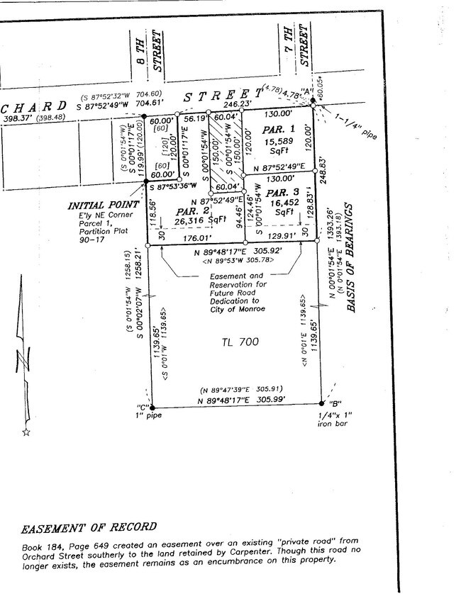
LOT 3
388641
BENTON
Residentialacreage
Oregon
GRA
3
B and X Area of moderate flood hazard, usually the area between the limits of the 100-year and 500-year floods.
0.38 AC
2025
Oregon West Area
2025
Other Market Areas
010400
NEARBY LISTINGS FOR SALE OR LEASE
-
-
View all Monroe listings for sale on LoopNet.com
DEMOGRAPHICS near Unassigned
1 mile
3 mile
5 mile
2025 Total Population
1,303
1,979
3,287
2030 Population
1,327
2,016
3,345
Pop Growth 2025-2030
+ 1.84%
+ 1.87%
+ 1.76%
Average Age
45
45
46
2025 Total Households
489
744
1,245
HH Growth 2025-2030
+ 1.84%
+ 1.88%
+ 1.69%
Median Household Inc
$72,783
$72,538
$73,318
Avg Household Size
2.60
2.60
2.60
2025 Avg HH Vehicles
2.00
2.00
2.00
Median Home Value
$523,809
$512,500
$539,216
Median Year Built
1978
1978
1977
Nearby Places
Map Layers
Map Styles
 Street
 Aerial
Layers
 Traffic
 Biking
Places
Listings with unknown addresses are not visible on the map
- Restaurants
- Banks
- Shops
- Fitness
- Groceries
PUBLIC TRANSPORTATION
AIRPORT
Mahlon Sweet Field
Drive
Walk
Distance
Mahlon Sweet Field
30 min
18.4 mi
Nearby Properties
Address
Land Use
TOTAL SIZE
Lot Size
Zoning
Address
Land Use
TOTAL SIZE
Lot Size
Zoning
Address
Land Use
TOTAL SIZE
Lot Size
Zoning
Address
Land Use
TOTAL SIZE
Lot Size
Zoning
18,220 SF
5 AC
FC
Address
Land Use
TOTAL SIZE
Lot Size
Zoning
17,828 SF
Address
Land Use
TOTAL SIZE
Lot Size
Zoning
Address
Land Use
TOTAL SIZE
Lot Size
Zoning
Address
Land Use
TOTAL SIZE
Lot Size
Zoning
Address
Land Use
TOTAL SIZE
Lot Size
Zoning
6,512 SF
11.90 AC
RR-2
Address
Land Use
TOTAL SIZE
Lot Size
Zoning
Address
Land Use
TOTAL SIZE
Lot Size
Zoning
2,420 SF
146.23 AC
EFU
Address
Land Use
TOTAL SIZE
Lot Size
Zoning
15,511 SF
0.36 AC
C
Address
Land Use
TOTAL SIZE
Lot Size
Zoning
4,263 SF
110.19 AC
EFU
Address
Land Use
TOTAL SIZE
Lot Size
Zoning
Address
Land Use
TOTAL SIZE
Lot Size
Zoning
Address
Land Use
TOTAL SIZE
Lot Size
Zoning
Address
Land Use
TOTAL SIZE
Lot Size
Zoning
4,019 SF
2.56 AC
EFU
Address
Land Use
TOTAL SIZE
Lot Size
Zoning
15,040 SF
0.62 AC
C
Address
Land Use
TOTAL SIZE
Lot Size
Zoning
3,252 SF
2.98 AC
EFU
Address
Land Use
TOTAL SIZE
Lot Size
Zoning
1,887 SF
391.48 AC
EFU
Address
Land Use
TOTAL SIZE
Lot Size
Zoning
Address
Land Use
TOTAL SIZE
Lot Size
Zoning
64 AC
E40
Address
Land Use
TOTAL SIZE
Lot Size
Zoning
11,324 SF
0.82 AC
GRB
Address
Land Use
TOTAL SIZE
Lot Size
Zoning
7,008 SF
31 AC
EFU
Address
Land Use
TOTAL SIZE
Lot Size
Zoning
Address
Land Use
TOTAL SIZE
Lot Size
Zoning
5,632 SF
42.74 AC
E40
Address
Land Use
TOTAL SIZE
Lot Size
Zoning
12,828 SF
Address
Land Use
TOTAL SIZE
Lot Size
Zoning
5,132 SF
267.54 AC
EFU
Address
Land Use
TOTAL SIZE
Lot Size
Zoning
5,404 SF
100.34 AC
EFU
Address
Land Use
TOTAL SIZE
Lot Size
Zoning
13,884 SF
2.49 AC
M
Address
Land Use
TOTAL SIZE
Lot Size
Zoning
4,921 SF
51.78 AC
EFU
The World's #1 Commercial Real Estate Marketplace
Connect with us
© 2026 CoStar Group
The information above has been obtained from sources believed reliable. While we do not doubt its accuracy we have not verified it and make no guarantee, warranty or representation about it. It is your responsibility to independently confirm its accuracy and completeness. Any projections, opinions, assumptions, or estimates used are for example only and do not represent the current or future performance of the property. The value of this transaction to you depends on tax and other factors which should be evaluated by your tax, financial, and legal advisors. You and your advisors should conduct a careful, independent investigation of the property to determine to your satisfaction the suitability of the property for your needs.