Property Record
Undetermined, Kennewick, WA 99338
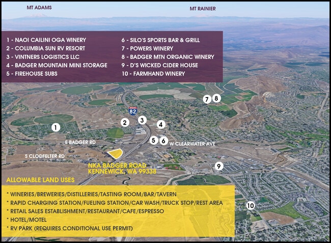


This Property Is For Sale
Property Detail
Undetermined
Kennewick-Richland, WA
ALL THAT PORTION OF THE FOLLOWING DESCRIBED PARCEL LYING SOUTHERLY OF SR-I82 RIGHT OF WAY: THE NORTH HALF OF THE SOUTHWEST QUARTER OF SECTION 12, TOWNSHIP 8 NORTH, RANGE 28 AND THE NORTH HALF OF THE NORTH HALF OF THE SOUTH HALF OF OF THE SOUTHWEST
112883000002002
BENTON
Vacantlandnec
Washington
2025
8.33 AC
2025
Yakima/Kennewick
010813
Other Market Areas
NEARBY LISTINGS FOR SALE OR LEASE
-
-
-
-
-
-
-
NWC OF W Clearwater & N Columbia Center Blvd
Kennewick, WA 99336
Rent Upon Request
2.14 AC Lots
Land
-
View all Kennewick listings for sale on LoopNet.com
DEMOGRAPHICS near Undetermined
1 mile
3 mile
5 mile
2025 Total Population
2,841
37,151
85,931
2030 Population
3,047
38,971
89,989
Pop Growth 2025-2030
+ 7.25%
+ 4.90%
+ 4.72%
Average Age
35
39
39
2025 Total Households
1,045
14,262
32,484
HH Growth 2025-2030
+ 7.37%
+ 4.82%
+ 4.70%
Median Household Inc
$94,629
$96,962
$89,890
Avg Household Size
2.70
2.60
2.60
2025 Avg HH Vehicles
2.00
2.00
2.00
Median Home Value
$659,904
$496,483
$488,710
Median Year Built
2011
2002
1997
Nearby Places
Map Layers
Map Styles
 Street
 Aerial
Layers
 Traffic
 Biking
Places
Listings with unknown addresses are not visible on the map
- Restaurants
- Banks
- Shops
- Fitness
- Groceries
PUBLIC TRANSPORTATION
AIRPORT
Tri-Cities
Drive
Walk
Distance
Tri-Cities
20 min
13.0 mi
Freight Ports
Port of Tacoma
Drive
Walk
Distance
Port of Tacoma
275 min
240.5 mi
Nearby Properties
Address
Land Use
TOTAL SIZE
Lot Size
Zoning
Address
Land Use
TOTAL SIZE
Lot Size
Zoning
614,021 SF
45.64 AC
Address
Land Use
TOTAL SIZE
Lot Size
Zoning
340,554 SF
16.21 AC
RICHLAND -
Address
Land Use
TOTAL SIZE
Lot Size
Zoning
248,623 SF
12 AC
Address
Land Use
TOTAL SIZE
Lot Size
Zoning
223,214 SF
17.06 AC
Address
Land Use
TOTAL SIZE
Lot Size
Zoning
179,139 SF
11.79 AC
Address
Land Use
TOTAL SIZE
Lot Size
Zoning
181,666 SF
12.29 AC
35
Address
Land Use
TOTAL SIZE
Lot Size
Zoning
168,652 SF
10.43 AC
KENNEWICK
Address
Land Use
TOTAL SIZE
Lot Size
Zoning
206,208 SF
10.01 AC
KENNEWICK
Address
Land Use
TOTAL SIZE
Lot Size
Zoning
82,470 SF
14.49 AC
Address
Land Use
TOTAL SIZE
Lot Size
Zoning
127,840 SF
3.69 AC
Address
Land Use
TOTAL SIZE
Lot Size
Zoning
200,734 SF
12.38 AC
Address
Land Use
TOTAL SIZE
Lot Size
Zoning
126,589 SF
4.05 AC
Address
Land Use
TOTAL SIZE
Lot Size
Zoning
80,622 SF
26.90 AC
Address
Land Use
TOTAL SIZE
Lot Size
Zoning
66,035 SF
15.38 AC
Address
Land Use
TOTAL SIZE
Lot Size
Zoning
157,320 SF
3.80 AC
53
Address
Land Use
TOTAL SIZE
Lot Size
Zoning
93,851 SF
1.05 AC
Address
Land Use
TOTAL SIZE
Lot Size
Zoning
78,836 SF
13.64 AC
Address
Land Use
TOTAL SIZE
Lot Size
Zoning
74,556 SF
1.22 AC
Address
Land Use
TOTAL SIZE
Lot Size
Zoning
76,028 SF
1.83 AC
Address
Land Use
TOTAL SIZE
Lot Size
Zoning
137,322 SF
10.63 AC
Address
Land Use
TOTAL SIZE
Lot Size
Zoning
Address
Land Use
TOTAL SIZE
Lot Size
Zoning
154,818 SF
16.84 AC
KENNEWICK
Address
Land Use
TOTAL SIZE
Lot Size
Zoning
140,398 SF
5.17 AC
RICHLAND -
Address
Land Use
TOTAL SIZE
Lot Size
Zoning
108,351 SF
4.84 AC
KENNEWICK
Address
Land Use
TOTAL SIZE
Lot Size
Zoning
76,834 SF
7.32 AC
58
Address
Land Use
TOTAL SIZE
Lot Size
Zoning
Address
Land Use
TOTAL SIZE
Lot Size
Zoning
10,311 SF
10.41 AC
KENNEWICK
Address
Land Use
TOTAL SIZE
Lot Size
Zoning
51,058 SF
3.77 AC
RICHLAND -
Address
Land Use
TOTAL SIZE
Lot Size
Zoning
15,757 SF
10.73 AC
Address
Land Use
TOTAL SIZE
Lot Size
Zoning
91,402 SF
7.20 AC
The World's #1 Commercial Real Estate Marketplace
Connect with us
© 2026 CoStar Group
The information above has been obtained from sources believed reliable. While we do not doubt its accuracy we have not verified it and make no guarantee, warranty or representation about it. It is your responsibility to independently confirm its accuracy and completeness. Any projections, opinions, assumptions, or estimates used are for example only and do not represent the current or future performance of the property. The value of this transaction to you depends on tax and other factors which should be evaluated by your tax, financial, and legal advisors. You and your advisors should conduct a careful, independent investigation of the property to determine to your satisfaction the suitability of the property for your needs.