Property Record
4801 Sibley Dr, Bismarck, ND 58504
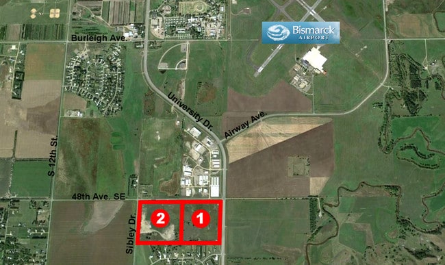
This Property Is For Sale
NEARBY LISTINGS FOR SALE OR LEASE
Property Detail
4801 Sibley Dr
Bismarck, ND
Lincoln
38-138-80-00-27-200
TWN: 138 SCT: 27 RNG: 80 SUB: 381388000 LINCOLN TOWNSHIP SECTION 27 NW1/4NE1/4 673723 27-138-80
Vacantlandnec
Burleigh
X
North Dakota
38015C0960E
40 AC
2024
South Bismarck
2024
Other Market Areas
011300
DEMOGRAPHICS near 4801 Sibley Dr
1 Mile
3 Mile
5 Mile
2024 Total Population
609
15,817
46,878
2029 Population
620
16,157
48,175
Pop Growth 2024-2029
+ 1.81%
+ 2.15%
+ 2.77%
Average Age
34
36
39
2024 Total Households
136
5,858
19,461
HH Growth 2024-2029
+ 2.21%
+ 2.17%
+ 2.92%
Median Household Inc
$94,921
$75,490
$60,415
Avg Household Size
2.60
2.50
2.20
2024 Avg HH Vehicles
2.00
2.00
2.00
Median Home Value
$301,852
$253,309
$243,881
Median Year Built
1989
1995
1977
Nearby Places
Map Layers
Map Styles
 Street
 Aerial
- Restaurants
- Banks
- Shops
- Fitness
- Groceries
PUBLIC TRANSPORTATION
AIRPORT
Bismarck Municipal
DRIVE
WALK
Distance
Bismarck Municipal
16 min
5.6 mi
Freight Ports
Port Milwaukee
DRIVE
WALK
Distance
Port Milwaukee
831 min
768.9 mi
Nearby Properties
Address
Land Use
TOTAL SIZE
Lot Size
Zoning
Address
Land Use
TOTAL SIZE
Lot Size
Zoning
26.42 AC
MA
Address
Land Use
TOTAL SIZE
Lot Size
Zoning
35.42 AC
MA
Address
Land Use
TOTAL SIZE
Lot Size
Zoning
60,105 SF
11.86 AC
RM30
Address
Land Use
TOTAL SIZE
Lot Size
Zoning
44,652 SF
13.84 AC
RM30
Address
Land Use
TOTAL SIZE
Lot Size
Zoning
6.29 AC
RM30
Address
Land Use
TOTAL SIZE
Lot Size
Zoning
20.41 AC
MA
Address
Land Use
TOTAL SIZE
Lot Size
Zoning
14.22 AC
MA
Address
Land Use
TOTAL SIZE
Lot Size
Zoning
42,908 SF
12.44 AC
MA
Address
Land Use
TOTAL SIZE
Lot Size
Zoning
81.73 AC
RMH
Address
Land Use
TOTAL SIZE
Lot Size
Zoning
Address
Land Use
TOTAL SIZE
Lot Size
Zoning
92,982 SF
3.80 AC
RM30
Address
Land Use
TOTAL SIZE
Lot Size
Zoning
87,783 SF
3.86 AC
RM30
Address
Land Use
TOTAL SIZE
Lot Size
Zoning
87,783 SF
4.08 AC
RM30
Address
Land Use
TOTAL SIZE
Lot Size
Zoning
87,783 SF
3.76 AC
RM30
Address
Land Use
TOTAL SIZE
Lot Size
Zoning
51,975 SF
5.97 AC
MA
Address
Land Use
TOTAL SIZE
Lot Size
Zoning
1,569 SF
28.70 AC
RMH
Address
Land Use
TOTAL SIZE
Lot Size
Zoning
17,080 SF
11.55 AC
MA
Address
Land Use
TOTAL SIZE
Lot Size
Zoning
23,637 SF
4.76 AC
MA
Address
Land Use
TOTAL SIZE
Lot Size
Zoning
45,507 SF
2.76 AC
Address
Land Use
TOTAL SIZE
Lot Size
Zoning
34,220 SF
3.52 AC
MA
Address
Land Use
TOTAL SIZE
Lot Size
Zoning
45,507 SF
2.25 AC
Address
Land Use
TOTAL SIZE
Lot Size
Zoning
15,000 SF
3.40 AC
MA
Address
Land Use
TOTAL SIZE
Lot Size
Zoning
14,720 SF
1.40 AC
CG
Address
Land Use
TOTAL SIZE
Lot Size
Zoning
616 SF
20.64 AC
RMH
Address
Land Use
TOTAL SIZE
Lot Size
Zoning
19.20 AC
RMH
Address
Land Use
TOTAL SIZE
Lot Size
Zoning
25,780 SF
2.50 AC
P
Address
Land Use
TOTAL SIZE
Lot Size
Zoning
14,500 SF
1.70 AC
PUD
Address
Land Use
TOTAL SIZE
Lot Size
Zoning
21,875 SF
5.79 AC
MA
Address
Land Use
TOTAL SIZE
Lot Size
Zoning
40,899 SF
2.12 AC
P
Address
Land Use
TOTAL SIZE
Lot Size
Zoning
16.15 AC
RMH
The World's #1 Commercial Real Estate Marketplace
Connect with us
© 2026 CoStar Group
The information above has been obtained from sources believed reliable. While we do not doubt its accuracy we have not verified it and make no guarantee, warranty or representation about it. It is your responsibility to independently confirm its accuracy and completeness. Any projections, opinions, assumptions, or estimates used are for example only and do not represent the current or future performance of the property. The value of this transaction to you depends on tax and other factors which should be evaluated by your tax, financial, and legal advisors. You and your advisors should conduct a careful, independent investigation of the property to determine to your satisfaction the suitability of the property for your needs.