Property Record
Unknown, Rochester, WA 98579

Property Detail
Unknown
Olympia-Lacey-Tumwater, WA
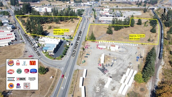
SECTION 12 TOWNSHIP 15 RANGE 3W QUARTER NW SW PLAT JACKSON FRUIT TRACT PTN LT 29 DOCUMENT 008/054 BEING THE E 2.79AC M/L. (OTHER PTN LT 29 IS 55702900000, IN 11-15-3W)
55702900000
THURSTON
Vacantlandnec
Washington
AC
29
B and X Area of moderate flood hazard, usually the area between the limits of the 100-year and 500-year floods.
4.46 AC
2024
Outlying Thurston County
2025
Olympia
012720
NEARBY LISTINGS FOR SALE OR LEASE
DEMOGRAPHICS near Unknown
1 mile
3 mile
5 mile
2025 Total Population
2,101
8,392
21,982
2030 Population
2,185
8,546
22,402
Pop Growth 2025-2030
+ 4.00%
+ 1.84%
+ 1.91%
Average Age
37
41
41
2025 Total Households
687
2,961
8,030
HH Growth 2025-2030
+ 3.78%
+ 1.79%
+ 1.92%
Median Household Inc
$86,119
$97,563
$83,882
Avg Household Size
2.90
2.80
2.60
2025 Avg HH Vehicles
3.00
3.00
2.00
Median Home Value
$342,142
$433,896
$426,859
Median Year Built
2001
1995
1992
Nearby Places
Map Layers
Map Styles
 Street
 Aerial
Layers
 Traffic
 Biking
Places
Listings with unknown addresses are not visible on the map
- Restaurants
- Banks
- Shops
- Fitness
- Groceries
PUBLIC TRANSPORTATION
COMMUTER RAIL
Centralia Amtrak Station (Amtrak Cascades - Amtrak, Coast Starlight - Amtrak)
Drive
Walk
Distance
Centralia Amtrak Station (Amtrak Cascades - Amtrak, Coast Starlight - Amtrak)
13 min
7.7 mi
Freight Ports
Port of Grays Harbor, WA
Drive
Walk
Distance
Port of Grays Harbor, WA
72 min
48.2 mi
SALE & LEASE HISTORY
LISTING DATE
SALE/LEASE

Nov 09, 2022
For Lease
Nearby Properties
Address
Land Use
TOTAL SIZE
Lot Size
Zoning
Address
Land Use
TOTAL SIZE
Lot Size
Zoning
441,608 SF
Address
Land Use
TOTAL SIZE
Lot Size
Zoning
155,458 SF
15.79 AC
PMP
Address
Land Use
TOTAL SIZE
Lot Size
Zoning
231,419 SF
209.52 AC
PID
Address
Land Use
TOTAL SIZE
Lot Size
Zoning
738,962 SF
16.50 AC
Address
Land Use
TOTAL SIZE
Lot Size
Zoning
297,970 SF
19.32 AC
PID
Address
Land Use
TOTAL SIZE
Lot Size
Zoning
158,948 SF
77.13 AC
RRR1/5
Address
Land Use
TOTAL SIZE
Lot Size
Zoning
196,060 SF
24.68 AC
PMP
Address
Land Use
TOTAL SIZE
Lot Size
Zoning
23,908 SF
3.74 AC
AC
Address
Land Use
TOTAL SIZE
Lot Size
Zoning
22.44 AC
PMP
Address
Land Use
TOTAL SIZE
Lot Size
Zoning
4,508 SF
15.84 AC
RDD5
Address
Land Use
TOTAL SIZE
Lot Size
Zoning
768 SF
34.16 AC
PID
Address
Land Use
TOTAL SIZE
Lot Size
Zoning
12,616 SF
7.56 AC
AC
Address
Land Use
TOTAL SIZE
Lot Size
Zoning
28,248 SF
4.92 AC
PID
Address
Land Use
TOTAL SIZE
Lot Size
Zoning
34,408 SF
7.21 AC
LI
Address
Land Use
TOTAL SIZE
Lot Size
Zoning
5.70 AC
AC
Address
Land Use
TOTAL SIZE
Lot Size
Zoning
36,440 SF
1.92 AC
AC
Address
Land Use
TOTAL SIZE
Lot Size
Zoning
10,672 SF
22.93 AC
RCC
Address
Land Use
TOTAL SIZE
Lot Size
Zoning
2,604 SF
6.85 AC
RRR1/5
Address
Land Use
TOTAL SIZE
Lot Size
Zoning
34,916 SF
62.68 AC
RRR1/5
Address
Land Use
TOTAL SIZE
Lot Size
Zoning
9.34 AC
PID
Address
Land Use
TOTAL SIZE
Lot Size
Zoning
4,997 SF
1.13 AC
AC
Address
Land Use
TOTAL SIZE
Lot Size
Zoning
4,320 SF
1.08 AC
AC
Address
Land Use
TOTAL SIZE
Lot Size
Zoning
8,423 SF
0.72 AC
AC
Address
Land Use
TOTAL SIZE
Lot Size
Zoning
115,874 SF
46.79 AC
RRR1/5
Address
Land Use
TOTAL SIZE
Lot Size
Zoning
9.86 AC
PID
Address
Land Use
TOTAL SIZE
Lot Size
Zoning
23,941 SF
4.37 AC
PID
Address
Land Use
TOTAL SIZE
Lot Size
Zoning
2,400 SF
9.51 AC
AC
Address
Land Use
TOTAL SIZE
Lot Size
Zoning
10.42 AC
PMP
Address
Land Use
TOTAL SIZE
Lot Size
Zoning
10,667 SF
0.97 AC
PID
Address
Land Use
TOTAL SIZE
Lot Size
Zoning
421.91 AC
PP
The World's #1 Commercial Real Estate Marketplace
Connect with us
© 2026 CoStar Group
The information above has been obtained from sources believed reliable. While we do not doubt its accuracy we have not verified it and make no guarantee, warranty or representation about it. It is your responsibility to independently confirm its accuracy and completeness. Any projections, opinions, assumptions, or estimates used are for example only and do not represent the current or future performance of the property. The value of this transaction to you depends on tax and other factors which should be evaluated by your tax, financial, and legal advisors. You and your advisors should conduct a careful, independent investigation of the property to determine to your satisfaction the suitability of the property for your needs.