Property Record
Unspecified, Reno, NV 89510
Property Detail
Unspecified
077-340-45
DLM 14 PARCEL 4-2-1-9
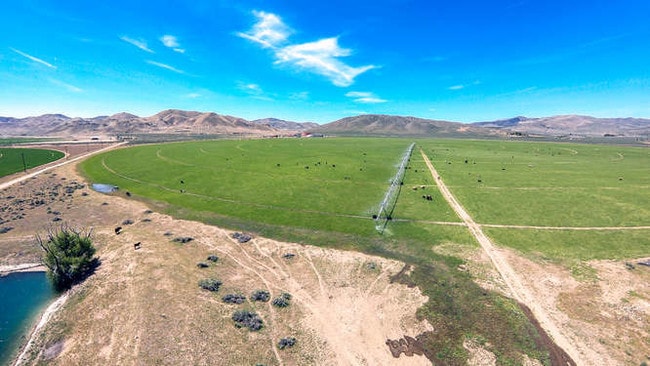
Agriculturalland
WASHOE
LDS 94% /
Nevada
A Areas with a 1% annual chance of flooding and a 26% chance of flooding over the life of a 30-year mortgage.
46.54 AC
0
N Outlying Washoe County
2026
Reno/Sparks
003501
Reno, NV
NEARBY LISTINGS FOR SALE OR LEASE
-
-
View all Reno listings for sale on LoopNet.com
DEMOGRAPHICS near Unspecified
1 mile
3 mile
5 mile
2024 Total Population
37
634
1,299
2029 Population
40
684
1,401
Pop Growth 2024-2029
+ 8.11%
+ 7.89%
+ 7.85%
Average Age
45
44
44
2024 Total Households
13
224
459
HH Growth 2024-2029
+ 7.69%
+ 8.04%
+ 8.06%
Median Household Inc
$71,249
$72,769
$72,369
Avg Household Size
2.50
2.60
2.60
2024 Avg HH Vehicles
3.00
3.00
3.00
Median Home Value
$714,285
$674,796
$674,603
Median Year Built
1998
1997
1996
Nearby Places
Map Layers
Map Styles
 Street
 Aerial
Transit
 Traffic
 Biking
Places
Listings with unknown addresses are not visible on the map
- Restaurants
- Banks
- Shops
- Fitness
- Groceries
PUBLIC TRANSPORTATION
AIRPORT
Reno/Tahoe International
Drive
Walk
Distance
Reno/Tahoe International
60 min
29.6 mi
Freight Ports
Port of Stockton
Drive
Walk
Distance
Port of Stockton
245 min
203.9 mi
SALE & LEASE HISTORY
LISTING DATE
SALE/LEASE

May 15, 2019
For Sale
Nearby Properties
Address
Land Use
TOTAL SIZE
Lot Size
Zoning
Address
Land Use
TOTAL SIZE
Lot Size
Zoning
75,629 SF
38.78 AC
NC 14% / M
Address
Land Use
TOTAL SIZE
Lot Size
Zoning
3,607 SF
5 AC
HDR
Address
Land Use
TOTAL SIZE
Lot Size
Zoning
1,440 SF
148.15 AC
PSP
Address
Land Use
TOTAL SIZE
Lot Size
Zoning
3,528 SF
2.14 AC
NC
Address
Land Use
TOTAL SIZE
Lot Size
Zoning
554.22 AC
PSP 2% /
Address
Land Use
TOTAL SIZE
Lot Size
Zoning
720 SF
40.44 AC
LDS 84% /
Address
Land Use
TOTAL SIZE
Lot Size
Zoning
42.53 AC
GR
Address
Land Use
TOTAL SIZE
Lot Size
Zoning
40.51 AC
GR
Address
Land Use
TOTAL SIZE
Lot Size
Zoning
67.92 AC
GRA
Address
Land Use
TOTAL SIZE
Lot Size
Zoning
40.01 AC
GR
Address
Land Use
TOTAL SIZE
Lot Size
Zoning
42.25 AC
GRA
Address
Land Use
TOTAL SIZE
Lot Size
Zoning
3,200 SF
40.62 AC
GR
Address
Land Use
TOTAL SIZE
Lot Size
Zoning
66.45 AC
GRA
Address
Land Use
TOTAL SIZE
Lot Size
Zoning
45.81 AC
GRA
Address
Land Use
TOTAL SIZE
Lot Size
Zoning
57.05 AC
GRA
Address
Land Use
TOTAL SIZE
Lot Size
Zoning
40 AC
MDR
Address
Land Use
TOTAL SIZE
Lot Size
Zoning
45.45 AC
NC 32% / M
Address
Land Use
TOTAL SIZE
Lot Size
Zoning
40.01 AC
MDR
Address
Land Use
TOTAL SIZE
Lot Size
Zoning
40.43 AC
MDR
Address
Land Use
TOTAL SIZE
Lot Size
Zoning
40.40 AC
MDR
Address
Land Use
TOTAL SIZE
Lot Size
Zoning
45.57 AC
NC 85% / G
Address
Land Use
TOTAL SIZE
Lot Size
Zoning
40.06 AC
MDR
Address
Land Use
TOTAL SIZE
Lot Size
Zoning
198.13 AC
GRA
Address
Land Use
TOTAL SIZE
Lot Size
Zoning
80.76 AC
GRA
Address
Land Use
TOTAL SIZE
Lot Size
Zoning
55.52 AC
GRA
Address
Land Use
TOTAL SIZE
Lot Size
Zoning
40 AC
GRA
Address
Land Use
TOTAL SIZE
Lot Size
Zoning
40.52 AC
HDR
Address
Land Use
TOTAL SIZE
Lot Size
Zoning
40 AC
GR
Address
Land Use
TOTAL SIZE
Lot Size
Zoning
47.44 AC
GR
Address
Land Use
TOTAL SIZE
Lot Size
Zoning
40.39 AC
GRA
The World's #1 Commercial Real Estate Marketplace
Connect with us
© 2026 CoStar Group
The information above has been obtained from sources believed reliable. While we do not doubt its accuracy we have not verified it and make no guarantee, warranty or representation about it. It is your responsibility to independently confirm its accuracy and completeness. Any projections, opinions, assumptions, or estimates used are for example only and do not represent the current or future performance of the property. The value of this transaction to you depends on tax and other factors which should be evaluated by your tax, financial, and legal advisors. You and your advisors should conduct a careful, independent investigation of the property to determine to your satisfaction the suitability of the property for your needs.