Property Record
Up-River Rd, Corpus Christi, TX 78410

Property Detail
Up-River Rd
Corpus Christi, TX
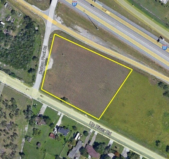
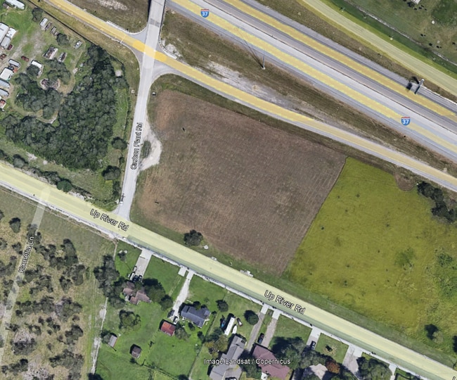
ASSESSORS MAP 138 3.1 ACS OUT OF TR 7 ABS 850 SUR 422 (FORMERLY 263-138-702)
185744
NUECES
Commercialacreage
Texas
R-1B
7
B and X Area of moderate flood hazard, usually the area between the limits of the 100-year and 500-year floods.
3.10 AC
0
Northwest
2025
Corpus Christi
003601
NEARBY LISTINGS FOR SALE OR LEASE
DEMOGRAPHICS near Up-River Rd
1 mile
3 mile
5 mile
2025 Total Population
6,350
21,455
27,612
2030 Population
6,332
21,291
27,451
Pop Growth 2025-2030
(0.28%)
(0.76%)
(0.58%)
Average Age
36
37
37
2025 Total Households
2,306
7,614
9,744
HH Growth 2025-2030
(0.56%)
(1.05%)
(0.87%)
Median Household Inc
$74,130
$70,832
$72,512
Avg Household Size
2.70
2.70
2.80
2025 Avg HH Vehicles
2.00
2.00
2.00
Median Home Value
$237,812
$208,804
$209,816
Median Year Built
1993
1986
1985
Nearby Places
Map Layers
Map Styles
 Street
 Aerial
Transit
 Traffic
 Biking
Places
Listings with unknown addresses are not visible on the map
- Restaurants
- Banks
- Shops
- Fitness
- Groceries
PUBLIC TRANSPORTATION
AIRPORT
Corpus Christi International
Drive
Walk
Distance
Corpus Christi International
17 min
10.9 mi
Freight Ports
Port of Corpus Christi
Drive
Walk
Distance
Port of Corpus Christi
14 min
11.5 mi
SALE & LEASE HISTORY
LISTING DATE
SALE/LEASE

Oct 14, 2016
For Sale
Nov 18, 2021
For Sale
Nearby Properties
Address
Land Use
TOTAL SIZE
Lot Size
Zoning
Address
Land Use
TOTAL SIZE
Lot Size
Zoning
243,200 SF
59.43 AC
R1B
Address
Land Use
TOTAL SIZE
Lot Size
Zoning
126,708 SF
18.17 AC
R1B
Address
Land Use
TOTAL SIZE
Lot Size
Zoning
191,500 SF
14.33 AC
R1B
Address
Land Use
TOTAL SIZE
Lot Size
Zoning
368.71 AC
OCL
Address
Land Use
TOTAL SIZE
Lot Size
Zoning
7,450 SF
132 AC
R1B
Address
Land Use
TOTAL SIZE
Lot Size
Zoning
115,182 SF
12.34 AC
R1B
Address
Land Use
TOTAL SIZE
Lot Size
Zoning
234.07 AC
OCL
Address
Land Use
TOTAL SIZE
Lot Size
Zoning
141,800 SF
6 AC
Address
Land Use
TOTAL SIZE
Lot Size
Zoning
276.16 AC
R1B
Address
Land Use
TOTAL SIZE
Lot Size
Zoning
151,918 SF
10 AC
I-3
Address
Land Use
TOTAL SIZE
Lot Size
Zoning
69,436 SF
10.82 AC
R1B
Address
Land Use
TOTAL SIZE
Lot Size
Zoning
56,345 SF
2.47 AC
Address
Land Use
TOTAL SIZE
Lot Size
Zoning
1,750 SF
4.67 AC
R-1B
Address
Land Use
TOTAL SIZE
Lot Size
Zoning
167.06 AC
Address
Land Use
TOTAL SIZE
Lot Size
Zoning
66,052 SF
23.95 AC
I2SP08
Address
Land Use
TOTAL SIZE
Lot Size
Zoning
36.26 AC
OCL
Address
Land Use
TOTAL SIZE
Lot Size
Zoning
333.74 AC
OCL
Address
Land Use
TOTAL SIZE
Lot Size
Zoning
81.50 AC
OCL
Address
Land Use
TOTAL SIZE
Lot Size
Zoning
14,765 SF
80 AC
R1B
Address
Land Use
TOTAL SIZE
Lot Size
Zoning
81,619 SF
9 AC
B4
Address
Land Use
TOTAL SIZE
Lot Size
Zoning
39,046 SF
4.24 AC
R1B
Address
Land Use
TOTAL SIZE
Lot Size
Zoning
36,288 SF
1.63 AC
B-4
Address
Land Use
TOTAL SIZE
Lot Size
Zoning
2,542 SF
4.38 AC
B-4
Address
Land Use
TOTAL SIZE
Lot Size
Zoning
38,274 SF
10.63 AC
FR
Address
Land Use
TOTAL SIZE
Lot Size
Zoning
57,426 SF
6.88 AC
B-4
Address
Land Use
TOTAL SIZE
Lot Size
Zoning
17,906 SF
10.36 AC
B-4
Address
Land Use
TOTAL SIZE
Lot Size
Zoning
33,746 SF
0.53 AC
B-4
Address
Land Use
TOTAL SIZE
Lot Size
Zoning
49,884 SF
10.09 AC
FR
Address
Land Use
TOTAL SIZE
Lot Size
Zoning
26,680 SF
1.84 AC
B-4
Address
Land Use
TOTAL SIZE
Lot Size
Zoning
7,454 SF
54.84 AC
FR
The World's #1 Commercial Real Estate Marketplace
Connect with us
© 2026 CoStar Group
The information above has been obtained from sources believed reliable. While we do not doubt its accuracy we have not verified it and make no guarantee, warranty or representation about it. It is your responsibility to independently confirm its accuracy and completeness. Any projections, opinions, assumptions, or estimates used are for example only and do not represent the current or future performance of the property. The value of this transaction to you depends on tax and other factors which should be evaluated by your tax, financial, and legal advisors. You and your advisors should conduct a careful, independent investigation of the property to determine to your satisfaction the suitability of the property for your needs.