Property Record
2321 Upper Bottom Rd, Saint Charles, MO 63303

This Property Is For Sale
NEARBY LISTINGS FOR SALE OR LEASE
Property Detail
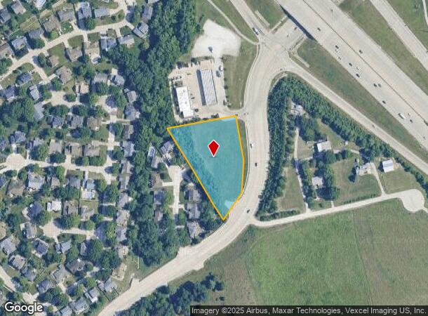
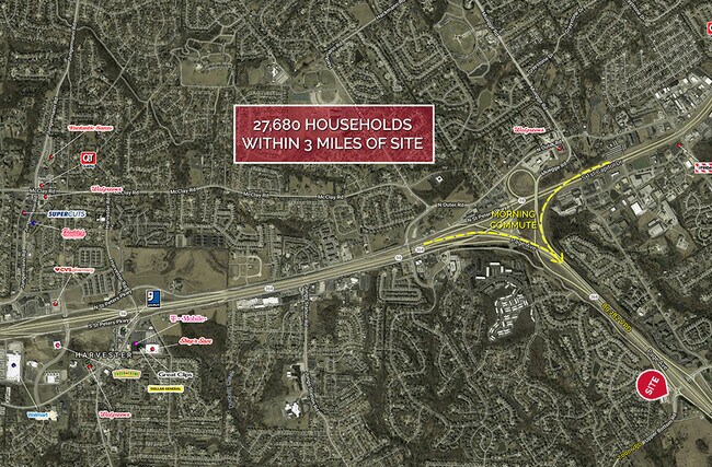
2321 Upper Bottom Rd
St. Louis, MO-IL
Centre At Page Crossing Final Plat
3-0117-A565-00-0001.0000000
CENTRE AT PAGE CROSSING FINAL PLAT LOT 1
Commercialnec
St. Charles
X
Missouri
29183C0457G
1
2024
1.93 AC
2025
St Charles County
311145
St. Louis
3,729 SF
DEMOGRAPHICS near 2321 Upper Bottom Rd
1 Mile
3 Mile
5 Mile
2024 Total Population
6,228
56,648
172,809
2029 Population
6,574
59,788
180,135
Pop Growth 2024-2029
+ 5.56%
+ 5.54%
+ 4.24%
Average Age
43
42
42
2024 Total Households
2,561
24,257
72,042
HH Growth 2024-2029
+ 5.66%
+ 5.65%
+ 4.27%
Median Household Inc
$103,950
$84,344
$84,764
Avg Household Size
2.40
2.30
2.30
2024 Avg HH Vehicles
2.00
2.00
2.00
Median Home Value
$328,929
$270,220
$253,764
Median Year Built
1991
1986
1981
Nearby Places
Map Layers
Map Styles
 Street
 Aerial
- Restaurants
- Banks
- Shops
- Fitness
- Groceries
PUBLIC TRANSPORTATION
AIRPORT
St Louis Lambert International
DRIVE
WALK
Distance
St Louis Lambert International
21 min
13.4 mi
Freight Ports
Port Milwaukee
DRIVE
WALK
Distance
Port Milwaukee
441 min
386.6 mi
Nearby Properties
Address
Land Use
TOTAL SIZE
Lot Size
Zoning
Address
Land Use
TOTAL SIZE
Lot Size
Zoning
553,382 SF
109.67 AC
FPNU
Address
Land Use
TOTAL SIZE
Lot Size
Zoning
440,000 SF
2.11 AC
Address
Land Use
TOTAL SIZE
Lot Size
Zoning
256,719 SF
27 AC
104PDM
Address
Land Use
TOTAL SIZE
Lot Size
Zoning
52,664 SF
13.59 AC
Address
Land Use
TOTAL SIZE
Lot Size
Zoning
13.45 AC
PD-M
Address
Land Use
TOTAL SIZE
Lot Size
Zoning
488,536 SF
23.53 AC
AF0
Address
Land Use
TOTAL SIZE
Lot Size
Zoning
281,074 SF
8.79 AC
Address
Land Use
TOTAL SIZE
Lot Size
Zoning
312,516 SF
2.18 AC
Address
Land Use
TOTAL SIZE
Lot Size
Zoning
120,050 SF
1.51 AC
Address
Land Use
TOTAL SIZE
Lot Size
Zoning
87,027 SF
16.04 AC
AC4
Address
Land Use
TOTAL SIZE
Lot Size
Zoning
273,184 SF
20.05 AC
Address
Land Use
TOTAL SIZE
Lot Size
Zoning
273,398 SF
20.08 AC
AB2
Address
Land Use
TOTAL SIZE
Lot Size
Zoning
316,064 SF
1.84 AC
Address
Land Use
TOTAL SIZE
Lot Size
Zoning
55.46 AC
AF0
Address
Land Use
TOTAL SIZE
Lot Size
Zoning
220,089 SF
25.47 AC
AA7
Address
Land Use
TOTAL SIZE
Lot Size
Zoning
219,966 SF
9.09 AC
Address
Land Use
TOTAL SIZE
Lot Size
Zoning
100,633 SF
1.02 AC
Address
Land Use
TOTAL SIZE
Lot Size
Zoning
263,495 SF
20.10 AC
Address
Land Use
TOTAL SIZE
Lot Size
Zoning
19,493 SF
3.01 AC
Address
Land Use
TOTAL SIZE
Lot Size
Zoning
32,108 SF
0.90 AC
AF0
Address
Land Use
TOTAL SIZE
Lot Size
Zoning
260,584 SF
16.29 AC
Address
Land Use
TOTAL SIZE
Lot Size
Zoning
45,308 SF
11.54 AC
AC4
Address
Land Use
TOTAL SIZE
Lot Size
Zoning
116,031 SF
0.63 AC
Address
Land Use
TOTAL SIZE
Lot Size
Zoning
8.90 AC
Address
Land Use
TOTAL SIZE
Lot Size
Zoning
204,674 SF
8.80 AC
AF0
Address
Land Use
TOTAL SIZE
Lot Size
Zoning
190,728 SF
8.04 AC
Address
Land Use
TOTAL SIZE
Lot Size
Zoning
33,589 SF
194.38 AC
104NU
Address
Land Use
TOTAL SIZE
Lot Size
Zoning
63,954 SF
0.56 AC
Address
Land Use
TOTAL SIZE
Lot Size
Zoning
75,933 SF
1.84 AC
Address
Land Use
TOTAL SIZE
Lot Size
Zoning
10.75 AC
The World's #1 Commercial Real Estate Marketplace
Connect with us
© 2025 CoStar Group
The information above has been obtained from sources believed reliable. While we do not doubt its accuracy we have not verified it and make no guarantee, warranty or representation about it. It is your responsibility to independently confirm its accuracy and completeness. Any projections, opinions, assumptions, or estimates used are for example only and do not represent the current or future performance of the property. The value of this transaction to you depends on tax and other factors which should be evaluated by your tax, financial, and legal advisors. You and your advisors should conduct a careful, independent investigation of the property to determine to your satisfaction the suitability of the property for your needs.