Property Record
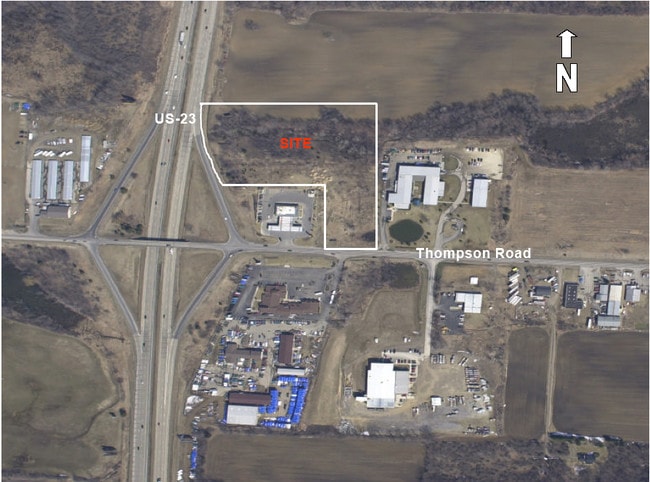
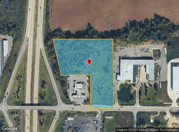
Thompson Rd, Fenton, MI 48430


NEARBY LISTINGS FOR SALE OR LEASE
Property Detail
Thompson Rd
06-03-200-029
A PARCEL OF LAND BEG N 89 DEG 34 MIN 47 SEC W 2032.03 FT FROM E 1/4 COR OF SEC TH N 0 DEG 20 MIN 15 SEC E 679 FT TH N 89 DEG
Commercialacreage
Genesee
X
Michigan
26049C0426D
6.13 AC
2024
Flint
2025
Detroit
013206
Flint, MI
DEMOGRAPHICS near Thompson Rd
1 mile
3 mile
5 mile
2024 Total Population
885
10,818
38,142
2029 Population
853
10,565
37,234
Pop Growth 2024-2029
(3.62%)
(2.34%)
(2.38%)
Average Age
43
43
42
2024 Total Households
354
4,310
16,055
HH Growth 2024-2029
(3.67%)
(2.34%)
(2.42%)
Median Household Inc
$110,032
$106,437
$80,941
Avg Household Size
2.50
2.50
2.30
2024 Avg HH Vehicles
2.00
2.00
2.00
Median Home Value
$280,356
$293,569
$250,909
Median Year Built
1979
1990
1988
Nearby Places
Map Layers
Map Styles
 Street
 Aerial
Transit
 Traffic
 Biking
Places
Listings with unknown addresses are not visible on the map
- Restaurants
- Banks
- Shops
- Fitness
- Groceries
PUBLIC TRANSPORTATION
AIRPORT
Bishop International
Drive
Walk
Distance
Bishop International
20 min
9.3 mi
Freight Ports
Port of Toledo
Drive
Walk
Distance
Port of Toledo
121 min
102.0 mi
SALE & LEASE HISTORY
LISTING DATE
SALE/LEASE

Sep 24, 2016
For Sale
Nearby Properties
Address
Land Use
TOTAL SIZE
Lot Size
Zoning
Address
Land Use
TOTAL SIZE
Lot Size
Zoning
135,840 SF
PUD
Address
Land Use
TOTAL SIZE
Lot Size
Zoning
752,146 SF
100 AC
RA
Address
Land Use
TOTAL SIZE
Lot Size
Zoning
104,867 SF
PERSONA
Address
Land Use
TOTAL SIZE
Lot Size
Zoning
10,479 SF
1.19 AC
R-3
Address
Land Use
TOTAL SIZE
Lot Size
Zoning
9,399 SF
0.57 AC
R-3
Address
Land Use
TOTAL SIZE
Lot Size
Zoning
754 SF
15.74 AC
PUD
Address
Land Use
TOTAL SIZE
Lot Size
Zoning
5,933 SF
0.96 AC
R-3
Address
Land Use
TOTAL SIZE
Lot Size
Zoning
6,525 SF
0.70 AC
R-3
Address
Land Use
TOTAL SIZE
Lot Size
Zoning
6,088 SF
0.89 AC
R-3
Address
Land Use
TOTAL SIZE
Lot Size
Zoning
53,951 SF
8.08 AC
M-1
Address
Land Use
TOTAL SIZE
Lot Size
Zoning
6,342 SF
0.99 AC
R-4
Address
Land Use
TOTAL SIZE
Lot Size
Zoning
4,778 SF
0.45 AC
R-3
Address
Land Use
TOTAL SIZE
Lot Size
Zoning
3,391 SF
1.25 AC
R-5
Address
Land Use
TOTAL SIZE
Lot Size
Zoning
5,991 SF
1.73 AC
R-3
Address
Land Use
TOTAL SIZE
Lot Size
Zoning
3,954 SF
0.89 AC
R-3
Address
Land Use
TOTAL SIZE
Lot Size
Zoning
6,990 SF
0.79 AC
R-3
Address
Land Use
TOTAL SIZE
Lot Size
Zoning
7,664 SF
0.32 AC
PUD
Address
Land Use
TOTAL SIZE
Lot Size
Zoning
6,826 SF
0.34 AC
R-3
Address
Land Use
TOTAL SIZE
Lot Size
Zoning
5,299 SF
0.52 AC
R-3
Address
Land Use
TOTAL SIZE
Lot Size
Zoning
2,912 SF
0.50 AC
R-3
Address
Land Use
TOTAL SIZE
Lot Size
Zoning
4,870 SF
0.30 AC
R-3
Address
Land Use
TOTAL SIZE
Lot Size
Zoning
4,491 SF
0.78 AC
R-3
Address
Land Use
TOTAL SIZE
Lot Size
Zoning
17.96 AC
PUD
Address
Land Use
TOTAL SIZE
Lot Size
Zoning
3,367 SF
0.38 AC
R-3
Address
Land Use
TOTAL SIZE
Lot Size
Zoning
6,702 SF
0.66 AC
R-5
Address
Land Use
TOTAL SIZE
Lot Size
Zoning
4,127 SF
4.81 AC
R-3
Address
Land Use
TOTAL SIZE
Lot Size
Zoning
4,159 SF
0.39 AC
R-3
Address
Land Use
TOTAL SIZE
Lot Size
Zoning
3.64 AC
R-3
Address
Land Use
TOTAL SIZE
Lot Size
Zoning
8,278 SF
0.11 AC
R-5
Address
Land Use
TOTAL SIZE
Lot Size
Zoning
0.22 AC
R-3
The World's #1 Commercial Real Estate Marketplace
Connect with us
© 2026 CoStar Group
The information above has been obtained from sources believed reliable. While we do not doubt its accuracy we have not verified it and make no guarantee, warranty or representation about it. It is your responsibility to independently confirm its accuracy and completeness. Any projections, opinions, assumptions, or estimates used are for example only and do not represent the current or future performance of the property. The value of this transaction to you depends on tax and other factors which should be evaluated by your tax, financial, and legal advisors. You and your advisors should conduct a careful, independent investigation of the property to determine to your satisfaction the suitability of the property for your needs.