Property Record
1585 N Highway 395 S, Gardnerville, NV 89410
NEARBY LISTINGS FOR SALE OR LEASE
Property Detail
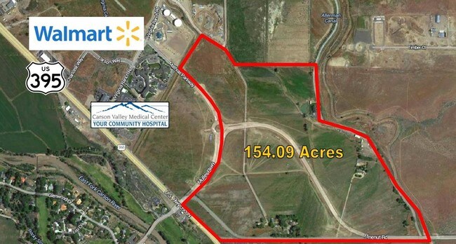
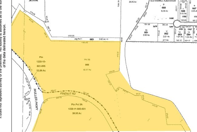
1585 N Highway 395 S
Gardnerville Ranchos, NV
LOT B
1220-10-601-005
Douglas
Residentialacreage
Nevada
A
b
32005C0262H
33.58 AC
2024
Douglas County
2025
Reno/Sparks
002300
DEMOGRAPHICS near 1585 N Highway 395 S
1 Mile
3 Mile
5 Mile
2024 Total Population
936
19,670
25,501
2029 Population
942
19,917
25,916
Pop Growth 2024-2029
+ 0.64%
+ 1.26%
+ 1.63%
Average Age
46
46
47
2024 Total Households
376
8,320
10,928
HH Growth 2024-2029
+ 0.80%
+ 1.32%
+ 1.67%
Median Household Inc
$82,197
$75,454
$78,349
Avg Household Size
2.50
2.30
2.30
2024 Avg HH Vehicles
2.00
2.00
2.00
Median Home Value
$459,183
$428,151
$451,580
Median Year Built
1984
1993
1993
Nearby Places
Map Layers
Map Styles
 Street
 Aerial
- Restaurants
- Banks
- Shops
- Fitness
- Groceries
SALE & LEASE HISTORY
LISTING DATE
SALE/LEASE

Sep 24, 2016
For Sale
Nearby Properties
Address
Land Use
TOTAL SIZE
Lot Size
Zoning
Address
Land Use
TOTAL SIZE
Lot Size
Zoning
266,955 SF
26.62 AC
Address
Land Use
TOTAL SIZE
Lot Size
Zoning
128,688 SF
10 AC
Address
Land Use
TOTAL SIZE
Lot Size
Zoning
161,867 SF
30.13 AC
Address
Land Use
TOTAL SIZE
Lot Size
Zoning
67,309 SF
21.20 AC
Address
Land Use
TOTAL SIZE
Lot Size
Zoning
153,623 SF
17.65 AC
Address
Land Use
TOTAL SIZE
Lot Size
Zoning
119,616 SF
8.70 AC
Address
Land Use
TOTAL SIZE
Lot Size
Zoning
83,040 SF
6.51 AC
Address
Land Use
TOTAL SIZE
Lot Size
Zoning
108,444 SF
25.72 AC
Address
Land Use
TOTAL SIZE
Lot Size
Zoning
153,210 SF
13.21 AC
Address
Land Use
TOTAL SIZE
Lot Size
Zoning
68,860 SF
12 AC
Address
Land Use
TOTAL SIZE
Lot Size
Zoning
49,737 SF
5.91 AC
Address
Land Use
TOTAL SIZE
Lot Size
Zoning
54,000 SF
5.35 AC
Address
Land Use
TOTAL SIZE
Lot Size
Zoning
64,813 SF
9.37 AC
Address
Land Use
TOTAL SIZE
Lot Size
Zoning
5,194 SF
36.84 AC
Address
Land Use
TOTAL SIZE
Lot Size
Zoning
31,543 SF
6.20 AC
Address
Land Use
TOTAL SIZE
Lot Size
Zoning
35,365 SF
5.08 AC
Address
Land Use
TOTAL SIZE
Lot Size
Zoning
60,424 SF
8.08 AC
Address
Land Use
TOTAL SIZE
Lot Size
Zoning
52,392 SF
3.10 AC
Address
Land Use
TOTAL SIZE
Lot Size
Zoning
20,587 SF
5.08 AC
Address
Land Use
TOTAL SIZE
Lot Size
Zoning
Address
Land Use
TOTAL SIZE
Lot Size
Zoning
42,150 SF
4.28 AC
Address
Land Use
TOTAL SIZE
Lot Size
Zoning
6,533 SF
22.29 AC
Address
Land Use
TOTAL SIZE
Lot Size
Zoning
15,018 SF
4.35 AC
Address
Land Use
TOTAL SIZE
Lot Size
Zoning
51.31 AC
Address
Land Use
TOTAL SIZE
Lot Size
Zoning
2,359 SF
29 AC
Address
Land Use
TOTAL SIZE
Lot Size
Zoning
26,745 SF
2.90 AC
Address
Land Use
TOTAL SIZE
Lot Size
Zoning
43,829 SF
5.39 AC
Address
Land Use
TOTAL SIZE
Lot Size
Zoning
1,632 SF
7.11 AC
Address
Land Use
TOTAL SIZE
Lot Size
Zoning
15,065 SF
10.79 AC
Address
Land Use
TOTAL SIZE
Lot Size
Zoning
160.37 AC
The World's #1 Commercial Real Estate Marketplace
Connect with us
© 2025 CoStar Group
The information above has been obtained from sources believed reliable. While we do not doubt its accuracy we have not verified it and make no guarantee, warranty or representation about it. It is your responsibility to independently confirm its accuracy and completeness. Any projections, opinions, assumptions, or estimates used are for example only and do not represent the current or future performance of the property. The value of this transaction to you depends on tax and other factors which should be evaluated by your tax, financial, and legal advisors. You and your advisors should conduct a careful, independent investigation of the property to determine to your satisfaction the suitability of the property for your needs.