Property Record
Se Us Highway 431 At Us Highway 78 E, Anniston, AL 36207
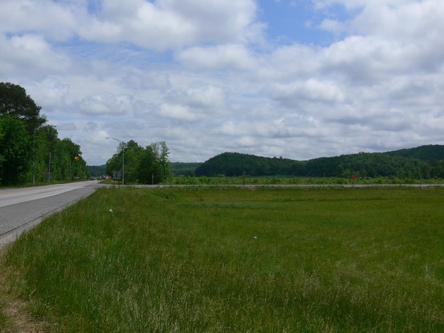
This Property Is For Sale
NEARBY LISTINGS FOR SALE OR LEASE
-
-
View all Anniston listings for sale on LoopNet.com
Property Detail
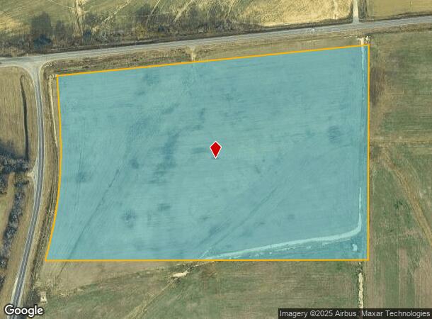
Se Us Highway 431 At Us Highway 78 E
20-04-20-0-000-010.000
SEC 20 TSP 16S RNG 09E BEG SE INT US HWY 78 E & US HWY 431 TH E 1435.2 S 1007 W 1484.64 N 871.1 TO POB OXFORD AL
Timberlandforesttreesagricultural
Calhoun
AE
Alabama
01015C0426E
31 AC
2025
Gadsden/Anniston Area
2025
Other Market Areas
000900
Anniston-Oxford, AL
DEMOGRAPHICS near Se Us Highway 431 At Us Highway 78 E
1 Mile
3 Mile
5 Mile
2024 Total Population
520
4,940
12,995
2029 Population
515
4,828
12,724
Pop Growth 2024-2029
(0.96%)
(2.27%)
(2.09%)
Average Age
40
42
43
2024 Total Households
198
1,996
5,379
HH Growth 2024-2029
(1.01%)
(2.45%)
(2.25%)
Median Household Inc
$47,083
$66,484
$70,409
Avg Household Size
2.50
2.40
2.40
2024 Avg HH Vehicles
2.00
2.00
2.00
Median Home Value
$181,999
$208,416
$199,499
Median Year Built
1982
1985
1984
Nearby Places
Map Layers
Map Styles
 Street
 Aerial
- Restaurants
- Banks
- Shops
- Fitness
- Groceries
PUBLIC TRANSPORTATION
COMMUTER RAIL
Anniston Amtrak Station (Crescent - Amtrak)
DRIVE
WALK
Distance
Anniston Amtrak Station (Crescent - Amtrak)
14 min
9.1 mi
Freight Ports
Port of Panama City
DRIVE
WALK
Distance
Port of Panama City
364 min
295.8 mi
Nearby Properties
Address
Land Use
TOTAL SIZE
Lot Size
Zoning
Address
Land Use
TOTAL SIZE
Lot Size
Zoning
160,000 SF
21 AC
Address
Land Use
TOTAL SIZE
Lot Size
Zoning
76,250 SF
14.60 AC
Address
Land Use
TOTAL SIZE
Lot Size
Zoning
4,030 SF
11.20 AC
Address
Land Use
TOTAL SIZE
Lot Size
Zoning
3 SF
38.22 AC
Address
Land Use
TOTAL SIZE
Lot Size
Zoning
36,997 SF
7.60 AC
Address
Land Use
TOTAL SIZE
Lot Size
Zoning
23,554 SF
5.50 AC
Address
Land Use
TOTAL SIZE
Lot Size
Zoning
8,594 SF
9.89 AC
Address
Land Use
TOTAL SIZE
Lot Size
Zoning
3,440 SF
1 AC
Address
Land Use
TOTAL SIZE
Lot Size
Zoning
9.90 AC
Address
Land Use
TOTAL SIZE
Lot Size
Zoning
16,102 SF
0.75 AC
Address
Land Use
TOTAL SIZE
Lot Size
Zoning
3,696 SF
4 AC
Address
Land Use
TOTAL SIZE
Lot Size
Zoning
8,400 SF
2.96 AC
Address
Land Use
TOTAL SIZE
Lot Size
Zoning
7,104 SF
2.30 AC
Address
Land Use
TOTAL SIZE
Lot Size
Zoning
1,920 SF
2.60 AC
Address
Land Use
TOTAL SIZE
Lot Size
Zoning
2,274 SF
33 AC
Address
Land Use
TOTAL SIZE
Lot Size
Zoning
7,796 SF
2.10 AC
Address
Land Use
TOTAL SIZE
Lot Size
Zoning
20,400 SF
26 AC
Address
Land Use
TOTAL SIZE
Lot Size
Zoning
9,651 SF
14 AC
Address
Land Use
TOTAL SIZE
Lot Size
Zoning
2,100 SF
2 AC
Address
Land Use
TOTAL SIZE
Lot Size
Zoning
11,900 SF
1.10 AC
Address
Land Use
TOTAL SIZE
Lot Size
Zoning
6,000 SF
1 AC
Address
Land Use
TOTAL SIZE
Lot Size
Zoning
7,918 SF
8.60 AC
Address
Land Use
TOTAL SIZE
Lot Size
Zoning
9,012 SF
1.20 AC
Address
Land Use
TOTAL SIZE
Lot Size
Zoning
1,606 SF
242 AC
Address
Land Use
TOTAL SIZE
Lot Size
Zoning
3,600 SF
6.40 AC
Address
Land Use
TOTAL SIZE
Lot Size
Zoning
3,741 SF
3 AC
Address
Land Use
TOTAL SIZE
Lot Size
Zoning
9,900 SF
5.10 AC
Address
Land Use
TOTAL SIZE
Lot Size
Zoning
7.70 AC
Address
Land Use
TOTAL SIZE
Lot Size
Zoning
7,600 SF
4.60 AC
Address
Land Use
TOTAL SIZE
Lot Size
Zoning
57.24 AC
The World's #1 Commercial Real Estate Marketplace
Connect with us
© 2026 CoStar Group
The information above has been obtained from sources believed reliable. While we do not doubt its accuracy we have not verified it and make no guarantee, warranty or representation about it. It is your responsibility to independently confirm its accuracy and completeness. Any projections, opinions, assumptions, or estimates used are for example only and do not represent the current or future performance of the property. The value of this transaction to you depends on tax and other factors which should be evaluated by your tax, financial, and legal advisors. You and your advisors should conduct a careful, independent investigation of the property to determine to your satisfaction the suitability of the property for your needs.