Property Record
Us 50, Aurora, IN 47001
Save to a Folder
{{folder.Name}}
{{folder.ListingIds.length}} Properties
{{folder.ListingIds.length}} Property
Create a New Folder
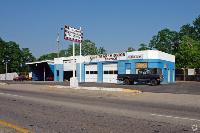
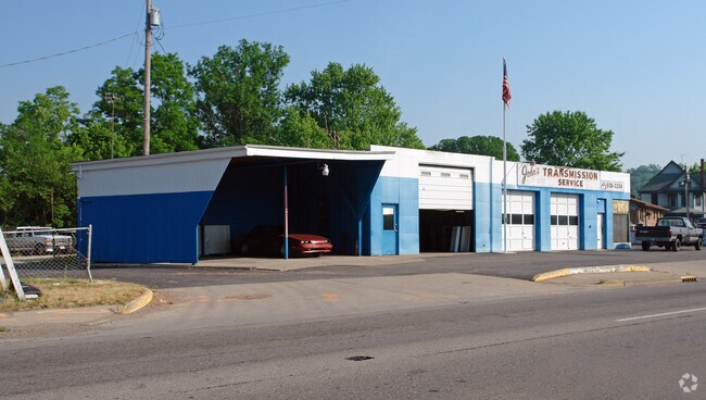
Property Detail
Us 50
Cincinnati, OH-KY-IN
07-548 PT 30 29-5-1 .69A ALSO CONTAINS: 15-07-29-403-069.000-003
15-07-32-102-002.000-003
DEARBORN
Autorepair
Indiana
AE The base floodplain where base flood elevations are provided. AE Zones are now used on new format FIRMs instead of A1-A30 Zones.
0.80 AC
2025
Dearborn County
2025
Cincinnati/Dayton
080500
NEARBY LISTINGS FOR SALE OR LEASE
DEMOGRAPHICS near Us 50
1 mile
3 mile
5 mile
2025 Total Population
2,639
7,144
19,594
2030 Population
2,709
7,313
19,980
Pop Growth 2025-2030
+ 2.65%
+ 2.37%
+ 1.97%
Average Age
40
41
41
2025 Total Households
1,080
2,893
7,901
HH Growth 2025-2030
+ 2.69%
+ 2.42%
+ 2.04%
Median Household Inc
$48,728
$59,801
$68,040
Avg Household Size
2.40
2.40
2.40
2025 Avg HH Vehicles
2.00
2.00
2.00
Median Home Value
$163,846
$192,301
$202,481
Median Year Built
1948
1961
1970
Nearby Places
Map Layers
Map Styles
 Street
 Aerial
Layers
 Traffic
 Biking
Places
Listings with unknown addresses are not visible on the map
- Restaurants
- Banks
- Shops
- Fitness
- Groceries
PUBLIC TRANSPORTATION
AIRPORT
Cincinnati/Northern Kentucky International
Drive
Walk
Distance
Cincinnati/Northern Kentucky International
41 min
22.6 mi
Freight Ports
Port of Toledo
Drive
Walk
Distance
Port of Toledo
267 min
224.7 mi
SALE & LEASE HISTORY
LISTING DATE
SALE/LEASE

Aug 04, 2022
For Sale
Nearby Properties
Address
Land Use
TOTAL SIZE
Lot Size
Zoning
Address
Land Use
TOTAL SIZE
Lot Size
Zoning
205,455 SF
20.32 AC
Address
Land Use
TOTAL SIZE
Lot Size
Zoning
12,000 SF
61.29 AC
Address
Land Use
TOTAL SIZE
Lot Size
Zoning
7,180 SF
16 AC
Address
Land Use
TOTAL SIZE
Lot Size
Zoning
111,861 SF
11.72 AC
Address
Land Use
TOTAL SIZE
Lot Size
Zoning
68,146 SF
7.06 AC
Address
Land Use
TOTAL SIZE
Lot Size
Zoning
1,392 SF
78 AC
Address
Land Use
TOTAL SIZE
Lot Size
Zoning
94,974 SF
8.06 AC
Address
Land Use
TOTAL SIZE
Lot Size
Zoning
2,853 SF
9 AC
Address
Land Use
TOTAL SIZE
Lot Size
Zoning
26,500 SF
14.36 AC
Address
Land Use
TOTAL SIZE
Lot Size
Zoning
242.80 AC
Address
Land Use
TOTAL SIZE
Lot Size
Zoning
24,496 SF
4.50 AC
Address
Land Use
TOTAL SIZE
Lot Size
Zoning
13,136 SF
2.42 AC
Address
Land Use
TOTAL SIZE
Lot Size
Zoning
22,368 SF
5.40 AC
Address
Land Use
TOTAL SIZE
Lot Size
Zoning
5,600 SF
132.85 AC
Address
Land Use
TOTAL SIZE
Lot Size
Zoning
119.30 AC
Address
Land Use
TOTAL SIZE
Lot Size
Zoning
24,209 SF
2.05 AC
Address
Land Use
TOTAL SIZE
Lot Size
Zoning
50,816 SF
4.68 AC
Address
Land Use
TOTAL SIZE
Lot Size
Zoning
1,200 SF
126.74 AC
Address
Land Use
TOTAL SIZE
Lot Size
Zoning
2,976 SF
100.32 AC
Address
Land Use
TOTAL SIZE
Lot Size
Zoning
15,212 SF
3.07 AC
Address
Land Use
TOTAL SIZE
Lot Size
Zoning
3,200 SF
12.46 AC
Address
Land Use
TOTAL SIZE
Lot Size
Zoning
4,393 SF
1.74 AC
Address
Land Use
TOTAL SIZE
Lot Size
Zoning
1,696 SF
132.80 AC
Address
Land Use
TOTAL SIZE
Lot Size
Zoning
1,288 SF
131.28 AC
Address
Land Use
TOTAL SIZE
Lot Size
Zoning
2,504 SF
177.96 AC
Address
Land Use
TOTAL SIZE
Lot Size
Zoning
4,875 SF
1.36 AC
Address
Land Use
TOTAL SIZE
Lot Size
Zoning
15,000 SF
5.75 AC
Address
Land Use
TOTAL SIZE
Lot Size
Zoning
Address
Land Use
TOTAL SIZE
Lot Size
Zoning
10,125 SF
1.41 AC
Address
Land Use
TOTAL SIZE
Lot Size
Zoning
26,000 SF
4.46 AC
The World's #1 Commercial Real Estate Marketplace
Connect with us
© 2026 CoStar Group
The information above has been obtained from sources believed reliable. While we do not doubt its accuracy we have not verified it and make no guarantee, warranty or representation about it. It is your responsibility to independently confirm its accuracy and completeness. Any projections, opinions, assumptions, or estimates used are for example only and do not represent the current or future performance of the property. The value of this transaction to you depends on tax and other factors which should be evaluated by your tax, financial, and legal advisors. You and your advisors should conduct a careful, independent investigation of the property to determine to your satisfaction the suitability of the property for your needs.