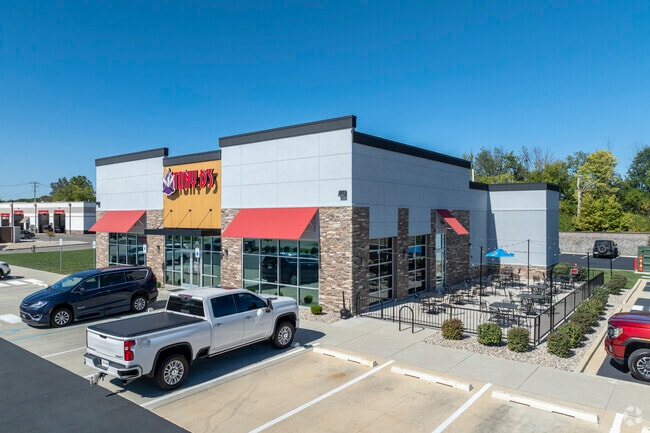
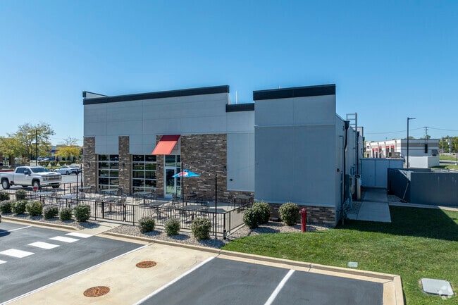
Property Record
5918 W Dragon Dr, New Palestine, IN 46163
Current Lease Availabilities
NEARBY LISTINGS FOR SALE OR LEASE
Property Detail
5918 W Dragon Dr
30-10-30-201-022.003-013
NEW PALESTINE COMMERCIAL CENTER L4 (CONTAINING 1.699AC) INCLUDES .330 AC OUT OF SEC 19
Restaurantbuilding
Hancock
A
Indiana
18145C0010C
1.70 AC
2024
Hancock County
2024
Indianapolis
410802
Indianapolis-Carmel-Anderson, IN
4,688 SF
DEMOGRAPHICS near 5918 W Dragon Dr
1 Mile
3 Mile
5 Mile
2024 Total Population
2,868
12,755
38,187
2029 Population
3,136
14,002
40,170
Pop Growth 2024-2029
+ 9.34%
+ 9.78%
+ 5.19%
Average Age
43
42
40
2024 Total Households
1,060
4,744
14,134
HH Growth 2024-2029
+ 9.72%
+ 10.22%
+ 5.61%
Median Household Inc
$105,655
$98,049
$94,389
Avg Household Size
2.70
2.60
2.70
2024 Avg HH Vehicles
3.00
3.00
2.00
Median Home Value
$272,124
$265,945
$248,535
Median Year Built
1990
1991
1991
Nearby Places
Map Layers
Map Styles
 Street
 Aerial
- Restaurants
- Banks
- Shops
- Fitness
- Groceries
PUBLIC TRANSPORTATION
AIRPORT
Indianapolis International
DRIVE
WALK
Distance
Indianapolis International
45 min
25.5 mi
Nearby Properties
Address
Land Use
TOTAL SIZE
Lot Size
Zoning
Address
Land Use
TOTAL SIZE
Lot Size
Zoning
107,950 SF
10.93 AC
Address
Land Use
TOTAL SIZE
Lot Size
Zoning
48,838 SF
15.09 AC
Address
Land Use
TOTAL SIZE
Lot Size
Zoning
12,786 SF
24.78 AC
ZO01
Address
Land Use
TOTAL SIZE
Lot Size
Zoning
16,282 SF
10.23 AC
Address
Land Use
TOTAL SIZE
Lot Size
Zoning
53,658 SF
12.24 AC
Address
Land Use
TOTAL SIZE
Lot Size
Zoning
21,778 SF
3.17 AC
Address
Land Use
TOTAL SIZE
Lot Size
Zoning
53,337 SF
10 AC
Address
Land Use
TOTAL SIZE
Lot Size
Zoning
3,168 SF
2.56 AC
Address
Land Use
TOTAL SIZE
Lot Size
Zoning
5,805 SF
2.54 AC
Address
Land Use
TOTAL SIZE
Lot Size
Zoning
3,806 SF
4.96 AC
Address
Land Use
TOTAL SIZE
Lot Size
Zoning
10,454 SF
8.69 AC
Address
Land Use
TOTAL SIZE
Lot Size
Zoning
9,900 SF
3.86 AC
Address
Land Use
TOTAL SIZE
Lot Size
Zoning
21,737 SF
6 AC
Address
Land Use
TOTAL SIZE
Lot Size
Zoning
4,956 SF
1.52 AC
Address
Land Use
TOTAL SIZE
Lot Size
Zoning
5,120 SF
2.79 AC
Address
Land Use
TOTAL SIZE
Lot Size
Zoning
13,000 SF
1.17 AC
Address
Land Use
TOTAL SIZE
Lot Size
Zoning
10,941 SF
1.24 AC
Address
Land Use
TOTAL SIZE
Lot Size
Zoning
9,065 SF
1.59 AC
Address
Land Use
TOTAL SIZE
Lot Size
Zoning
Address
Land Use
TOTAL SIZE
Lot Size
Zoning
4,200 SF
5 AC
Address
Land Use
TOTAL SIZE
Lot Size
Zoning
7,200 SF
6.62 AC
Address
Land Use
TOTAL SIZE
Lot Size
Zoning
6,264 SF
161.88 AC
Address
Land Use
TOTAL SIZE
Lot Size
Zoning
6,852 SF
2 AC
Address
Land Use
TOTAL SIZE
Lot Size
Zoning
12,800 SF
5.52 AC
Address
Land Use
TOTAL SIZE
Lot Size
Zoning
1,025 SF
25.30 AC
Address
Land Use
TOTAL SIZE
Lot Size
Zoning
11,088 SF
1.23 AC
Address
Land Use
TOTAL SIZE
Lot Size
Zoning
7,834 SF
1.54 AC
Address
Land Use
TOTAL SIZE
Lot Size
Zoning
8,394 SF
1.26 AC
Address
Land Use
TOTAL SIZE
Lot Size
Zoning
5,280 SF
1.21 AC
The World's #1 Commercial Real Estate Marketplace
Connect with us
© 2026 CoStar Group
The information above has been obtained from sources believed reliable. While we do not doubt its accuracy we have not verified it and make no guarantee, warranty or representation about it. It is your responsibility to independently confirm its accuracy and completeness. Any projections, opinions, assumptions, or estimates used are for example only and do not represent the current or future performance of the property. The value of this transaction to you depends on tax and other factors which should be evaluated by your tax, financial, and legal advisors. You and your advisors should conduct a careful, independent investigation of the property to determine to your satisfaction the suitability of the property for your needs.