Property Record
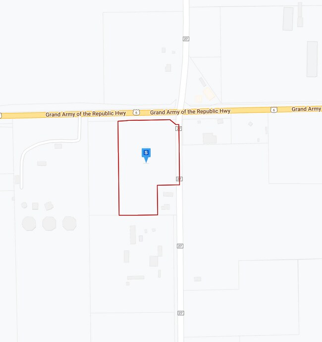
Us 6, Waterloo, IN 46793
Property Detail
Us 6
Auburn, IN
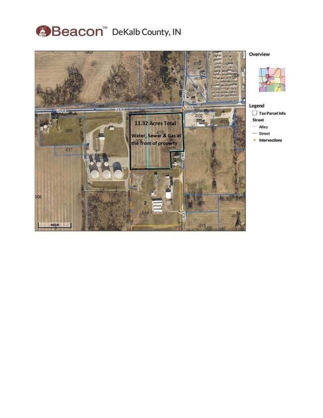
PT NE 1/4 SECTION 6 TWP 34 RANGE 13 ACRES 7.32
17-06-06-200-006.000-008
DEKALB
Agriculturalland
Indiana
B and X Area of moderate flood hazard, usually the area between the limits of the 100-year and 500-year floods.
4 AC
2025
Fort Wayne
2025
Other Market Areas
020100
NEARBY LISTINGS FOR SALE OR LEASE
DEMOGRAPHICS near Us 6
1 mile
3 mile
5 mile
2025 Total Population
78
3,732
13,899
2030 Population
79
3,872
14,344
Pop Growth 2025-2030
+ 1.28%
+ 3.75%
+ 3.20%
Average Age
43
40
41
2025 Total Households
30
1,389
5,575
HH Growth 2025-2030
0.00%
+ 3.53%
+ 3.10%
Median Household Inc
$85,000
$72,525
$69,779
Avg Household Size
2.50
2.50
2.40
2025 Avg HH Vehicles
2.00
2.00
2.00
Median Home Value
$274,999
$197,475
$191,903
Median Year Built
1979
1977
1981
Nearby Places
Map Layers
Map Styles
 Street
 Aerial
Layers
 Traffic
 Biking
Places
Listings with unknown addresses are not visible on the map
- Restaurants
- Banks
- Shops
- Fitness
- Groceries
PUBLIC TRANSPORTATION
COMMUTER RAIL
Waterloo Amtrak Station (Capitol Limited - Amtrak, Lake Shore Limited - Amtrak)
Drive
Walk
Distance
Waterloo Amtrak Station (Capitol Limited - Amtrak, Lake Shore Limited - Amtrak)
3 min
2.3 mi
Freight Ports
Port of Toledo
Drive
Walk
Distance
Port of Toledo
130 min
94.4 mi
SALE & LEASE HISTORY
LISTING DATE
SALE/LEASE

Apr 25, 2022
For Sale
Nearby Properties
Address
Land Use
TOTAL SIZE
Lot Size
Zoning
Address
Land Use
TOTAL SIZE
Lot Size
Zoning
30,342 SF
73.74 AC
Address
Land Use
TOTAL SIZE
Lot Size
Zoning
10,868 SF
40.25 AC
Address
Land Use
TOTAL SIZE
Lot Size
Zoning
207,160 SF
15.96 AC
Address
Land Use
TOTAL SIZE
Lot Size
Zoning
37,500 SF
15.91 AC
Address
Land Use
TOTAL SIZE
Lot Size
Zoning
11,461 SF
13.59 AC
Address
Land Use
TOTAL SIZE
Lot Size
Zoning
1,664 SF
32.70 AC
Address
Land Use
TOTAL SIZE
Lot Size
Zoning
21,600 SF
81.70 AC
Address
Land Use
TOTAL SIZE
Lot Size
Zoning
42,750 SF
10.10 AC
Address
Land Use
TOTAL SIZE
Lot Size
Zoning
3,832 SF
0.24 AC
Address
Land Use
TOTAL SIZE
Lot Size
Zoning
12,000 SF
5.19 AC
Address
Land Use
TOTAL SIZE
Lot Size
Zoning
16,000 SF
94.74 AC
Address
Land Use
TOTAL SIZE
Lot Size
Zoning
8,995 SF
1.36 AC
Address
Land Use
TOTAL SIZE
Lot Size
Zoning
41,440 SF
7 AC
Address
Land Use
TOTAL SIZE
Lot Size
Zoning
9,020 SF
1.18 AC
Address
Land Use
TOTAL SIZE
Lot Size
Zoning
72,000 SF
5.21 AC
Address
Land Use
TOTAL SIZE
Lot Size
Zoning
5,328 SF
4.40 AC
Address
Land Use
TOTAL SIZE
Lot Size
Zoning
76,200 SF
87 SF
Address
Land Use
TOTAL SIZE
Lot Size
Zoning
22,672 SF
4 AC
Address
Land Use
TOTAL SIZE
Lot Size
Zoning
6,167 SF
4.08 AC
Address
Land Use
TOTAL SIZE
Lot Size
Zoning
22,013 SF
4.52 AC
Address
Land Use
TOTAL SIZE
Lot Size
Zoning
15.81 AC
Address
Land Use
TOTAL SIZE
Lot Size
Zoning
11,424 SF
2.50 AC
Address
Land Use
TOTAL SIZE
Lot Size
Zoning
4,960 SF
12.64 AC
Address
Land Use
TOTAL SIZE
Lot Size
Zoning
4,320 SF
1.91 AC
Address
Land Use
TOTAL SIZE
Lot Size
Zoning
15,424 SF
23.90 AC
Address
Land Use
TOTAL SIZE
Lot Size
Zoning
149.05 AC
Address
Land Use
TOTAL SIZE
Lot Size
Zoning
31,500 SF
4.23 AC
Address
Land Use
TOTAL SIZE
Lot Size
Zoning
4,335 SF
10.87 AC
Address
Land Use
TOTAL SIZE
Lot Size
Zoning
576 SF
61.29 AC
Address
Land Use
TOTAL SIZE
Lot Size
Zoning
1,008 SF
19.98 AC
The World's #1 Commercial Real Estate Marketplace
Connect with us
© 2026 CoStar Group
The information above has been obtained from sources believed reliable. While we do not doubt its accuracy we have not verified it and make no guarantee, warranty or representation about it. It is your responsibility to independently confirm its accuracy and completeness. Any projections, opinions, assumptions, or estimates used are for example only and do not represent the current or future performance of the property. The value of this transaction to you depends on tax and other factors which should be evaluated by your tax, financial, and legal advisors. You and your advisors should conduct a careful, independent investigation of the property to determine to your satisfaction the suitability of the property for your needs.