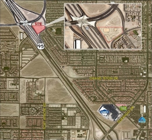
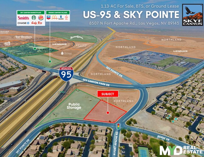
Property Record
8507 N Fort Apache Rd, Las Vegas, NV 89143


Property Detail
8507 N Fort Apache Rd
Las Vegas-Henderson-North Las Vegas, NV
SKY POINTE AND FORT APACHE STORAGE PLAT BOOK 170 PAGE 75 PT LOT 1
125-07-717-003
CLARK
Vacantlandnec
Nevada
B and X Area of moderate flood hazard, usually the area between the limits of the 100-year and 500-year floods.
1
2026
1.13 AC
2026
North Las Vegas
003316
Las Vegas
NEARBY LISTINGS FOR SALE OR LEASE
DEMOGRAPHICS near 8507 N Fort Apache Rd
1 mile
3 mile
5 mile
2025 Total Population
24,095
101,017
153,969
2030 Population
25,736
107,360
163,266
Pop Growth 2025-2030
+ 6.81%
+ 6.28%
+ 6.04%
Average Age
36
37
39
2025 Total Households
7,984
35,096
53,532
HH Growth 2025-2030
+ 6.79%
+ 6.30%
+ 6.08%
Median Household Inc
$98,609
$103,262
$108,209
Avg Household Size
3.00
2.80
2.80
2025 Avg HH Vehicles
2.00
2.00
2.00
Median Home Value
$491,999
$491,915
$544,827
Median Year Built
2007
2007
2005
Nearby Places
Map Layers
Map Styles
 Street
 Aerial
Layers
 Traffic
 Biking
Places
Listings with unknown addresses are not visible on the map
- Restaurants
- Banks
- Shops
- Fitness
- Groceries
PUBLIC TRANSPORTATION
AIRPORT
Harry Reid International
Drive
Walk
Distance
Harry Reid International
33 min
22.7 mi
Freight Ports
Port of Long Beach
Drive
Walk
Distance
Port of Long Beach
334 min
298.2 mi
SALE & LEASE HISTORY
LISTING DATE
SALE/LEASE

Sep 03, 2021
For Lease
May 15, 2024
For Sale
Mar 23, 2020
For Sale
Mar 18, 2020
For Sale
Nearby Properties
Address
Land Use
TOTAL SIZE
Lot Size
Zoning
Address
Land Use
TOTAL SIZE
Lot Size
Zoning
358,316 SF
35.74 AC
TC
Address
Land Use
TOTAL SIZE
Lot Size
Zoning
195,916 SF
5.91 AC
L:T-C
Address
Land Use
TOTAL SIZE
Lot Size
Zoning
27,487 SF
697.78 AC
CV
Address
Land Use
TOTAL SIZE
Lot Size
Zoning
20,943 SF
17.99 AC
PD
Address
Land Use
TOTAL SIZE
Lot Size
Zoning
704 SF
7.49 AC
Address
Land Use
TOTAL SIZE
Lot Size
Zoning
Address
Land Use
TOTAL SIZE
Lot Size
Zoning
140,690 SF
37.50 AC
CV
Address
Land Use
TOTAL SIZE
Lot Size
Zoning
9,415 SF
12.63 AC
Address
Land Use
TOTAL SIZE
Lot Size
Zoning
25 AC
RE
Address
Land Use
TOTAL SIZE
Lot Size
Zoning
Address
Land Use
TOTAL SIZE
Lot Size
Zoning
14.92 AC
UPROS
Address
Land Use
TOTAL SIZE
Lot Size
Zoning
43,952 SF
7.96 AC
Address
Land Use
TOTAL SIZE
Lot Size
Zoning
20 AC
CV
Address
Land Use
TOTAL SIZE
Lot Size
Zoning
172,927 SF
20.78 AC
TC
Address
Land Use
TOTAL SIZE
Lot Size
Zoning
12.42 AC
PF
Address
Land Use
TOTAL SIZE
Lot Size
Zoning
3,315 SF
13.23 AC
TC
Address
Land Use
TOTAL SIZE
Lot Size
Zoning
90,599 SF
12.14 AC
Address
Land Use
TOTAL SIZE
Lot Size
Zoning
2,224 SF
8.66 AC
TC
Address
Land Use
TOTAL SIZE
Lot Size
Zoning
30.06 AC
TC
Address
Land Use
TOTAL SIZE
Lot Size
Zoning
14.99 AC
PF
Address
Land Use
TOTAL SIZE
Lot Size
Zoning
101,611 SF
0.67 AC
TC
Address
Land Use
TOTAL SIZE
Lot Size
Zoning
55,385 SF
4 AC
Address
Land Use
TOTAL SIZE
Lot Size
Zoning
63,946 SF
10.30 AC
TC
Address
Land Use
TOTAL SIZE
Lot Size
Zoning
125,676 SF
11.98 AC
Address
Land Use
TOTAL SIZE
Lot Size
Zoning
98,538 SF
10.30 AC
TC
Address
Land Use
TOTAL SIZE
Lot Size
Zoning
72,654 SF
9.50 AC
Address
Land Use
TOTAL SIZE
Lot Size
Zoning
4,207 SF
3.51 AC
TC
Address
Land Use
TOTAL SIZE
Lot Size
Zoning
89,820 SF
8.41 AC
TC
Address
Land Use
TOTAL SIZE
Lot Size
Zoning
56,090 SF
5.48 AC
The World's #1 Commercial Real Estate Marketplace
Connect with us
© 2026 CoStar Group
The information above has been obtained from sources believed reliable. While we do not doubt its accuracy we have not verified it and make no guarantee, warranty or representation about it. It is your responsibility to independently confirm its accuracy and completeness. Any projections, opinions, assumptions, or estimates used are for example only and do not represent the current or future performance of the property. The value of this transaction to you depends on tax and other factors which should be evaluated by your tax, financial, and legal advisors. You and your advisors should conduct a careful, independent investigation of the property to determine to your satisfaction the suitability of the property for your needs.