Property Record
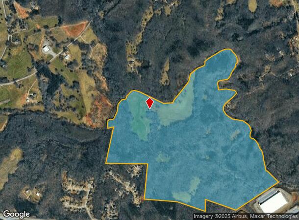
Us Highway 129 N, Talmo, GA 30575
NEARBY LISTINGS FOR SALE OR LEASE
Property Detail
Us Highway 129 N
101-008
TRACT 2 PLAT BOOK 60 PAGE 204
Agriculturalland
Jackson
A
Georgia
13139C0350G
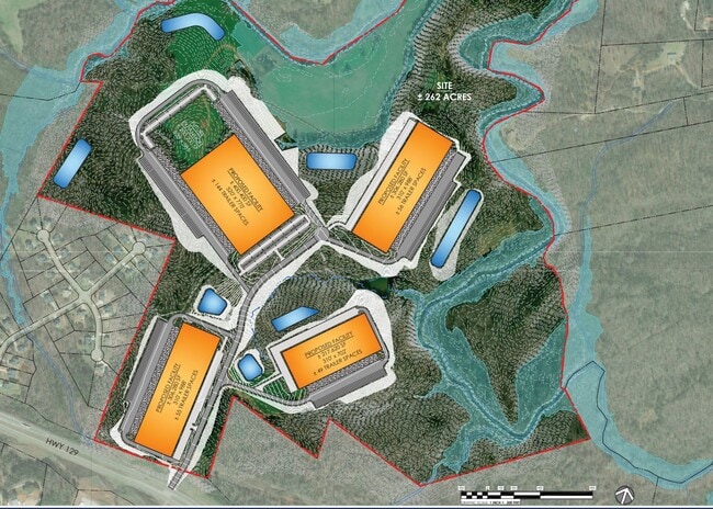
254.15 AC
2025
Braselton/W Jackson
2024
Atlanta
010104
Jefferson, GA
DEMOGRAPHICS near Us Highway 129 N
1 Mile
3 Mile
5 Mile
2024 Total Population
448
4,954
19,772
2029 Population
582
6,332
24,135
Pop Growth 2024-2029
+ 29.91%
+ 27.82%
+ 22.07%
Average Age
37
37
37
2024 Total Households
139
1,578
6,137
HH Growth 2024-2029
+ 28.78%
+ 26.49%
+ 21.74%
Median Household Inc
$57,999
$62,440
$64,660
Avg Household Size
3.20
3.10
3.10
2024 Avg HH Vehicles
2.00
2.00
2.00
Median Home Value
$361,363
$341,366
$289,672
Median Year Built
2003
2004
2001
Nearby Places
Map Layers
Map Styles
 Street
 Aerial
- Restaurants
- Banks
- Shops
- Fitness
- Groceries
SALE & LEASE HISTORY
LISTING DATE
SALE/LEASE

Aug 11, 2021
For Lease
Nearby Properties
Address
Land Use
TOTAL SIZE
Lot Size
Zoning
Address
Land Use
TOTAL SIZE
Lot Size
Zoning
474,720 SF
40.19 AC
A1
Address
Land Use
TOTAL SIZE
Lot Size
Zoning
1,002,252 SF
90.41 AC
R
Address
Land Use
TOTAL SIZE
Lot Size
Zoning
147,528 SF
21.80 AC
001
Address
Land Use
TOTAL SIZE
Lot Size
Zoning
801,420 SF
80.72 AC
L-I
Address
Land Use
TOTAL SIZE
Lot Size
Zoning
1,053,360 SF
101.96 AC
001
Address
Land Use
TOTAL SIZE
Lot Size
Zoning
517,500 SF
79.14 AC
R1
Address
Land Use
TOTAL SIZE
Lot Size
Zoning
1,120,106 SF
66.43 AC
Address
Land Use
TOTAL SIZE
Lot Size
Zoning
222,250 SF
37.52 AC
R
Address
Land Use
TOTAL SIZE
Lot Size
Zoning
358,560 SF
63.15 AC
P6
Address
Land Use
TOTAL SIZE
Lot Size
Zoning
92,004 SF
233.70 AC
001
Address
Land Use
TOTAL SIZE
Lot Size
Zoning
21.80 AC
001
Address
Land Use
TOTAL SIZE
Lot Size
Zoning
154,672 SF
15.50 AC
MI
Address
Land Use
TOTAL SIZE
Lot Size
Zoning
161,407 SF
21.51 AC
M1
Address
Land Use
TOTAL SIZE
Lot Size
Zoning
284.54 AC
002
Address
Land Use
TOTAL SIZE
Lot Size
Zoning
41,455 SF
25.48 AC
I-1
Address
Land Use
TOTAL SIZE
Lot Size
Zoning
23.70 AC
004
Address
Land Use
TOTAL SIZE
Lot Size
Zoning
23.70 AC
004
Address
Land Use
TOTAL SIZE
Lot Size
Zoning
1,800 SF
16.83 AC
MI
Address
Land Use
TOTAL SIZE
Lot Size
Zoning
91,188 SF
8.55 AC
003
Address
Land Use
TOTAL SIZE
Lot Size
Zoning
255.13 AC
004
Address
Land Use
TOTAL SIZE
Lot Size
Zoning
200.40 AC
A1
Address
Land Use
TOTAL SIZE
Lot Size
Zoning
2,340 SF
56.80 AC
A2
Address
Land Use
TOTAL SIZE
Lot Size
Zoning
201.24 AC
004
Address
Land Use
TOTAL SIZE
Lot Size
Zoning
197.28 AC
001
Address
Land Use
TOTAL SIZE
Lot Size
Zoning
111.96 AC
001
Address
Land Use
TOTAL SIZE
Lot Size
Zoning
1,890 SF
84.33 AC
003
Address
Land Use
TOTAL SIZE
Lot Size
Zoning
141.04 AC
AR-1
Address
Land Use
TOTAL SIZE
Lot Size
Zoning
16.93 AC
PID
Address
Land Use
TOTAL SIZE
Lot Size
Zoning
660 SF
115.23 AC
The World's #1 Commercial Real Estate Marketplace
Connect with us
© 2025 CoStar Group
The information above has been obtained from sources believed reliable. While we do not doubt its accuracy we have not verified it and make no guarantee, warranty or representation about it. It is your responsibility to independently confirm its accuracy and completeness. Any projections, opinions, assumptions, or estimates used are for example only and do not represent the current or future performance of the property. The value of this transaction to you depends on tax and other factors which should be evaluated by your tax, financial, and legal advisors. You and your advisors should conduct a careful, independent investigation of the property to determine to your satisfaction the suitability of the property for your needs.