Property Record
Us Highway 17 N, Bowling Green, FL 33834
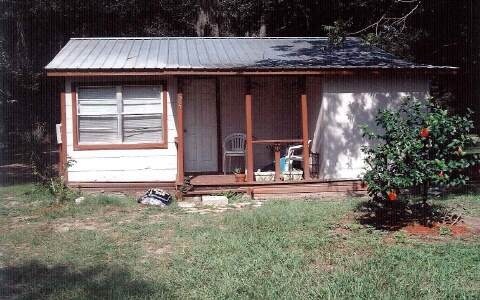


This Property Is For Sale
NEARBY LISTINGS FOR SALE OR LEASE
-
-
View all Bowling Green listings for sale on LoopNet.com
Property Detail
Us Highway 17 N
1733-25-0000-06540-0000
7.77 AC COM NW COR OF NE1/4 OF NE1/4 N 89D 26M 06S E ALONG N LINE OF NE1/4 OF NE1/4 226.43 FT FOR POB CONT N 89D 26M 06S E ALONG N LINE 941.62 FT TO PT ON W/LY R/W LINE OF SR 35 (AKA US HWY 17) S 07D 39M 17S W ALONG W/LY R/W LINE 373.84 FT S 89 26M 0
Farms
Hardee
X
Florida
12049C0177D
7.77 AC
2025
Florida Central South Area
2025
Other Market Areas
970202
Wauchula, FL
DEMOGRAPHICS near Us Highway 17 N
1 Mile
3 Mile
5 Mile
2024 Total Population
1,544
7,824
11,858
2029 Population
1,665
8,318
12,435
Pop Growth 2024-2029
+ 7.84%
+ 6.31%
+ 4.87%
Average Age
41
38
37
2024 Total Households
546
2,605
3,956
HH Growth 2024-2029
+ 7.88%
+ 6.37%
+ 4.95%
Median Household Inc
$50,659
$42,807
$43,333
Avg Household Size
2.80
3.00
3.00
2024 Avg HH Vehicles
2.00
2.00
2.00
Median Home Value
$89,867
$122,139
$131,481
Median Year Built
1987
1982
1979
Nearby Places
- Restaurants
- Banks
- Shops
- Fitness
- Groceries
Nearby Properties
Address
Land Use
TOTAL SIZE
Lot Size
Zoning
Address
Land Use
TOTAL SIZE
Lot Size
Zoning
60.50 AC
F-R
Address
Land Use
TOTAL SIZE
Lot Size
Zoning
6 AC
P-I
Address
Land Use
TOTAL SIZE
Lot Size
Zoning
122,608 SF
10.32 AC
R-3
Address
Land Use
TOTAL SIZE
Lot Size
Zoning
1,260 SF
39.68 AC
P-I
Address
Land Use
TOTAL SIZE
Lot Size
Zoning
31,216 SF
5.16 AC
C-2
Address
Land Use
TOTAL SIZE
Lot Size
Zoning
1,800 SF
138.30 AC
A-1
Address
Land Use
TOTAL SIZE
Lot Size
Zoning
1,224 SF
47.28 AC
A-1
Address
Land Use
TOTAL SIZE
Lot Size
Zoning
581.63 AC
A-1
Address
Land Use
TOTAL SIZE
Lot Size
Zoning
80,858 SF
8.63 AC
C/IBC
Address
Land Use
TOTAL SIZE
Lot Size
Zoning
68,254 SF
11 AC
R-3
Address
Land Use
TOTAL SIZE
Lot Size
Zoning
41,794 SF
4.07 AC
C/IBC
Address
Land Use
TOTAL SIZE
Lot Size
Zoning
36,053 SF
15.50 AC
C-2
Address
Land Use
TOTAL SIZE
Lot Size
Zoning
7,680 SF
181.93 AC
A-1
Address
Land Use
TOTAL SIZE
Lot Size
Zoning
173.72 AC
A-1
Address
Land Use
TOTAL SIZE
Lot Size
Zoning
1,864 SF
487.82 AC
A-1
Address
Land Use
TOTAL SIZE
Lot Size
Zoning
5,004 SF
162.50 AC
A-1
Address
Land Use
TOTAL SIZE
Lot Size
Zoning
52.50 AC
A-1
Address
Land Use
TOTAL SIZE
Lot Size
Zoning
11,332 SF
4.29 AC
P-R
Address
Land Use
TOTAL SIZE
Lot Size
Zoning
3,600 SF
615.10 AC
Address
Land Use
TOTAL SIZE
Lot Size
Zoning
53 AC
F-R
Address
Land Use
TOTAL SIZE
Lot Size
Zoning
85.85 AC
A-1
Address
Land Use
TOTAL SIZE
Lot Size
Zoning
9,056 SF
4.31 AC
C/IBC
Address
Land Use
TOTAL SIZE
Lot Size
Zoning
1,734 SF
98 AC
A-1
Address
Land Use
TOTAL SIZE
Lot Size
Zoning
80 AC
A-1
Address
Land Use
TOTAL SIZE
Lot Size
Zoning
5.06 AC
P-R
Address
Land Use
TOTAL SIZE
Lot Size
Zoning
16,375 SF
4.06 AC
C/IBC
Address
Land Use
TOTAL SIZE
Lot Size
Zoning
14,700 SF
97.50 AC
F-R
Address
Land Use
TOTAL SIZE
Lot Size
Zoning
27,510 SF
1.81 AC
R-1
Address
Land Use
TOTAL SIZE
Lot Size
Zoning
39.46 AC
A-1
Address
Land Use
TOTAL SIZE
Lot Size
Zoning
50.69 AC
A-1
The World's #1 Commercial Real Estate Marketplace
Connect with us
© 2025 CoStar Group
The information above has been obtained from sources believed reliable. While we do not doubt its accuracy we have not verified it and make no guarantee, warranty or representation about it. It is your responsibility to independently confirm its accuracy and completeness. Any projections, opinions, assumptions, or estimates used are for example only and do not represent the current or future performance of the property. The value of this transaction to you depends on tax and other factors which should be evaluated by your tax, financial, and legal advisors. You and your advisors should conduct a careful, independent investigation of the property to determine to your satisfaction the suitability of the property for your needs.