Property Record
Us Highway 17 N, Wauchula, FL 33873
NEARBY LISTINGS FOR SALE OR LEASE
-
-
View all Wauchula listings for sale on LoopNet.com
Property Detail
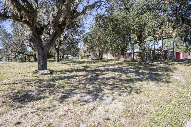
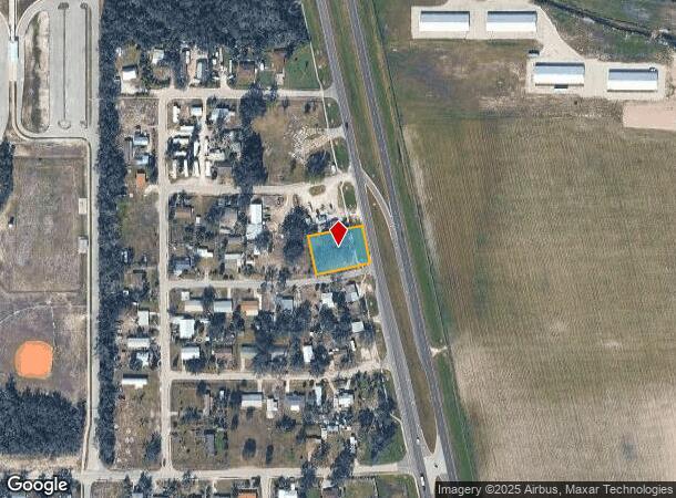
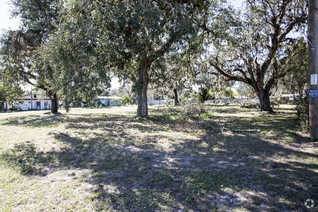
Us Highway 17 N
Wauchula, FL
Wauchula Hills Subd
2833-25-0820-00003-0016
S 20 FT OF LOT 16 & LOTS 17 18 & 19 BLK 3 WAUCHULA HILLS SUBD 28 33S 25E 129P3 410P512 200925007192- 7196 PMR/10-09/09000097CP/WRW 200925009073/DC-WRW 200925009073/DC-WRW/9074-AFF 201025004692-PET/4693-ORDR/ 4769 201725006549 201925005817
Commercialacreage
Hardee
X
Florida
12049C0179D
16
2025
0.32 AC
2025
Florida Central South Area
970301
Other Market Areas
DEMOGRAPHICS near Us Highway 17 N
1 Mile
3 Mile
5 Mile
2024 Total Population
2,020
9,023
16,892
2029 Population
2,121
9,305
17,554
Pop Growth 2024-2029
+ 5.00%
+ 3.13%
+ 3.92%
Average Age
39
37
37
2024 Total Households
704
3,034
5,607
HH Growth 2024-2029
+ 4.97%
+ 3.33%
+ 4.03%
Median Household Inc
$43,249
$37,865
$39,894
Avg Household Size
2.90
2.90
2.90
2024 Avg HH Vehicles
2.00
2.00
2.00
Median Home Value
$256,906
$152,771
$124,350
Median Year Built
1979
1978
1979
Nearby Places
Map Layers
Map Styles
 Street
 Aerial
- Restaurants
- Banks
- Shops
- Fitness
- Groceries
SALE & LEASE HISTORY
LISTING DATE
SALE/LEASE

May 15, 2017
For Sale
Nearby Properties
Address
Land Use
TOTAL SIZE
Lot Size
Zoning
Address
Land Use
TOTAL SIZE
Lot Size
Zoning
60.50 AC
F-R
Address
Land Use
TOTAL SIZE
Lot Size
Zoning
22.21 AC
P-SP
Address
Land Use
TOTAL SIZE
Lot Size
Zoning
47,399 SF
55.51 AC
C-2
Address
Land Use
TOTAL SIZE
Lot Size
Zoning
107,610 SF
14.32 AC
C-1
Address
Land Use
TOTAL SIZE
Lot Size
Zoning
122,608 SF
10.32 AC
R-3
Address
Land Use
TOTAL SIZE
Lot Size
Zoning
45,018 SF
17.48 AC
P-SP
Address
Land Use
TOTAL SIZE
Lot Size
Zoning
1,260 SF
39.68 AC
P-I
Address
Land Use
TOTAL SIZE
Lot Size
Zoning
104,690 SF
9.96 AC
F-R
Address
Land Use
TOTAL SIZE
Lot Size
Zoning
54,007 SF
9 AC
P-SP
Address
Land Use
TOTAL SIZE
Lot Size
Zoning
13.28 AC
F-R
Address
Land Use
TOTAL SIZE
Lot Size
Zoning
31,216 SF
5.16 AC
C-2
Address
Land Use
TOTAL SIZE
Lot Size
Zoning
1,224 SF
47.28 AC
A-1
Address
Land Use
TOTAL SIZE
Lot Size
Zoning
47,374 SF
1.79 AC
P-SP
Address
Land Use
TOTAL SIZE
Lot Size
Zoning
28.95 AC
P-SP
Address
Land Use
TOTAL SIZE
Lot Size
Zoning
432 SF
9.75 AC
P-SP
Address
Land Use
TOTAL SIZE
Lot Size
Zoning
581.63 AC
A-1
Address
Land Use
TOTAL SIZE
Lot Size
Zoning
2,708 SF
225.32 AC
A-1
Address
Land Use
TOTAL SIZE
Lot Size
Zoning
80,858 SF
8.63 AC
C/IBC
Address
Land Use
TOTAL SIZE
Lot Size
Zoning
35,140 SF
2.02 AC
P-SP
Address
Land Use
TOTAL SIZE
Lot Size
Zoning
53,214 SF
12.50 AC
R-1A
Address
Land Use
TOTAL SIZE
Lot Size
Zoning
425.01 AC
A-1
Address
Land Use
TOTAL SIZE
Lot Size
Zoning
68,254 SF
11 AC
R-3
Address
Land Use
TOTAL SIZE
Lot Size
Zoning
288.71 AC
A-1
Address
Land Use
TOTAL SIZE
Lot Size
Zoning
41,794 SF
4.07 AC
C/IBC
Address
Land Use
TOTAL SIZE
Lot Size
Zoning
38,275 SF
18.72 AC
C-2
Address
Land Use
TOTAL SIZE
Lot Size
Zoning
27,168 SF
3.62 AC
C-1
Address
Land Use
TOTAL SIZE
Lot Size
Zoning
29,145 SF
0.80 AC
HC-1
Address
Land Use
TOTAL SIZE
Lot Size
Zoning
97,776 SF
6.29 AC
I
Address
Land Use
TOTAL SIZE
Lot Size
Zoning
36,053 SF
15.50 AC
C-2
Address
Land Use
TOTAL SIZE
Lot Size
Zoning
62.17 AC
A-1
The World's #1 Commercial Real Estate Marketplace
Connect with us
© 2025 CoStar Group
The information above has been obtained from sources believed reliable. While we do not doubt its accuracy we have not verified it and make no guarantee, warranty or representation about it. It is your responsibility to independently confirm its accuracy and completeness. Any projections, opinions, assumptions, or estimates used are for example only and do not represent the current or future performance of the property. The value of this transaction to you depends on tax and other factors which should be evaluated by your tax, financial, and legal advisors. You and your advisors should conduct a careful, independent investigation of the property to determine to your satisfaction the suitability of the property for your needs.