Property Record
S Us Highway 181, San Antonio, TX 78223
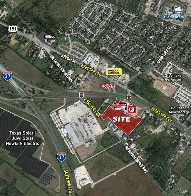
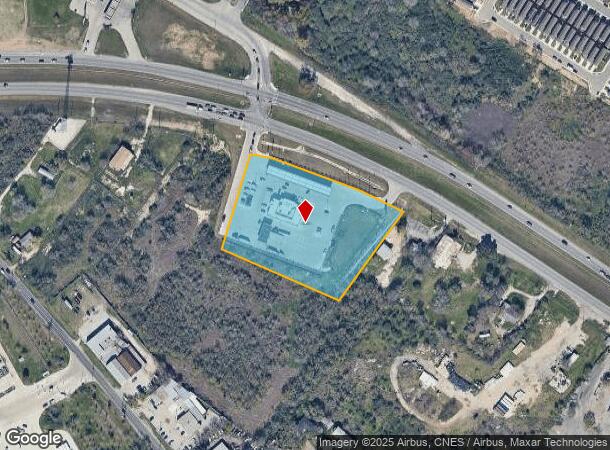
This Property Is For Sale
NEARBY LISTINGS FOR SALE OR LEASE
Property Detail
S Us Highway 181
San Antonio-New Braunfels, TX
Ncb 16623 (Qt 4052 Addition)
16623-025-0040
MCB 16623 BLK 25 LOT 4 (QT 4052 ADDITION) 2020-NEW PER PLAT 20001/1046 FILED 05-10-2019
Servicestation
Bexar
X
Texas
48029C0595G
4
2024
4.21 AC
2025
South
192200
San Antonio
47,140 SF
DEMOGRAPHICS near S Us Highway 181
1 Mile
3 Mile
5 Mile
2024 Total Population
3,584
14,560
51,360
2029 Population
4,049
16,083
55,649
Pop Growth 2024-2029
+ 12.97%
+ 10.46%
+ 8.35%
Average Age
36
36
36
2024 Total Households
1,198
4,652
17,529
HH Growth 2024-2029
+ 13.11%
+ 10.58%
+ 8.33%
Median Household Inc
$62,234
$69,954
$59,831
Avg Household Size
3.00
3.10
2.90
2024 Avg HH Vehicles
2.00
2.00
2.00
Median Home Value
$160,385
$189,875
$170,527
Median Year Built
1998
2003
2000
Nearby Places
Map Layers
Map Styles
 Street
 Aerial
- Restaurants
- Banks
- Shops
- Fitness
- Groceries
PUBLIC TRANSPORTATION
AIRPORT
San Antonio International
DRIVE
WALK
Distance
San Antonio International
23 min
18.3 mi
Freight Ports
Calhoun Port
DRIVE
WALK
Distance
Calhoun Port
172 min
141.5 mi
Nearby Properties
Address
Land Use
TOTAL SIZE
Lot Size
Zoning
Address
Land Use
TOTAL SIZE
Lot Size
Zoning
109,725 SF
48.90 AC
Address
Land Use
TOTAL SIZE
Lot Size
Zoning
189,001 SF
79.84 AC
Address
Land Use
TOTAL SIZE
Lot Size
Zoning
408,841 SF
32.70 AC
Address
Land Use
TOTAL SIZE
Lot Size
Zoning
6,756 SF
25 AC
Address
Land Use
TOTAL SIZE
Lot Size
Zoning
530,930 SF
37.45 AC
Address
Land Use
TOTAL SIZE
Lot Size
Zoning
31,627 SF
23.01 AC
Address
Land Use
TOTAL SIZE
Lot Size
Zoning
1,483 SF
165.84 AC
Address
Land Use
TOTAL SIZE
Lot Size
Zoning
7,160 SF
43.79 AC
Address
Land Use
TOTAL SIZE
Lot Size
Zoning
4,145 SF
86.75 AC
Address
Land Use
TOTAL SIZE
Lot Size
Zoning
78,028 SF
11.25 AC
Address
Land Use
TOTAL SIZE
Lot Size
Zoning
4,423 SF
217.83 AC
Address
Land Use
TOTAL SIZE
Lot Size
Zoning
904 SF
177.81 AC
Address
Land Use
TOTAL SIZE
Lot Size
Zoning
168.03 AC
Address
Land Use
TOTAL SIZE
Lot Size
Zoning
153.46 AC
Address
Land Use
TOTAL SIZE
Lot Size
Zoning
2,330 SF
46.28 AC
Address
Land Use
TOTAL SIZE
Lot Size
Zoning
1,056 SF
109.52 AC
Address
Land Use
TOTAL SIZE
Lot Size
Zoning
13,122 SF
24.15 AC
Address
Land Use
TOTAL SIZE
Lot Size
Zoning
13.97 AC
Address
Land Use
TOTAL SIZE
Lot Size
Zoning
124.20 AC
Address
Land Use
TOTAL SIZE
Lot Size
Zoning
2,550 SF
184.99 AC
Address
Land Use
TOTAL SIZE
Lot Size
Zoning
1,474 SF
8.59 AC
Address
Land Use
TOTAL SIZE
Lot Size
Zoning
77.85 AC
Address
Land Use
TOTAL SIZE
Lot Size
Zoning
52,700 SF
5.05 AC
Address
Land Use
TOTAL SIZE
Lot Size
Zoning
137.67 AC
Address
Land Use
TOTAL SIZE
Lot Size
Zoning
4,054 SF
147.28 AC
Address
Land Use
TOTAL SIZE
Lot Size
Zoning
43,608 SF
5.18 AC
Address
Land Use
TOTAL SIZE
Lot Size
Zoning
91,060 SF
12.71 AC
Address
Land Use
TOTAL SIZE
Lot Size
Zoning
119,755 SF
17.50 AC
Address
Land Use
TOTAL SIZE
Lot Size
Zoning
94,570 SF
2.86 AC
The World's #1 Commercial Real Estate Marketplace
Connect with us
© 2026 CoStar Group
The information above has been obtained from sources believed reliable. While we do not doubt its accuracy we have not verified it and make no guarantee, warranty or representation about it. It is your responsibility to independently confirm its accuracy and completeness. Any projections, opinions, assumptions, or estimates used are for example only and do not represent the current or future performance of the property. The value of this transaction to you depends on tax and other factors which should be evaluated by your tax, financial, and legal advisors. You and your advisors should conduct a careful, independent investigation of the property to determine to your satisfaction the suitability of the property for your needs.