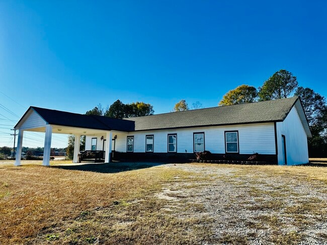
Property Record
Us Highway 19, Zebulon, GA 30295

Current Lease Availabilities
Property Detail
Us Highway 19
066-057
U S HWY 19
Religious
PIKE
RESIDENTIA
Georgia
B and X Area of moderate flood hazard, usually the area between the limits of the 100-year and 500-year floods.
2 AC
2025
Pike County
2025
Atlanta
010102
Atlanta-Sandy Springs-Roswell, GA
3,285 SF
NEARBY LISTINGS FOR SALE OR LEASE
DEMOGRAPHICS near Us Highway 19
1 mile
3 mile
5 mile
2025 Total Population
673
3,623
9,712
2030 Population
717
3,865
10,397
Pop Growth 2025-2030
+ 6.54%
+ 6.68%
+ 7.05%
Average Age
39
39
40
2025 Total Households
227
1,252
3,401
HH Growth 2025-2030
+ 6.61%
+ 6.55%
+ 6.85%
Median Household Inc
$73,055
$75,704
$86,371
Avg Household Size
2.70
2.70
2.80
2025 Avg HH Vehicles
2.00
2.00
3.00
Median Home Value
$314,286
$322,770
$329,048
Median Year Built
1989
1992
1994
Nearby Places
Map Layers
Map Styles
 Street
 Aerial
Layers
 Traffic
 Biking
Places
Listings with unknown addresses are not visible on the map
- Restaurants
- Banks
- Shops
- Fitness
- Groceries
Nearby Properties
Address
Land Use
TOTAL SIZE
Lot Size
Zoning
Address
Land Use
TOTAL SIZE
Lot Size
Zoning
94.92 AC
RESIDENTIA
Address
Land Use
TOTAL SIZE
Lot Size
Zoning
61,210 SF
11.21 AC
RESIDENTIA
Address
Land Use
TOTAL SIZE
Lot Size
Zoning
57.92 AC
RESIDENTIA
Address
Land Use
TOTAL SIZE
Lot Size
Zoning
43 AC
RESIDENTIA
Address
Land Use
TOTAL SIZE
Lot Size
Zoning
31.29 AC
RESIDENTIA
Address
Land Use
TOTAL SIZE
Lot Size
Zoning
50,004 SF
21.82 AC
RESIDENTIA
Address
Land Use
TOTAL SIZE
Lot Size
Zoning
22,626 SF
22.06 AC
RESIDENTIA
Address
Land Use
TOTAL SIZE
Lot Size
Zoning
16,625 SF
22.01 AC
Address
Land Use
TOTAL SIZE
Lot Size
Zoning
18,425 SF
1.21 AC
RESIDENTIA
Address
Land Use
TOTAL SIZE
Lot Size
Zoning
27,275 SF
10 AC
RESIDENTIA
Address
Land Use
TOTAL SIZE
Lot Size
Zoning
5,192 SF
4.97 AC
RESIDENTIA
Address
Land Use
TOTAL SIZE
Lot Size
Zoning
6,161 SF
95.52 AC
Address
Land Use
TOTAL SIZE
Lot Size
Zoning
19,390 SF
3.49 AC
RESIDENTIA
Address
Land Use
TOTAL SIZE
Lot Size
Zoning
21,820 SF
2.09 AC
RESIDENTIA
Address
Land Use
TOTAL SIZE
Lot Size
Zoning
27,500 SF
9.65 AC
Address
Land Use
TOTAL SIZE
Lot Size
Zoning
27,200 SF
16.12 AC
Address
Land Use
TOTAL SIZE
Lot Size
Zoning
9,603 SF
0.69 AC
RESIDENTIA
Address
Land Use
TOTAL SIZE
Lot Size
Zoning
5,000 SF
176.77 AC
RESIDENTIA
Address
Land Use
TOTAL SIZE
Lot Size
Zoning
238.60 AC
Address
Land Use
TOTAL SIZE
Lot Size
Zoning
24.58 AC
RESIDENTIA
Address
Land Use
TOTAL SIZE
Lot Size
Zoning
13,731 SF
2.50 AC
RESIDENTIA
Address
Land Use
TOTAL SIZE
Lot Size
Zoning
6,300 SF
2.29 AC
Address
Land Use
TOTAL SIZE
Lot Size
Zoning
5,856 SF
0.50 AC
RESIDENTIA
Address
Land Use
TOTAL SIZE
Lot Size
Zoning
5,824 SF
1.47 AC
RESIDENTIA
Address
Land Use
TOTAL SIZE
Lot Size
Zoning
7,369 SF
1.68 AC
RESIDENTIA
Address
Land Use
TOTAL SIZE
Lot Size
Zoning
162.82 AC
RESIDENTIA
Address
Land Use
TOTAL SIZE
Lot Size
Zoning
10,014 SF
3.27 AC
COMMERCIAL
Address
Land Use
TOTAL SIZE
Lot Size
Zoning
7,563 SF
2 AC
RESIDENTIA
Address
Land Use
TOTAL SIZE
Lot Size
Zoning
153.21 AC
Address
Land Use
TOTAL SIZE
Lot Size
Zoning
9,000 SF
2.36 AC
RESIDENTIA
The World's #1 Commercial Real Estate Marketplace
Connect with us
© 2026 CoStar Group
The information above has been obtained from sources believed reliable. While we do not doubt its accuracy we have not verified it and make no guarantee, warranty or representation about it. It is your responsibility to independently confirm its accuracy and completeness. Any projections, opinions, assumptions, or estimates used are for example only and do not represent the current or future performance of the property. The value of this transaction to you depends on tax and other factors which should be evaluated by your tax, financial, and legal advisors. You and your advisors should conduct a careful, independent investigation of the property to determine to your satisfaction the suitability of the property for your needs.