Property Record
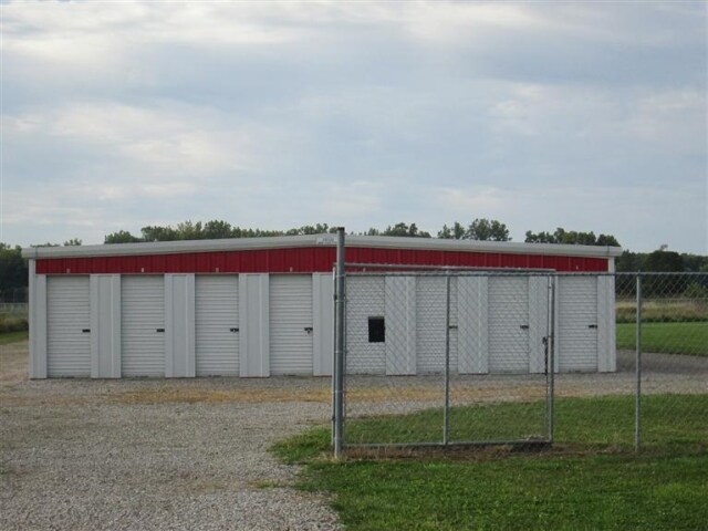
Us Highway 20 E, Collins, OH 44826

Property Detail
Us Highway 20 E
Norwalk, OH
SEC 1 PT OF LOT 86
48-0010-01-025-0200
HURON
Publicstorage
Ohio
B and X Area of moderate flood hazard, usually the area between the limits of the 100-year and 500-year floods.
86
2025
2.51 AC
2025
Huron County
915400
Cleveland
6,000 SF
NEARBY LISTINGS FOR SALE OR LEASE
-
-
View all Collins listings for sale on LoopNet.com
DEMOGRAPHICS near Us Highway 20 E
1 mile
3 mile
5 mile
2025 Total Population
160
2,039
5,506
2030 Population
156
1,996
5,368
Pop Growth 2025-2030
(2.50%)
(2.11%)
(2.51%)
Average Age
43
42
42
2025 Total Households
60
800
2,168
HH Growth 2025-2030
(1.67%)
(2.13%)
(2.58%)
Median Household Inc
$93,749
$72,867
$70,801
Avg Household Size
2.60
2.50
2.50
2025 Avg HH Vehicles
2.00
2.00
2.00
Median Home Value
$242,105
$216,492
$210,659
Median Year Built
1972
1970
1969
Nearby Places
Map Layers
Map Styles
 Street
 Aerial
Layers
 Traffic
 Biking
Places
Listings with unknown addresses are not visible on the map
- Restaurants
- Banks
- Shops
- Fitness
- Groceries
Nearby Properties
Address
Land Use
TOTAL SIZE
Lot Size
Zoning
Address
Land Use
TOTAL SIZE
Lot Size
Zoning
23,376 SF
14.03 AC
Address
Land Use
TOTAL SIZE
Lot Size
Zoning
48,394 SF
33.82 AC
Address
Land Use
TOTAL SIZE
Lot Size
Zoning
6,052 SF
235.30 AC
Address
Land Use
TOTAL SIZE
Lot Size
Zoning
16,500 SF
3 AC
Address
Land Use
TOTAL SIZE
Lot Size
Zoning
154.87 AC
Address
Land Use
TOTAL SIZE
Lot Size
Zoning
6,974 SF
44.50 AC
Address
Land Use
TOTAL SIZE
Lot Size
Zoning
Address
Land Use
TOTAL SIZE
Lot Size
Zoning
1,510 SF
100.25 AC
Address
Land Use
TOTAL SIZE
Lot Size
Zoning
1,715 SF
140.16 AC
Address
Land Use
TOTAL SIZE
Lot Size
Zoning
2,498 SF
52.62 AC
Address
Land Use
TOTAL SIZE
Lot Size
Zoning
2,368 SF
97 AC
Address
Land Use
TOTAL SIZE
Lot Size
Zoning
7,000 SF
5.66 AC
Address
Land Use
TOTAL SIZE
Lot Size
Zoning
896 SF
102 AC
Address
Land Use
TOTAL SIZE
Lot Size
Zoning
1,260 SF
71.42 AC
Address
Land Use
TOTAL SIZE
Lot Size
Zoning
1,224 SF
68.21 AC
Address
Land Use
TOTAL SIZE
Lot Size
Zoning
105.75 AC
Address
Land Use
TOTAL SIZE
Lot Size
Zoning
2,176 SF
68.22 AC
Address
Land Use
TOTAL SIZE
Lot Size
Zoning
1,456 SF
80 AC
Address
Land Use
TOTAL SIZE
Lot Size
Zoning
2,520 SF
56 AC
Address
Land Use
TOTAL SIZE
Lot Size
Zoning
99.52 AC
Address
Land Use
TOTAL SIZE
Lot Size
Zoning
94.62 AC
Address
Land Use
TOTAL SIZE
Lot Size
Zoning
99.40 AC
Address
Land Use
TOTAL SIZE
Lot Size
Zoning
2,540 SF
90.75 AC
Address
Land Use
TOTAL SIZE
Lot Size
Zoning
92.50 AC
Address
Land Use
TOTAL SIZE
Lot Size
Zoning
94 AC
Address
Land Use
TOTAL SIZE
Lot Size
Zoning
1,446 SF
97.53 AC
Address
Land Use
TOTAL SIZE
Lot Size
Zoning
1,232 SF
65.48 AC
Address
Land Use
TOTAL SIZE
Lot Size
Zoning
76.54 AC
Address
Land Use
TOTAL SIZE
Lot Size
Zoning
1,648 SF
79.25 AC
Address
Land Use
TOTAL SIZE
Lot Size
Zoning
2,248 SF
97.50 AC
The World's #1 Commercial Real Estate Marketplace
Connect with us
© 2026 CoStar Group
The information above has been obtained from sources believed reliable. While we do not doubt its accuracy we have not verified it and make no guarantee, warranty or representation about it. It is your responsibility to independently confirm its accuracy and completeness. Any projections, opinions, assumptions, or estimates used are for example only and do not represent the current or future performance of the property. The value of this transaction to you depends on tax and other factors which should be evaluated by your tax, financial, and legal advisors. You and your advisors should conduct a careful, independent investigation of the property to determine to your satisfaction the suitability of the property for your needs.