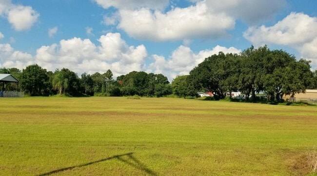
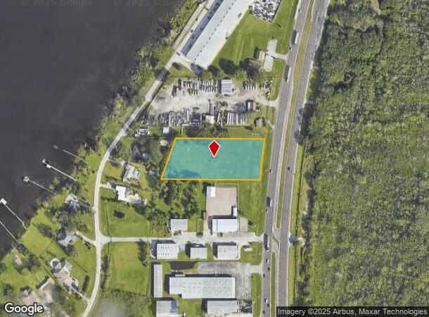
Property Record
Us Highway 27, Haines City, FL 33844
NEARBY LISTINGS FOR SALE OR LEASE
Property Detail
Us Highway 27
Tampa/St Petersburg
Hyer Hunter Prop
Lakeland-Winter Haven, FL
BEG AT INT OF N BNDRY OF SEC WITH WLY R/W OF US HWY 27 RUN N89-54W ALONG N BNDRY OF SEC 441.77 FT S19-06W 211.65 FT N89-54E 486.85 FT TO WLY R/W OF US HWY 27 NLY ALONG WLY R/W 200 FT TO POB
27-28-20-000000-031030
Polk
Commercialacreage
Florida
2024
2.12 AC
2025
Polk County
012701
DEMOGRAPHICS near Us Highway 27
1 Mile
3 Mile
5 Mile
2024 Total Population
2,744
17,560
29,713
2029 Population
3,318
21,128
35,755
Pop Growth 2024-2029
+ 20.92%
+ 20.32%
+ 20.33%
Average Age
38
40
41
2024 Total Households
1,077
6,834
11,686
HH Growth 2024-2029
+ 20.89%
+ 20.25%
+ 20.26%
Median Household Inc
$30,536
$42,483
$46,808
Avg Household Size
2.30
2.50
2.50
2024 Avg HH Vehicles
1.00
2.00
2.00
Median Home Value
$154,761
$171,798
$168,398
Median Year Built
1975
1977
1982
Nearby Places
Map Layers
Map Styles
 Street
 Aerial
- Restaurants
- Banks
- Shops
- Fitness
- Groceries
PUBLIC TRANSPORTATION
COMMUTER RAIL
Winter Haven (Silver Meteor - Amtrak, Silver Star - Amtrak)
DRIVE
WALK
Distance
Winter Haven (Silver Meteor - Amtrak, Silver Star - Amtrak)
17 min
9.3 mi
Freight Ports
Port of Tampa Bay
DRIVE
WALK
Distance
Port of Tampa Bay
82 min
58.3 mi
SALE & LEASE HISTORY
LISTING DATE
SALE/LEASE

Oct 19, 2020
For Sale
Nearby Properties
Address
Land Use
TOTAL SIZE
Lot Size
Zoning
Address
Land Use
TOTAL SIZE
Lot Size
Zoning
807,937 SF
72.45 AC
Address
Land Use
TOTAL SIZE
Lot Size
Zoning
175,423 SF
47.09 AC
XX
Address
Land Use
TOTAL SIZE
Lot Size
Zoning
138,111 SF
40.01 AC
RC
Address
Land Use
TOTAL SIZE
Lot Size
Zoning
104,120 SF
19.25 AC
Address
Land Use
TOTAL SIZE
Lot Size
Zoning
240,920 SF
15.33 AC
AG
Address
Land Use
TOTAL SIZE
Lot Size
Zoning
147,825 SF
10.23 AC
Address
Land Use
TOTAL SIZE
Lot Size
Zoning
33,156 SF
9.57 AC
RC
Address
Land Use
TOTAL SIZE
Lot Size
Zoning
72,928 SF
4.73 AC
Address
Land Use
TOTAL SIZE
Lot Size
Zoning
85,890 SF
7.75 AC
C1
Address
Land Use
TOTAL SIZE
Lot Size
Zoning
35,632 SF
29.34 AC
RC
Address
Land Use
TOTAL SIZE
Lot Size
Zoning
100,177 SF
12.39 AC
XX
Address
Land Use
TOTAL SIZE
Lot Size
Zoning
74,292 SF
14.62 AC
Address
Land Use
TOTAL SIZE
Lot Size
Zoning
21,510 SF
29 AC
RC
Address
Land Use
TOTAL SIZE
Lot Size
Zoning
34,063 SF
21.84 AC
R1A
Address
Land Use
TOTAL SIZE
Lot Size
Zoning
17,441 SF
119.40 AC
RC
Address
Land Use
TOTAL SIZE
Lot Size
Zoning
31,565 SF
2.19 AC
Address
Land Use
TOTAL SIZE
Lot Size
Zoning
112.61 AC
XX
Address
Land Use
TOTAL SIZE
Lot Size
Zoning
33,300 SF
8.94 AC
RC
Address
Land Use
TOTAL SIZE
Lot Size
Zoning
22,069 SF
7.74 AC
R1A
Address
Land Use
TOTAL SIZE
Lot Size
Zoning
189,241 SF
3.59 AC
C3
Address
Land Use
TOTAL SIZE
Lot Size
Zoning
70,000 SF
8.06 AC
C4
Address
Land Use
TOTAL SIZE
Lot Size
Zoning
33,962 SF
6.88 AC
C4
Address
Land Use
TOTAL SIZE
Lot Size
Zoning
5,544 SF
2.18 AC
XX
Address
Land Use
TOTAL SIZE
Lot Size
Zoning
27,754 SF
14.34 AC
RC
Address
Land Use
TOTAL SIZE
Lot Size
Zoning
864 SF
26.14 AC
XX
Address
Land Use
TOTAL SIZE
Lot Size
Zoning
15,400 SF
15.61 AC
Address
Land Use
TOTAL SIZE
Lot Size
Zoning
88.49 AC
RC
Address
Land Use
TOTAL SIZE
Lot Size
Zoning
24.30 AC
Address
Land Use
TOTAL SIZE
Lot Size
Zoning
12,402 SF
3.20 AC
Address
Land Use
TOTAL SIZE
Lot Size
Zoning
60,220 SF
12.05 AC
AG
The World's #1 Commercial Real Estate Marketplace
Connect with us
© 2025 CoStar Group
The information above has been obtained from sources believed reliable. While we do not doubt its accuracy we have not verified it and make no guarantee, warranty or representation about it. It is your responsibility to independently confirm its accuracy and completeness. Any projections, opinions, assumptions, or estimates used are for example only and do not represent the current or future performance of the property. The value of this transaction to you depends on tax and other factors which should be evaluated by your tax, financial, and legal advisors. You and your advisors should conduct a careful, independent investigation of the property to determine to your satisfaction the suitability of the property for your needs.