Property Record
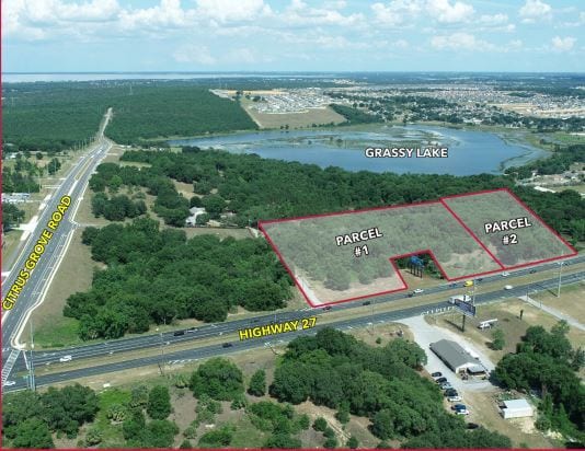
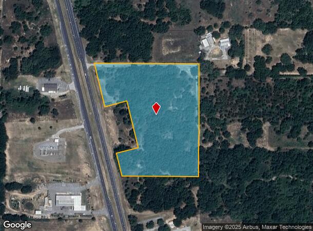
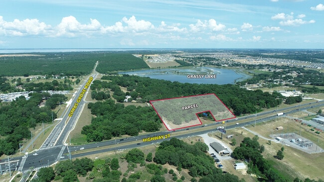
Us Highway 27, Minneola, FL 34715
This Property Is For Sale
NEARBY LISTINGS FOR SALE OR LEASE
Property Detail
Us Highway 27
Orlando-Kissimmee-Sanford, FL
BEG AT SE COR OF NW 1/4 OF SW 1/4 RUN N 00DEG 09MIN 20SEC E 751.72 FT TO S LINE OF N 570 FT OF SAID NW 1/4 OF SW 1/4 N 89DEG 50MIN 01SEC W 704.47 FT TO ELY R/W LINE OF SR 25 S 14DEG 00MIN 27SEC E ALONG SAID ELY R/W LINE 307.47 FT TO NWLY COR OF DEPAR
06-22-26-0003-000-04700
Lake
Commercialacreage
Florida
X
47
12069C0560E
9.38 AC
2024
Lake County
2026
Orlando
031309
DEMOGRAPHICS near Us Highway 27
1 Mile
3 Mile
5 Mile
2024 Total Population
4,621
34,454
71,512
2029 Population
5,418
40,655
83,956
Pop Growth 2024-2029
+ 17.25%
+ 18.00%
+ 17.40%
Average Age
39
41
41
2024 Total Households
1,588
12,221
25,861
HH Growth 2024-2029
+ 16.94%
+ 17.73%
+ 17.15%
Median Household Inc
$86,387
$84,512
$81,216
Avg Household Size
2.90
2.70
2.70
2024 Avg HH Vehicles
2.00
2.00
2.00
Median Home Value
$305,957
$329,923
$320,407
Median Year Built
2003
2006
2004
Nearby Places
Map Layers
Map Styles
 Street
 Aerial
- Restaurants
- Banks
- Shops
- Fitness
- Groceries
PUBLIC TRANSPORTATION
AIRPORT
Orlando International
DRIVE
WALK
Distance
Orlando International
48 min
35.3 mi
Freight Ports
Port of Tampa Bay
DRIVE
WALK
Distance
Port of Tampa Bay
106 min
78.8 mi
Nearby Properties
Address
Land Use
TOTAL SIZE
Lot Size
Zoning
Address
Land Use
TOTAL SIZE
Lot Size
Zoning
403,970 SF
30.99 AC
PUD
Address
Land Use
TOTAL SIZE
Lot Size
Zoning
337,218 SF
16.38 AC
Address
Land Use
TOTAL SIZE
Lot Size
Zoning
83.86 AC
Address
Land Use
TOTAL SIZE
Lot Size
Zoning
2,000 SF
63.78 AC
Address
Land Use
TOTAL SIZE
Lot Size
Zoning
203,762 SF
18.28 AC
R1
Address
Land Use
TOTAL SIZE
Lot Size
Zoning
80,774 SF
6.61 AC
Address
Land Use
TOTAL SIZE
Lot Size
Zoning
128,174 SF
9.88 AC
B1
Address
Land Use
TOTAL SIZE
Lot Size
Zoning
80,546 SF
6.75 AC
B1
Address
Land Use
TOTAL SIZE
Lot Size
Zoning
62,415 SF
10.19 AC
Address
Land Use
TOTAL SIZE
Lot Size
Zoning
74,375 SF
6.69 AC
Address
Land Use
TOTAL SIZE
Lot Size
Zoning
123,387 SF
47.51 AC
R3
Address
Land Use
TOTAL SIZE
Lot Size
Zoning
55,754 SF
9.14 AC
R2
Address
Land Use
TOTAL SIZE
Lot Size
Zoning
2,000 SF
19.45 AC
Address
Land Use
TOTAL SIZE
Lot Size
Zoning
30,926 SF
0.38 AC
Address
Land Use
TOTAL SIZE
Lot Size
Zoning
73,040 SF
4.89 AC
I1
Address
Land Use
TOTAL SIZE
Lot Size
Zoning
40,798 SF
7.51 AC
P
Address
Land Use
TOTAL SIZE
Lot Size
Zoning
102,584 SF
9.21 AC
R3
Address
Land Use
TOTAL SIZE
Lot Size
Zoning
28,836 SF
2.34 AC
Address
Land Use
TOTAL SIZE
Lot Size
Zoning
28,560 SF
9.89 AC
PUD
Address
Land Use
TOTAL SIZE
Lot Size
Zoning
30.07 AC
Address
Land Use
TOTAL SIZE
Lot Size
Zoning
14,106 SF
1.69 AC
RSF2
Address
Land Use
TOTAL SIZE
Lot Size
Zoning
2,000 SF
17.63 AC
P
Address
Land Use
TOTAL SIZE
Lot Size
Zoning
2,000 SF
20.63 AC
R1
Address
Land Use
TOTAL SIZE
Lot Size
Zoning
31,018 SF
2.88 AC
B1
Address
Land Use
TOTAL SIZE
Lot Size
Zoning
51,272 SF
4.91 AC
C2
Address
Land Use
TOTAL SIZE
Lot Size
Zoning
36,768 SF
3.59 AC
P
Address
Land Use
TOTAL SIZE
Lot Size
Zoning
23,504 SF
11.97 AC
CFD
Address
Land Use
TOTAL SIZE
Lot Size
Zoning
17,500 SF
2.05 AC
C2
Address
Land Use
TOTAL SIZE
Lot Size
Zoning
14,729 SF
1.95 AC
B1
Address
Land Use
TOTAL SIZE
Lot Size
Zoning
40.73 AC
R1
The World's #1 Commercial Real Estate Marketplace
Connect with us
© 2025 CoStar Group
The information above has been obtained from sources believed reliable. While we do not doubt its accuracy we have not verified it and make no guarantee, warranty or representation about it. It is your responsibility to independently confirm its accuracy and completeness. Any projections, opinions, assumptions, or estimates used are for example only and do not represent the current or future performance of the property. The value of this transaction to you depends on tax and other factors which should be evaluated by your tax, financial, and legal advisors. You and your advisors should conduct a careful, independent investigation of the property to determine to your satisfaction the suitability of the property for your needs.