Property Record
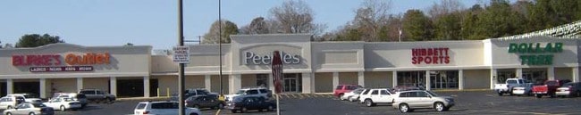
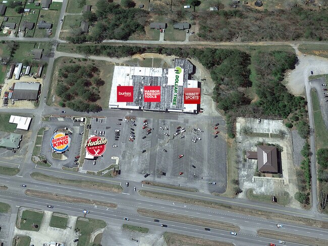
Us Highway 43, Russellville, AL 35653

NEARBY LISTINGS FOR SALE OR LEASE
-
-
View all Russellville listings for lease on LoopNet.com
Property Detail
Us Highway 43
02-04-20-3-000-055.024-0
009999
Storebuilding
E2 OF SW4 OF SEC 20 T6 R11 COM AT INT OF N ROW OF LINDEN ST AND W ROW OF U S HWY 43 TH N ALONG U S HWY 43 TH W ALG LINDEN ST
X
Franklin
01059C0114C
Alabama
2025
7.38 AC
2025
Alabama North Area
973200
Other Market Areas
61,778 SF
Russellville, AL
DEMOGRAPHICS near Us Highway 43
1 Mile
3 Mile
5 Mile
2024 Total Population
4,125
11,978
15,416
2029 Population
4,029
11,794
15,235
Pop Growth 2024-2029
(2.33%)
(1.54%)
(1.17%)
Average Age
35
37
37
2024 Total Households
1,381
4,216
5,487
HH Growth 2024-2029
(2.17%)
(1.38%)
(1.04%)
Median Household Inc
$41,951
$43,506
$44,457
Avg Household Size
2.80
2.70
2.70
2024 Avg HH Vehicles
2.00
2.00
2.00
Median Home Value
$85,401
$107,358
$119,461
Median Year Built
1973
1977
1980
Nearby Places
Map Layers
Map Styles
 Street
 Aerial
- Restaurants
- Banks
- Shops
- Fitness
- Groceries
SALE & LEASE HISTORY
LISTING DATE
SALE/LEASE

Oct 09, 2020
For Lease
Feb 01, 2021
For Lease
Aug 31, 2022
For Lease
Nearby Properties
Address
Land Use
TOTAL SIZE
Lot Size
Zoning
Address
Land Use
TOTAL SIZE
Lot Size
Zoning
50,492 SF
0.17 AC
Address
Land Use
TOTAL SIZE
Lot Size
Zoning
157,691 SF
19.41 AC
Address
Land Use
TOTAL SIZE
Lot Size
Zoning
24.86 AC
Address
Land Use
TOTAL SIZE
Lot Size
Zoning
12,729 SF
2.01 AC
Address
Land Use
TOTAL SIZE
Lot Size
Zoning
108,575 SF
4 AC
Address
Land Use
TOTAL SIZE
Lot Size
Zoning
111,006 SF
17.50 AC
Address
Land Use
TOTAL SIZE
Lot Size
Zoning
8,750 SF
30.88 AC
Address
Land Use
TOTAL SIZE
Lot Size
Zoning
5,000 SF
10 AC
Address
Land Use
TOTAL SIZE
Lot Size
Zoning
23,277 SF
1.01 AC
Address
Land Use
TOTAL SIZE
Lot Size
Zoning
12,158 SF
0.28 AC
Address
Land Use
TOTAL SIZE
Lot Size
Zoning
46,066 SF
4.27 AC
Address
Land Use
TOTAL SIZE
Lot Size
Zoning
320,933 SF
32.50 AC
Address
Land Use
TOTAL SIZE
Lot Size
Zoning
5,511 SF
3.49 AC
Address
Land Use
TOTAL SIZE
Lot Size
Zoning
10,769 SF
1.84 AC
Address
Land Use
TOTAL SIZE
Lot Size
Zoning
8,944 SF
8.27 AC
Address
Land Use
TOTAL SIZE
Lot Size
Zoning
9,487 SF
0.66 AC
Address
Land Use
TOTAL SIZE
Lot Size
Zoning
17,348 SF
2.68 AC
Address
Land Use
TOTAL SIZE
Lot Size
Zoning
1,000 SF
2.20 AC
Address
Land Use
TOTAL SIZE
Lot Size
Zoning
7,774 SF
1.72 AC
Address
Land Use
TOTAL SIZE
Lot Size
Zoning
4,082 SF
1 AC
Address
Land Use
TOTAL SIZE
Lot Size
Zoning
2,089 SF
6.50 AC
Address
Land Use
TOTAL SIZE
Lot Size
Zoning
26,600 SF
2.41 AC
Address
Land Use
TOTAL SIZE
Lot Size
Zoning
13,285 SF
2.71 AC
Address
Land Use
TOTAL SIZE
Lot Size
Zoning
12,501 SF
5 AC
Address
Land Use
TOTAL SIZE
Lot Size
Zoning
11,518 SF
2 AC
Address
Land Use
TOTAL SIZE
Lot Size
Zoning
13,766 SF
2.31 AC
Address
Land Use
TOTAL SIZE
Lot Size
Zoning
10,087 SF
5.77 AC
Address
Land Use
TOTAL SIZE
Lot Size
Zoning
49,790 SF
11.30 AC
Address
Land Use
TOTAL SIZE
Lot Size
Zoning
14,340 SF
0.85 AC
The World's #1 Commercial Real Estate Marketplace
Connect with us
© 2026 CoStar Group
The information above has been obtained from sources believed reliable. While we do not doubt its accuracy we have not verified it and make no guarantee, warranty or representation about it. It is your responsibility to independently confirm its accuracy and completeness. Any projections, opinions, assumptions, or estimates used are for example only and do not represent the current or future performance of the property. The value of this transaction to you depends on tax and other factors which should be evaluated by your tax, financial, and legal advisors. You and your advisors should conduct a careful, independent investigation of the property to determine to your satisfaction the suitability of the property for your needs.