Property Record
Us Highway 431, Guntersville, AL 35976


NEARBY LISTINGS FOR SALE OR LEASE
-
-
View all Guntersville listings for sale on LoopNet.com
Property Detail
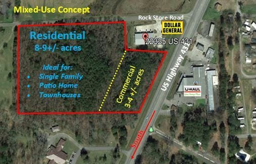
Us Highway 431
Albertville, AL
Tbg Subdivision
100624-0-002-017000
LOT 2-3 REDIVISION OF LOT 2 OF TBG SUBDIVISION 8/430-431 24/T7S/R3E 1434/202 3308/179 ORDINANCE
Commercialacreage
Marshall
X
Alabama
01095C0192D
2-3
2025
12.45 AC
2024
Alabama North Area
030602
Other Market Areas
DEMOGRAPHICS near Us Highway 431
1 Mile
3 Mile
5 Mile
2024 Total Population
883
2,834
6,476
2029 Population
942
3,045
6,915
Pop Growth 2024-2029
+ 6.68%
+ 7.45%
+ 6.78%
Average Age
49
48
46
2024 Total Households
362
1,180
2,680
HH Growth 2024-2029
+ 6.91%
+ 7.54%
+ 6.83%
Median Household Inc
$62,187
$65,442
$63,110
Avg Household Size
2.20
2.20
2.20
2024 Avg HH Vehicles
2.00
2.00
2.00
Median Home Value
$363,491
$325,324
$288,781
Median Year Built
2001
2000
1994
Nearby Places
Map Layers
Map Styles
 Street
 Aerial
- Restaurants
- Banks
- Shops
- Fitness
- Groceries
SALE & LEASE HISTORY
LISTING DATE
SALE/LEASE

Dec 20, 2019
For Sale
Nearby Properties
Address
Land Use
TOTAL SIZE
Lot Size
Zoning
Address
Land Use
TOTAL SIZE
Lot Size
Zoning
30,120 SF
3.35 AC
Address
Land Use
TOTAL SIZE
Lot Size
Zoning
9,955 SF
27.13 AC
Address
Land Use
TOTAL SIZE
Lot Size
Zoning
37,446 SF
6 AC
Address
Land Use
TOTAL SIZE
Lot Size
Zoning
Address
Land Use
TOTAL SIZE
Lot Size
Zoning
7,456 SF
48 AC
Address
Land Use
TOTAL SIZE
Lot Size
Zoning
21.18 AC
Address
Land Use
TOTAL SIZE
Lot Size
Zoning
12,263 SF
10.60 AC
Address
Land Use
TOTAL SIZE
Lot Size
Zoning
2,800 SF
5.14 AC
Address
Land Use
TOTAL SIZE
Lot Size
Zoning
14,794 SF
1.30 AC
Address
Land Use
TOTAL SIZE
Lot Size
Zoning
15,840 SF
12 AC
Address
Land Use
TOTAL SIZE
Lot Size
Zoning
3,224 SF
2.48 AC
Address
Land Use
TOTAL SIZE
Lot Size
Zoning
7,719 SF
2.88 AC
Address
Land Use
TOTAL SIZE
Lot Size
Zoning
8,400 SF
4.40 AC
Address
Land Use
TOTAL SIZE
Lot Size
Zoning
Address
Land Use
TOTAL SIZE
Lot Size
Zoning
20,580 SF
4 AC
Address
Land Use
TOTAL SIZE
Lot Size
Zoning
3,000 SF
297 AC
Address
Land Use
TOTAL SIZE
Lot Size
Zoning
7,438 SF
8.25 AC
Address
Land Use
TOTAL SIZE
Lot Size
Zoning
2.10 AC
Address
Land Use
TOTAL SIZE
Lot Size
Zoning
7,900 SF
1.41 AC
Address
Land Use
TOTAL SIZE
Lot Size
Zoning
10,000 SF
1.30 AC
Address
Land Use
TOTAL SIZE
Lot Size
Zoning
2,466 SF
6.23 AC
Address
Land Use
TOTAL SIZE
Lot Size
Zoning
27,420 SF
10 AC
Address
Land Use
TOTAL SIZE
Lot Size
Zoning
984 SF
33.25 AC
Address
Land Use
TOTAL SIZE
Lot Size
Zoning
2.96 AC
Address
Land Use
TOTAL SIZE
Lot Size
Zoning
Address
Land Use
TOTAL SIZE
Lot Size
Zoning
0.42 AC
Address
Land Use
TOTAL SIZE
Lot Size
Zoning
5.85 AC
Address
Land Use
TOTAL SIZE
Lot Size
Zoning
9,120 SF
79 AC
Address
Land Use
TOTAL SIZE
Lot Size
Zoning
9,600 SF
0.58 AC
Address
Land Use
TOTAL SIZE
Lot Size
Zoning
The World's #1 Commercial Real Estate Marketplace
Connect with us
© 2026 CoStar Group
The information above has been obtained from sources believed reliable. While we do not doubt its accuracy we have not verified it and make no guarantee, warranty or representation about it. It is your responsibility to independently confirm its accuracy and completeness. Any projections, opinions, assumptions, or estimates used are for example only and do not represent the current or future performance of the property. The value of this transaction to you depends on tax and other factors which should be evaluated by your tax, financial, and legal advisors. You and your advisors should conduct a careful, independent investigation of the property to determine to your satisfaction the suitability of the property for your needs.