Property Record
Us Highway 69, Bells, TX 75414
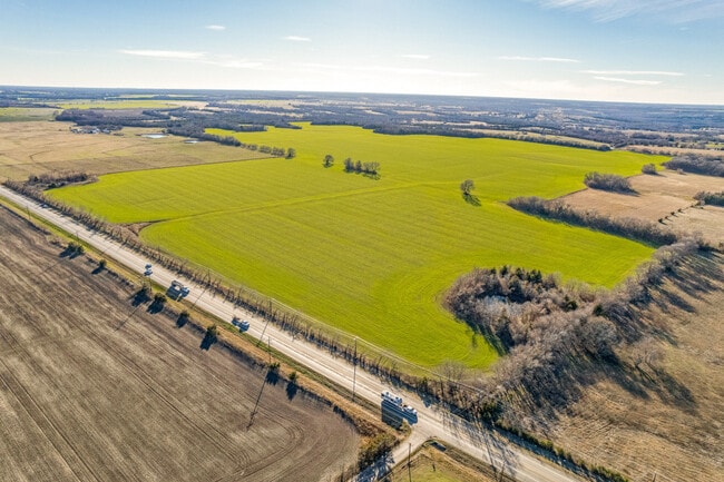
Property Detail
Us Highway 69
Sherman-Denison, TX
G-0265 CORNEAL P T A-G0265, ACRES 9.162
126841
GRAYSON
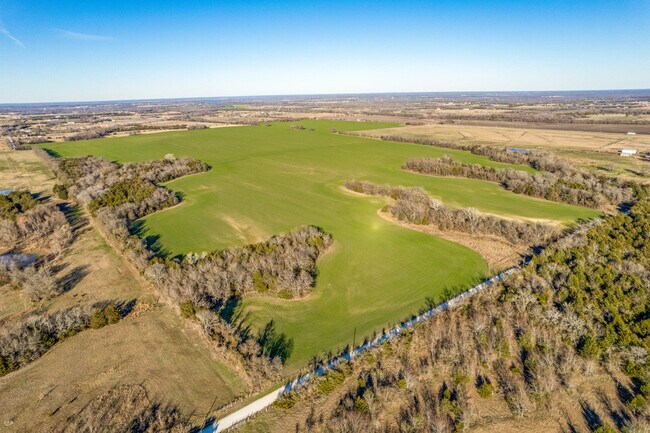
Agriculturalland
Texas
B and X Area of moderate flood hazard, usually the area between the limits of the 100-year and 500-year floods.
44.80 AC
2024
Texas North Area
2025
Other Market Areas
000101
NEARBY LISTINGS FOR SALE OR LEASE
-
-
View all Bells listings for sale on LoopNet.com
DEMOGRAPHICS near Us Highway 69
1 mile
3 mile
5 mile
2025 Total Population
34
1,628
7,051
2030 Population
37
1,764
7,524
Pop Growth 2025-2030
+ 8.82%
+ 8.35%
+ 6.71%
Average Age
43
41
40
2025 Total Households
13
619
2,688
HH Growth 2025-2030
+ 7.69%
+ 8.40%
+ 6.77%
Median Household Inc
$99,999
$76,027
$82,005
Avg Household Size
2.50
2.50
2.60
2025 Avg HH Vehicles
3.00
2.00
2.00
Median Home Value
$337,500
$313,576
$272,090
Median Year Built
1989
1983
1981
Nearby Places
Map Layers
Map Styles
 Street
 Aerial
Transit
 Traffic
 Biking
Places
Listings with unknown addresses are not visible on the map
- Restaurants
- Banks
- Shops
- Fitness
- Groceries
SALE & LEASE HISTORY
LISTING DATE
SALE/LEASE

Jan 09, 2025
For Sale
Nearby Properties
Address
Land Use
TOTAL SIZE
Lot Size
Zoning
Address
Land Use
TOTAL SIZE
Lot Size
Zoning
18,468 SF
1.79 AC
Address
Land Use
TOTAL SIZE
Lot Size
Zoning
189.18 AC
Address
Land Use
TOTAL SIZE
Lot Size
Zoning
8,577 SF
138.90 AC
Address
Land Use
TOTAL SIZE
Lot Size
Zoning
185.03 AC
Address
Land Use
TOTAL SIZE
Lot Size
Zoning
129 AC
Address
Land Use
TOTAL SIZE
Lot Size
Zoning
155 AC
Address
Land Use
TOTAL SIZE
Lot Size
Zoning
104.20 AC
Address
Land Use
TOTAL SIZE
Lot Size
Zoning
4,996 SF
30 AC
Address
Land Use
TOTAL SIZE
Lot Size
Zoning
8,802 SF
5 AC
Address
Land Use
TOTAL SIZE
Lot Size
Zoning
8,117 SF
22 AC
Address
Land Use
TOTAL SIZE
Lot Size
Zoning
115.50 AC
Address
Land Use
TOTAL SIZE
Lot Size
Zoning
2,880 SF
96.60 AC
Address
Land Use
TOTAL SIZE
Lot Size
Zoning
79.78 AC
Address
Land Use
TOTAL SIZE
Lot Size
Zoning
4,800 SF
96.60 AC
Address
Land Use
TOTAL SIZE
Lot Size
Zoning
240 SF
63.50 AC
Address
Land Use
TOTAL SIZE
Lot Size
Zoning
5,384 SF
31.82 AC
Address
Land Use
TOTAL SIZE
Lot Size
Zoning
80 AC
Address
Land Use
TOTAL SIZE
Lot Size
Zoning
2,432 SF
89.31 AC
Address
Land Use
TOTAL SIZE
Lot Size
Zoning
4,755 SF
35.69 AC
Address
Land Use
TOTAL SIZE
Lot Size
Zoning
9,520 SF
9.60 AC
Address
Land Use
TOTAL SIZE
Lot Size
Zoning
4,731 SF
1 AC
Address
Land Use
TOTAL SIZE
Lot Size
Zoning
10,234 SF
2.95 AC
Address
Land Use
TOTAL SIZE
Lot Size
Zoning
4,342 SF
13.46 AC
Address
Land Use
TOTAL SIZE
Lot Size
Zoning
8,344 SF
1 AC
Address
Land Use
TOTAL SIZE
Lot Size
Zoning
40.30 AC
Address
Land Use
TOTAL SIZE
Lot Size
Zoning
76.18 AC
Address
Land Use
TOTAL SIZE
Lot Size
Zoning
3,746 SF
19.72 AC
Address
Land Use
TOTAL SIZE
Lot Size
Zoning
4,177 SF
2.74 AC
Address
Land Use
TOTAL SIZE
Lot Size
Zoning
4,120 SF
24.62 AC
Address
Land Use
TOTAL SIZE
Lot Size
Zoning
3,958 SF
22.43 AC
The World's #1 Commercial Real Estate Marketplace
Connect with us
© 2026 CoStar Group
The information above has been obtained from sources believed reliable. While we do not doubt its accuracy we have not verified it and make no guarantee, warranty or representation about it. It is your responsibility to independently confirm its accuracy and completeness. Any projections, opinions, assumptions, or estimates used are for example only and do not represent the current or future performance of the property. The value of this transaction to you depends on tax and other factors which should be evaluated by your tax, financial, and legal advisors. You and your advisors should conduct a careful, independent investigation of the property to determine to your satisfaction the suitability of the property for your needs.