Property Record
Us Highway 72 S, Decatur, AL 35601
NEARBY LISTINGS FOR SALE OR LEASE
-
-
View all Decatur listings for lease on LoopNet.com
Property Detail
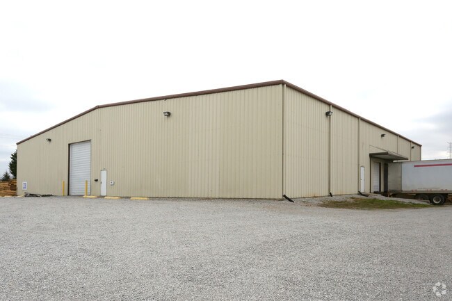
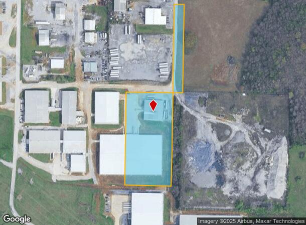
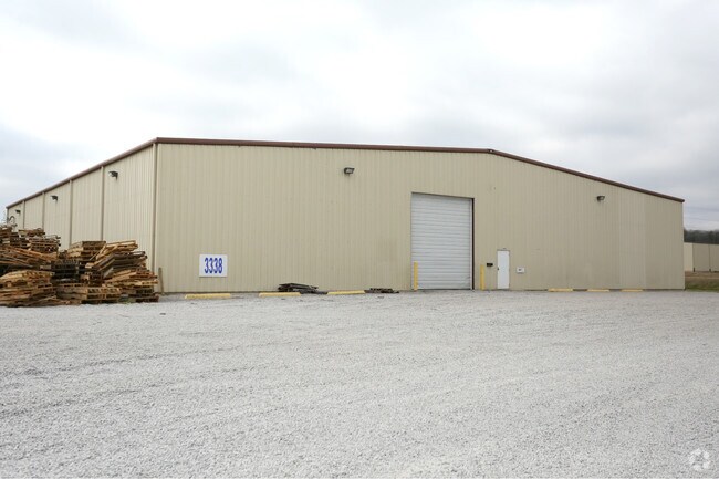
Us Highway 72 S
02-05-16-0-000-002.042
COM AT NE COR OF SEC 16 T5S, R5W, TH W 1764.77', TH SO 70.38' TO SO R/W OF HWY 20, TH W ALG SD R/W 862.14', TH SO 1179.25', T
Publicstorage
Morgan
X
Alabama
01103C0052F
4.90 AC
2025
Alabama North Area
2024
Other Market Areas
000700
Decatur, AL
15,120 SF
DEMOGRAPHICS near Us Highway 72 S
1 Mile
3 Mile
5 Mile
2024 Total Population
430
7,297
35,169
2029 Population
438
7,333
35,449
Pop Growth 2024-2029
+ 1.86%
+ 0.49%
+ 0.80%
Average Age
42
40
40
2024 Total Households
157
2,969
14,015
HH Growth 2024-2029
+ 1.91%
+ 0.44%
+ 0.81%
Median Household Inc
$115,972
$64,467
$50,078
Avg Household Size
2.70
2.40
2.40
2024 Avg HH Vehicles
3.00
2.00
2.00
Median Home Value
$220,000
$190,860
$152,654
Median Year Built
1991
1990
1978
Nearby Places
Map Layers
Map Styles
 Street
 Aerial
- Restaurants
- Banks
- Shops
- Fitness
- Groceries
PUBLIC TRANSPORTATION
AIRPORT
Huntsville International-Carl T Jones Field
DRIVE
WALK
Distance
Huntsville International-Carl T Jones Field
31 min
20.8 mi
Freight Ports
Port of Mobile
DRIVE
WALK
Distance
Port of Mobile
379 min
341.6 mi
SALE & LEASE HISTORY
LISTING DATE
SALE/LEASE

Feb 21, 2017
For Lease
Nearby Properties
Address
Land Use
TOTAL SIZE
Lot Size
Zoning
Address
Land Use
TOTAL SIZE
Lot Size
Zoning
65,550 SF
173 AC
Address
Land Use
TOTAL SIZE
Lot Size
Zoning
800 SF
296 AC
Address
Land Use
TOTAL SIZE
Lot Size
Zoning
176,476 SF
Address
Land Use
TOTAL SIZE
Lot Size
Zoning
70,936 SF
37 AC
Address
Land Use
TOTAL SIZE
Lot Size
Zoning
121,551 SF
Address
Land Use
TOTAL SIZE
Lot Size
Zoning
207 SF
90 AC
Address
Land Use
TOTAL SIZE
Lot Size
Zoning
12,612 SF
42 AC
Address
Land Use
TOTAL SIZE
Lot Size
Zoning
85,080 SF
21 AC
Address
Land Use
TOTAL SIZE
Lot Size
Zoning
49,762 SF
2.60 AC
Address
Land Use
TOTAL SIZE
Lot Size
Zoning
132,359 SF
Address
Land Use
TOTAL SIZE
Lot Size
Zoning
81,916 SF
45 AC
Address
Land Use
TOTAL SIZE
Lot Size
Zoning
124,209 SF
26 AC
Address
Land Use
TOTAL SIZE
Lot Size
Zoning
32,947 SF
567 AC
Address
Land Use
TOTAL SIZE
Lot Size
Zoning
90,249 SF
8 AC
Address
Land Use
TOTAL SIZE
Lot Size
Zoning
36,304 SF
97 AC
Address
Land Use
TOTAL SIZE
Lot Size
Zoning
15,331 SF
87 AC
Address
Land Use
TOTAL SIZE
Lot Size
Zoning
9,332 SF
Address
Land Use
TOTAL SIZE
Lot Size
Zoning
4.25 AC
Address
Land Use
TOTAL SIZE
Lot Size
Zoning
83,624 SF
28 AC
Address
Land Use
TOTAL SIZE
Lot Size
Zoning
154,000 SF
60 AC
Address
Land Use
TOTAL SIZE
Lot Size
Zoning
33,520 SF
Address
Land Use
TOTAL SIZE
Lot Size
Zoning
261,328 SF
67 AC
Address
Land Use
TOTAL SIZE
Lot Size
Zoning
85,080 SF
21 AC
Address
Land Use
TOTAL SIZE
Lot Size
Zoning
100,000 SF
1 AC
Address
Land Use
TOTAL SIZE
Lot Size
Zoning
62,709 SF
291 AC
Address
Land Use
TOTAL SIZE
Lot Size
Zoning
175,664 SF
13 AC
Address
Land Use
TOTAL SIZE
Lot Size
Zoning
3,466 SF
41 AC
Address
Land Use
TOTAL SIZE
Lot Size
Zoning
10,884 SF
0.90 AC
Address
Land Use
TOTAL SIZE
Lot Size
Zoning
40,008 SF
19.90 AC
Address
Land Use
TOTAL SIZE
Lot Size
Zoning
153,720 SF
30 AC
The World's #1 Commercial Real Estate Marketplace
Connect with us
© 2025 CoStar Group
The information above has been obtained from sources believed reliable. While we do not doubt its accuracy we have not verified it and make no guarantee, warranty or representation about it. It is your responsibility to independently confirm its accuracy and completeness. Any projections, opinions, assumptions, or estimates used are for example only and do not represent the current or future performance of the property. The value of this transaction to you depends on tax and other factors which should be evaluated by your tax, financial, and legal advisors. You and your advisors should conduct a careful, independent investigation of the property to determine to your satisfaction the suitability of the property for your needs.