Property Record
N Rbst Hwy, Robstown, TX 78380

This Property Is For Sale
Property Detail
N Rbst Hwy
Corpus Christi, TX
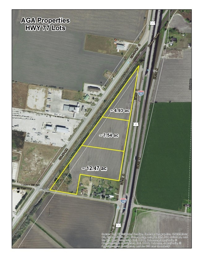
HERRERA GRANT S POR 7.545 ACS OUT TR 1-A
200097300
NUECES
Privatepreserveopenspacevacantlandforestlandconservation
Texas
INDUST
1-a
AE The base floodplain where base flood elevations are provided. AE Zones are now used on new format FIRMs instead of A1-A30 Zones.
7.55 AC
2024
Northwest
2025
Corpus Christi
005804
NEARBY LISTINGS FOR SALE OR LEASE
DEMOGRAPHICS near N Rbst Hwy
1 mile
3 mile
5 mile
2025 Total Population
228
15,329
40,847
2030 Population
230
15,457
40,649
Pop Growth 2025-2030
+ 0.88%
+ 0.84%
(0.48%)
Average Age
40
39
38
2025 Total Households
68
5,037
14,089
HH Growth 2025-2030
+ 1.47%
+ 0.68%
(0.77%)
Median Household Inc
$74,999
$57,648
$69,264
Avg Household Size
3.00
3.00
2.80
2025 Avg HH Vehicles
2.00
2.00
2.00
Median Home Value
$159,999
$139,285
$208,207
Median Year Built
1969
1974
1982
Nearby Places
Map Layers
Map Styles
 Street
 Aerial
Transit
 Traffic
 Biking
Places
Listings with unknown addresses are not visible on the map
- Restaurants
- Banks
- Shops
- Fitness
- Groceries
PUBLIC TRANSPORTATION
AIRPORT
Corpus Christi International
Drive
Walk
Distance
Corpus Christi International
17 min
12.5 mi
Freight Ports
Port of Corpus Christi
Drive
Walk
Distance
Port of Corpus Christi
25 min
19.8 mi
Nearby Properties
Address
Land Use
TOTAL SIZE
Lot Size
Zoning
Address
Land Use
TOTAL SIZE
Lot Size
Zoning
265,451 SF
54.68 AC
Address
Land Use
TOTAL SIZE
Lot Size
Zoning
71,004 SF
38.48 AC
Address
Land Use
TOTAL SIZE
Lot Size
Zoning
133,580 SF
50.28 AC
Address
Land Use
TOTAL SIZE
Lot Size
Zoning
177,230 SF
13.31 AC
Address
Land Use
TOTAL SIZE
Lot Size
Zoning
109,882 SF
10.31 AC
Address
Land Use
TOTAL SIZE
Lot Size
Zoning
50,207 SF
10.30 AC
Address
Land Use
TOTAL SIZE
Lot Size
Zoning
88,831 SF
14 AC
Address
Land Use
TOTAL SIZE
Lot Size
Zoning
73,740 SF
15 AC
Address
Land Use
TOTAL SIZE
Lot Size
Zoning
41,499 SF
2.33 AC
Address
Land Use
TOTAL SIZE
Lot Size
Zoning
207,487 SF
32.65 AC
Address
Land Use
TOTAL SIZE
Lot Size
Zoning
56,250 SF
4.74 AC
Address
Land Use
TOTAL SIZE
Lot Size
Zoning
85,908 SF
10.25 AC
Address
Land Use
TOTAL SIZE
Lot Size
Zoning
69,436 SF
10.82 AC
R1B
Address
Land Use
TOTAL SIZE
Lot Size
Zoning
81,002 SF
18.79 AC
I3
Address
Land Use
TOTAL SIZE
Lot Size
Zoning
61,440 SF
35.77 AC
I3
Address
Land Use
TOTAL SIZE
Lot Size
Zoning
356,824 SF
41.01 AC
Address
Land Use
TOTAL SIZE
Lot Size
Zoning
44,106 SF
10 AC
B4
Address
Land Use
TOTAL SIZE
Lot Size
Zoning
61,630 SF
33.70 AC
Address
Land Use
TOTAL SIZE
Lot Size
Zoning
38,379 SF
6.01 AC
Address
Land Use
TOTAL SIZE
Lot Size
Zoning
333.74 AC
OCL
Address
Land Use
TOTAL SIZE
Lot Size
Zoning
58,400 SF
14.64 AC
Address
Land Use
TOTAL SIZE
Lot Size
Zoning
297.80 AC
Address
Land Use
TOTAL SIZE
Lot Size
Zoning
30,985 SF
4.71 AC
B4
Address
Land Use
TOTAL SIZE
Lot Size
Zoning
40,401 SF
2.76 AC
B-4
Address
Land Use
TOTAL SIZE
Lot Size
Zoning
13,000 SF
5.93 AC
Address
Land Use
TOTAL SIZE
Lot Size
Zoning
43,814 SF
10.58 AC
Address
Land Use
TOTAL SIZE
Lot Size
Zoning
17,978 SF
9.26 AC
Address
Land Use
TOTAL SIZE
Lot Size
Zoning
14,885 SF
11.77 AC
Address
Land Use
TOTAL SIZE
Lot Size
Zoning
25,000 SF
48.93 AC
I3
Address
Land Use
TOTAL SIZE
Lot Size
Zoning
20,375 SF
9.12 AC
The World's #1 Commercial Real Estate Marketplace
Connect with us
© 2026 CoStar Group
The information above has been obtained from sources believed reliable. While we do not doubt its accuracy we have not verified it and make no guarantee, warranty or representation about it. It is your responsibility to independently confirm its accuracy and completeness. Any projections, opinions, assumptions, or estimates used are for example only and do not represent the current or future performance of the property. The value of this transaction to you depends on tax and other factors which should be evaluated by your tax, financial, and legal advisors. You and your advisors should conduct a careful, independent investigation of the property to determine to your satisfaction the suitability of the property for your needs.