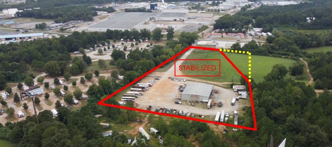
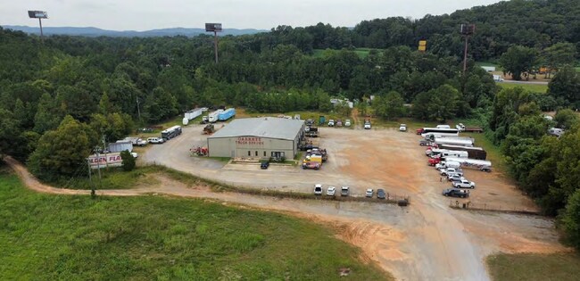
Property Record
Us Highway 78, Anniston, AL 36207
Property Detail
Us Highway 78
21-07-26-0-000-001.004
SEC 26 T16S R08E BEG 504.96 S OF NW COR NE 1/4 SEC 26 NE 500.33 S 423.42 SW 500.78 N 432.39 TO POB ANNISTON AL
Storebuilding
CALHOUN
AE The base floodplain where base flood elevations are provided. AE Zones are now used on new format FIRMs instead of A1-A30 Zones.
Alabama
2025
5.10 AC
2025
Gadsden/Anniston Area
000900
Other Market Areas
9,900 SF
Anniston-Oxford, AL
NEARBY LISTINGS FOR SALE OR LEASE
DEMOGRAPHICS near Us Highway 78
1 mile
3 mile
5 mile
2025 Total Population
675
12,409
29,322
2030 Population
672
12,199
29,274
Pop Growth 2025-2030
(0.44%)
(1.69%)
(0.16%)
Average Age
42
43
42
2025 Total Households
328
5,301
11,930
HH Growth 2025-2030
(0.61%)
(1.79%)
(0.32%)
Median Household Inc
$74,223
$72,705
$60,484
Avg Household Size
2.00
2.30
2.30
2025 Avg HH Vehicles
3.00
2.00
2.00
Median Home Value
$250,793
$225,761
$196,311
Median Year Built
1978
1983
1978
Nearby Places
Map Layers
Map Styles
 Street
 Aerial
Layers
 Traffic
 Biking
Places
Listings with unknown addresses are not visible on the map
- Restaurants
- Banks
- Shops
- Fitness
- Groceries
PUBLIC TRANSPORTATION
COMMUTER RAIL
Anniston Amtrak Station (Crescent - Amtrak)
Drive
Walk
Distance
Anniston Amtrak Station (Crescent - Amtrak)
10 min
5.9 mi
Freight Ports
Port of Panama City
Drive
Walk
Distance
Port of Panama City
362 min
292.9 mi
SALE & LEASE HISTORY
LISTING DATE
SALE/LEASE

Sep 09, 2024
For Lease
Sep 07, 2021
For Sale
Nearby Properties
Address
Land Use
TOTAL SIZE
Lot Size
Zoning
Address
Land Use
TOTAL SIZE
Lot Size
Zoning
45,466 SF
18 AC
Address
Land Use
TOTAL SIZE
Lot Size
Zoning
23,480 SF
14 AC
Address
Land Use
TOTAL SIZE
Lot Size
Zoning
5.32 AC
Address
Land Use
TOTAL SIZE
Lot Size
Zoning
126,689 SF
8.49 AC
Address
Land Use
TOTAL SIZE
Lot Size
Zoning
18.90 AC
Address
Land Use
TOTAL SIZE
Lot Size
Zoning
4,356 SF
60.40 AC
Address
Land Use
TOTAL SIZE
Lot Size
Zoning
1,335 SF
76 AC
Address
Land Use
TOTAL SIZE
Lot Size
Zoning
138,072 SF
11.60 AC
Address
Land Use
TOTAL SIZE
Lot Size
Zoning
341,374 SF
15.88 AC
Address
Land Use
TOTAL SIZE
Lot Size
Zoning
74,927 SF
2.47 AC
Address
Land Use
TOTAL SIZE
Lot Size
Zoning
346,532 SF
41 AC
Address
Land Use
TOTAL SIZE
Lot Size
Zoning
64,772 SF
2.56 AC
Address
Land Use
TOTAL SIZE
Lot Size
Zoning
160,000 SF
21 AC
Address
Land Use
TOTAL SIZE
Lot Size
Zoning
56,520 SF
2.51 AC
Address
Land Use
TOTAL SIZE
Lot Size
Zoning
4,366 SF
0.97 AC
Address
Land Use
TOTAL SIZE
Lot Size
Zoning
76,250 SF
14.60 AC
Address
Land Use
TOTAL SIZE
Lot Size
Zoning
4,030 SF
11.20 AC
Address
Land Use
TOTAL SIZE
Lot Size
Zoning
102,436 SF
12.52 AC
Address
Land Use
TOTAL SIZE
Lot Size
Zoning
534,926 SF
21.75 AC
Address
Land Use
TOTAL SIZE
Lot Size
Zoning
Address
Land Use
TOTAL SIZE
Lot Size
Zoning
54,232 SF
2.27 AC
Address
Land Use
TOTAL SIZE
Lot Size
Zoning
47,700 SF
Address
Land Use
TOTAL SIZE
Lot Size
Zoning
50,180 SF
7.60 AC
Address
Land Use
TOTAL SIZE
Lot Size
Zoning
135,128 SF
10.01 AC
Address
Land Use
TOTAL SIZE
Lot Size
Zoning
14,015 SF
8.50 AC
Address
Land Use
TOTAL SIZE
Lot Size
Zoning
86,508 SF
20 AC
Address
Land Use
TOTAL SIZE
Lot Size
Zoning
Address
Land Use
TOTAL SIZE
Lot Size
Zoning
31,104 SF
36 AC
Address
Land Use
TOTAL SIZE
Lot Size
Zoning
227,530 SF
24 AC
Address
Land Use
TOTAL SIZE
Lot Size
Zoning
4,118 SF
15.74 AC
The World's #1 Commercial Real Estate Marketplace
Connect with us
© 2026 CoStar Group
The information above has been obtained from sources believed reliable. While we do not doubt its accuracy we have not verified it and make no guarantee, warranty or representation about it. It is your responsibility to independently confirm its accuracy and completeness. Any projections, opinions, assumptions, or estimates used are for example only and do not represent the current or future performance of the property. The value of this transaction to you depends on tax and other factors which should be evaluated by your tax, financial, and legal advisors. You and your advisors should conduct a careful, independent investigation of the property to determine to your satisfaction the suitability of the property for your needs.