Property Record
Us Highway 92 W, Auburndale, FL 33823

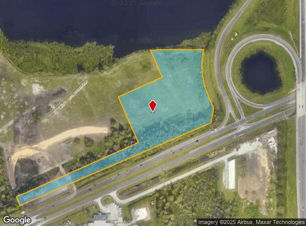
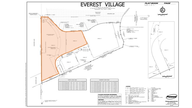
This Property Is For Sale
NEARBY LISTINGS FOR SALE OR LEASE
Property Detail
Us Highway 92 W
Tampa/St Petersburg
Orange Court
Lakeland-Winter Haven, FL
Polk
25-28-17-000000-031050
Florida
Residentialnec
7.99 AC
A
Polk County
12105C0340G
DEMOGRAPHICS near Us Highway 92 W
1 Mile
3 Mile
5 Mile
2024 Total Population
2,029
19,099
70,748
2029 Population
2,429
22,962
84,945
Pop Growth 2024-2029
+ 19.71%
+ 20.23%
+ 20.07%
Average Age
48
44
40
2024 Total Households
895
7,786
26,429
HH Growth 2024-2029
+ 19.78%
+ 20.32%
+ 20.06%
Median Household Inc
$48,059
$51,941
$50,575
Avg Household Size
2.20
2.40
2.60
2024 Avg HH Vehicles
1.00
2.00
2.00
Median Home Value
$69,552
$115,593
$153,629
Median Year Built
1991
1986
1982
Nearby Places
- Restaurants
- Banks
- Shops
- Fitness
- Groceries
PUBLIC TRANSPORTATION
COMMUTER RAIL
Lakeland (Silver Star - Amtrak)
DRIVE
WALK
Distance
Lakeland (Silver Star - Amtrak)
12 min
7.3 mi
Winter Haven (Silver Meteor - Amtrak, Silver Star - Amtrak)
DRIVE
WALK
Distance
Winter Haven (Silver Meteor - Amtrak, Silver Star - Amtrak)
16 min
9.2 mi
Freight Ports
Port of Tampa Bay
DRIVE
WALK
Distance
Port of Tampa Bay
57 min
41.4 mi
Nearby Properties
Address
Land Use
TOTAL SIZE
Lot Size
Zoning
Address
Land Use
TOTAL SIZE
Lot Size
Zoning
831,600 SF
51.22 AC
Address
Land Use
TOTAL SIZE
Lot Size
Zoning
811,392 SF
47.70 AC
Address
Land Use
TOTAL SIZE
Lot Size
Zoning
275,220 SF
94.53 AC
Address
Land Use
TOTAL SIZE
Lot Size
Zoning
238,721 SF
11.66 AC
GI
Address
Land Use
TOTAL SIZE
Lot Size
Zoning
202,567 SF
189.02 AC
RE1
Address
Land Use
TOTAL SIZE
Lot Size
Zoning
136,724 SF
4.62 AC
GI
Address
Land Use
TOTAL SIZE
Lot Size
Zoning
108,360 SF
4.23 AC
GI
Address
Land Use
TOTAL SIZE
Lot Size
Zoning
188,553 SF
29.12 AC
Address
Land Use
TOTAL SIZE
Lot Size
Zoning
178,899 SF
10.09 AC
GI
Address
Land Use
TOTAL SIZE
Lot Size
Zoning
84,129 SF
336.67 AC
Address
Land Use
TOTAL SIZE
Lot Size
Zoning
135,247 SF
22.49 AC
C4
Address
Land Use
TOTAL SIZE
Lot Size
Zoning
91,962 SF
19.46 AC
R4
Address
Land Use
TOTAL SIZE
Lot Size
Zoning
191,975 SF
14.28 AC
HI
Address
Land Use
TOTAL SIZE
Lot Size
Zoning
126,384 SF
4.67 AC
CH
Address
Land Use
TOTAL SIZE
Lot Size
Zoning
320,765 SF
14.93 AC
GI
Address
Land Use
TOTAL SIZE
Lot Size
Zoning
80,280 SF
25.05 AC
Address
Land Use
TOTAL SIZE
Lot Size
Zoning
80,100 SF
4.68 AC
GI
Address
Land Use
TOTAL SIZE
Lot Size
Zoning
77,279 SF
12.12 AC
Address
Land Use
TOTAL SIZE
Lot Size
Zoning
113,410 SF
19.78 AC
C4
Address
Land Use
TOTAL SIZE
Lot Size
Zoning
151,567 SF
6.34 AC
GI
Address
Land Use
TOTAL SIZE
Lot Size
Zoning
Address
Land Use
TOTAL SIZE
Lot Size
Zoning
23,800 SF
2.94 AC
Address
Land Use
TOTAL SIZE
Lot Size
Zoning
30,898 SF
7.27 AC
Address
Land Use
TOTAL SIZE
Lot Size
Zoning
54,204 SF
9.09 AC
Address
Land Use
TOTAL SIZE
Lot Size
Zoning
70,370 SF
4.86 AC
GI
Address
Land Use
TOTAL SIZE
Lot Size
Zoning
17,688 SF
3.16 AC
C3
Address
Land Use
TOTAL SIZE
Lot Size
Zoning
103,537 SF
15.63 AC
XX
Address
Land Use
TOTAL SIZE
Lot Size
Zoning
178,950 SF
23.99 AC
PUD
Address
Land Use
TOTAL SIZE
Lot Size
Zoning
35,397 SF
1.90 AC
Address
Land Use
TOTAL SIZE
Lot Size
Zoning
6,032 SF
2.26 AC
The World's #1 Commercial Real Estate Marketplace
Connect with us
© 2025 CoStar Group
The information above has been obtained from sources believed reliable. While we do not doubt its accuracy we have not verified it and make no guarantee, warranty or representation about it. It is your responsibility to independently confirm its accuracy and completeness. Any projections, opinions, assumptions, or estimates used are for example only and do not represent the current or future performance of the property. The value of this transaction to you depends on tax and other factors which should be evaluated by your tax, financial, and legal advisors. You and your advisors should conduct a careful, independent investigation of the property to determine to your satisfaction the suitability of the property for your needs.