Property Record
Us Highway 98 N, Lakeland, FL 33810


NEARBY LISTINGS FOR SALE OR LEASE
Property Detail
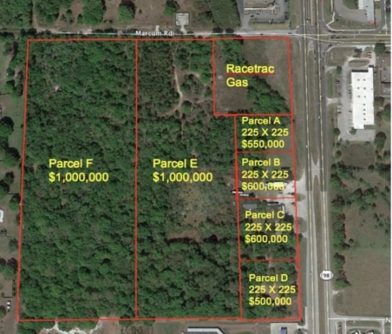
Us Highway 98 N
Lakeland-Winter Haven, FL
Cataloma Acres
23-27-23-000000-011020
NE1/4 OF NE1/4 LESS N1/2 OF SE1/4 OF NE1/4 OF NE1/4 LESS N 25 FT FOR RD & LESS ADD R/W FOR US 98 & LESS: COM NE COR OF SEC N89-46-22W 79.59 FT S00- 14-55E 25.00 FT TO INT OF S R/W LINE OF MARCUM RD & W R/W LINE OF US HWY 98 FOR POB S00-14-55E ALG W R
Commercialacreage
Polk
X
Florida
12105C0163G
29.81 AC
2024
Polk County
2025
Tampa/St Petersburg
012113
DEMOGRAPHICS near Us Highway 98 N
1 Mile
3 Mile
5 Mile
2024 Total Population
5,168
59,318
103,927
2029 Population
6,143
70,599
124,031
Pop Growth 2024-2029
+ 18.87%
+ 19.02%
+ 19.34%
Average Age
39
42
41
2024 Total Households
1,884
23,422
39,744
HH Growth 2024-2029
+ 18.68%
+ 18.96%
+ 19.28%
Median Household Inc
$58,076
$61,838
$58,015
Avg Household Size
2.70
2.50
2.50
2024 Avg HH Vehicles
2.00
2.00
2.00
Median Home Value
$211,442
$222,907
$208,647
Median Year Built
1990
1993
1992
Nearby Places
Map Layers
Map Styles
 Street
 Aerial
- Restaurants
- Banks
- Shops
- Fitness
- Groceries
PUBLIC TRANSPORTATION
COMMUTER RAIL
DRIVE
WALK
Distance
12 min
6.4 mi
AIRPORT
Tampa International
DRIVE
WALK
Distance
Tampa International
55 min
42.5 mi
Freight Ports
Port of Tampa Bay
DRIVE
WALK
Distance
Port of Tampa Bay
48 min
36.8 mi
Nearby Properties
Address
Land Use
TOTAL SIZE
Lot Size
Zoning
Address
Land Use
TOTAL SIZE
Lot Size
Zoning
493,501 SF
39.01 AC
MF12
Address
Land Use
TOTAL SIZE
Lot Size
Zoning
470,032 SF
23.21 AC
Address
Land Use
TOTAL SIZE
Lot Size
Zoning
1,091,160 SF
133.41 AC
PUD
Address
Land Use
TOTAL SIZE
Lot Size
Zoning
363,693 SF
22.54 AC
R2
Address
Land Use
TOTAL SIZE
Lot Size
Zoning
361,669 SF
12.73 AC
Address
Land Use
TOTAL SIZE
Lot Size
Zoning
246,838 SF
24.57 AC
PUD
Address
Land Use
TOTAL SIZE
Lot Size
Zoning
762,259 SF
24.95 AC
PUD
Address
Land Use
TOTAL SIZE
Lot Size
Zoning
208,898 SF
17.62 AC
PUD
Address
Land Use
TOTAL SIZE
Lot Size
Zoning
324,191 SF
23.37 AC
PUD
Address
Land Use
TOTAL SIZE
Lot Size
Zoning
169,546 SF
14.40 AC
PUD
Address
Land Use
TOTAL SIZE
Lot Size
Zoning
226,953 SF
34.42 AC
Address
Land Use
TOTAL SIZE
Lot Size
Zoning
425,986 SF
45.72 AC
C5
Address
Land Use
TOTAL SIZE
Lot Size
Zoning
171,525 SF
40.58 AC
RC
Address
Land Use
TOTAL SIZE
Lot Size
Zoning
115,608 SF
11.44 AC
RC
Address
Land Use
TOTAL SIZE
Lot Size
Zoning
142,936 SF
26.38 AC
Address
Land Use
TOTAL SIZE
Lot Size
Zoning
156,987 SF
51.52 AC
Address
Land Use
TOTAL SIZE
Lot Size
Zoning
101,501 SF
16.54 AC
Address
Land Use
TOTAL SIZE
Lot Size
Zoning
226,634 SF
27.21 AC
C3
Address
Land Use
TOTAL SIZE
Lot Size
Zoning
183,800 SF
19.26 AC
Address
Land Use
TOTAL SIZE
Lot Size
Zoning
206,724 SF
66.04 AC
RC
Address
Land Use
TOTAL SIZE
Lot Size
Zoning
118,250 SF
23.12 AC
Address
Land Use
TOTAL SIZE
Lot Size
Zoning
152,004 SF
15.81 AC
PUD
Address
Land Use
TOTAL SIZE
Lot Size
Zoning
149,871 SF
7.45 AC
PUD
Address
Land Use
TOTAL SIZE
Lot Size
Zoning
97,055 SF
7.21 AC
R4
Address
Land Use
TOTAL SIZE
Lot Size
Zoning
76,912 SF
7.09 AC
PUD
Address
Land Use
TOTAL SIZE
Lot Size
Zoning
96,768 SF
13.49 AC
C4
Address
Land Use
TOTAL SIZE
Lot Size
Zoning
121,595 SF
11.92 AC
Address
Land Use
TOTAL SIZE
Lot Size
Zoning
64,563 SF
5.48 AC
Address
Land Use
TOTAL SIZE
Lot Size
Zoning
75,493 SF
8.91 AC
Address
Land Use
TOTAL SIZE
Lot Size
Zoning
78,305 SF
5.23 AC
The World's #1 Commercial Real Estate Marketplace
Connect with us
© 2026 CoStar Group
The information above has been obtained from sources believed reliable. While we do not doubt its accuracy we have not verified it and make no guarantee, warranty or representation about it. It is your responsibility to independently confirm its accuracy and completeness. Any projections, opinions, assumptions, or estimates used are for example only and do not represent the current or future performance of the property. The value of this transaction to you depends on tax and other factors which should be evaluated by your tax, financial, and legal advisors. You and your advisors should conduct a careful, independent investigation of the property to determine to your satisfaction the suitability of the property for your needs.