Property Record
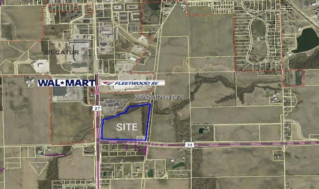
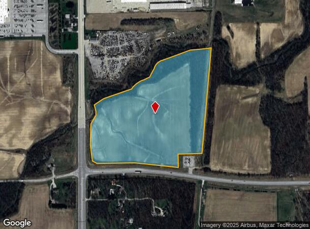
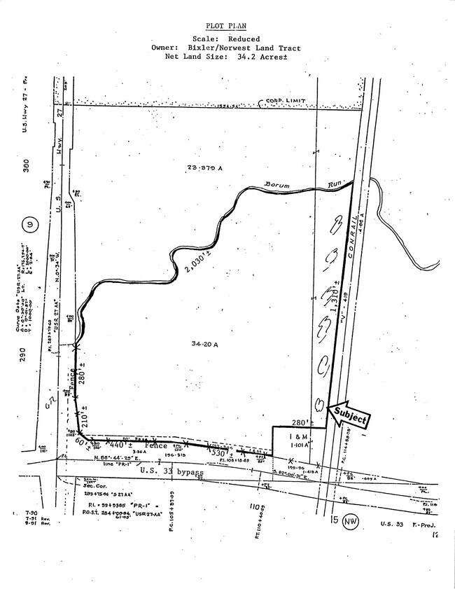
N Us Highway 27 At E Us Highway 33 Byp, Decatur, IN 46733

This Property Is For Sale
NEARBY LISTINGS FOR SALE OR LEASE
-
-
View all Decatur listings for sale on LoopNet.com
Property Detail
N Us Highway 27 At E Us Highway 33 Byp
01-05-10-300-002.000-021
S PT SW W OF RR & S OF RUN SEC 10 (34.20A)
Agriculturalland
Adams
A
Indiana
18001C0116E
34.20 AC
2024
Fort Wayne
2024
Other Market Areas
030200
Decatur, IN
DEMOGRAPHICS near N Us Highway 27 At E Us Highway 33 Byp
1 Mile
3 Mile
5 Mile
2024 Total Population
1,334
11,669
16,670
2029 Population
1,365
11,989
17,090
Pop Growth 2024-2029
+ 2.32%
+ 2.74%
+ 2.52%
Average Age
40
41
40
2024 Total Households
550
4,810
6,603
HH Growth 2024-2029
+ 2.18%
+ 2.62%
+ 2.41%
Median Household Inc
$36,842
$48,686
$53,107
Avg Household Size
2.30
2.30
2.40
2024 Avg HH Vehicles
2.00
2.00
2.00
Median Home Value
$140,058
$129,141
$147,229
Median Year Built
1979
1966
1968
Nearby Places
- Restaurants
- Banks
- Shops
- Fitness
- Groceries
PUBLIC TRANSPORTATION
AIRPORT
Fort Wayne International
DRIVE
WALK
Distance
Fort Wayne International
42 min
25.8 mi
Freight Ports
Port of Toledo
DRIVE
WALK
Distance
Port of Toledo
153 min
114.9 mi
Nearby Properties
Address
Land Use
TOTAL SIZE
Lot Size
Zoning
Address
Land Use
TOTAL SIZE
Lot Size
Zoning
562,416 SF
41.95 AC
I2
Address
Land Use
TOTAL SIZE
Lot Size
Zoning
184,013 SF
24.19 AC
R1
Address
Land Use
TOTAL SIZE
Lot Size
Zoning
1,792 SF
51.96 AC
Address
Land Use
TOTAL SIZE
Lot Size
Zoning
9,960 SF
11.01 AC
C2
Address
Land Use
TOTAL SIZE
Lot Size
Zoning
202,677 SF
39.93 AC
I1
Address
Land Use
TOTAL SIZE
Lot Size
Zoning
99,971 SF
24.32 AC
Address
Land Use
TOTAL SIZE
Lot Size
Zoning
107,341 SF
9.79 AC
Address
Land Use
TOTAL SIZE
Lot Size
Zoning
13,308 SF
19.84 AC
Address
Land Use
TOTAL SIZE
Lot Size
Zoning
62,458 SF
20.05 AC
Address
Land Use
TOTAL SIZE
Lot Size
Zoning
186,674 SF
17.53 AC
I2
Address
Land Use
TOTAL SIZE
Lot Size
Zoning
27,444 SF
1.20 AC
Address
Land Use
TOTAL SIZE
Lot Size
Zoning
152,564 SF
21.25 AC
I2
Address
Land Use
TOTAL SIZE
Lot Size
Zoning
128,675 SF
10.60 AC
I2
Address
Land Use
TOTAL SIZE
Lot Size
Zoning
43,308 SF
0.19 AC
Address
Land Use
TOTAL SIZE
Lot Size
Zoning
56,997 SF
5 AC
Address
Land Use
TOTAL SIZE
Lot Size
Zoning
1,032 SF
6.41 AC
R1
Address
Land Use
TOTAL SIZE
Lot Size
Zoning
31,216 SF
4.34 AC
Address
Land Use
TOTAL SIZE
Lot Size
Zoning
76,542 SF
25.26 AC
I1
Address
Land Use
TOTAL SIZE
Lot Size
Zoning
20,394 SF
10 AC
R1
Address
Land Use
TOTAL SIZE
Lot Size
Zoning
45,328 SF
10.03 AC
Address
Land Use
TOTAL SIZE
Lot Size
Zoning
6,528 SF
2.87 AC
Address
Land Use
TOTAL SIZE
Lot Size
Zoning
43,169 SF
0.20 AC
Address
Land Use
TOTAL SIZE
Lot Size
Zoning
216 SF
12 AC
Address
Land Use
TOTAL SIZE
Lot Size
Zoning
28,132 SF
2 AC
C2
Address
Land Use
TOTAL SIZE
Lot Size
Zoning
6,000 SF
7.70 AC
Address
Land Use
TOTAL SIZE
Lot Size
Zoning
34,992 SF
13.27 AC
Address
Land Use
TOTAL SIZE
Lot Size
Zoning
100,595 SF
22.43 AC
Address
Land Use
TOTAL SIZE
Lot Size
Zoning
14,200 SF
0.25 AC
Address
Land Use
TOTAL SIZE
Lot Size
Zoning
14,736 SF
0.86 AC
Address
Land Use
TOTAL SIZE
Lot Size
Zoning
0.90 AC
The World's #1 Commercial Real Estate Marketplace
Connect with us
© 2025 CoStar Group
The information above has been obtained from sources believed reliable. While we do not doubt its accuracy we have not verified it and make no guarantee, warranty or representation about it. It is your responsibility to independently confirm its accuracy and completeness. Any projections, opinions, assumptions, or estimates used are for example only and do not represent the current or future performance of the property. The value of this transaction to you depends on tax and other factors which should be evaluated by your tax, financial, and legal advisors. You and your advisors should conduct a careful, independent investigation of the property to determine to your satisfaction the suitability of the property for your needs.