Property Record
I85 S I85 S, Pike Road, AL 36064
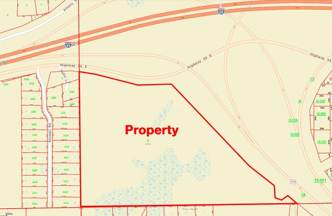
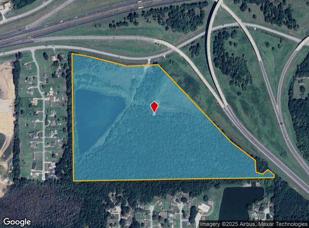
This Property Is For Sale
NEARBY LISTINGS FOR SALE OR LEASE
Property Detail
I85 S I85 S
08-04-17-3-000-003.000
SEC 17 T16N R20E 64.2 AC IN SW1/4 0804173000003000
Commercialacreage
Montgomery
AE
Alabama
01101C0252J
64.20 AC
2025
Outlying Montgomery Cnty
2025
Montgomery
005604
Montgomery, AL
DEMOGRAPHICS near I85 S I85 S
1 Mile
3 Mile
5 Mile
2024 Total Population
2,172
11,045
16,977
2029 Population
2,166
11,083
16,994
Pop Growth 2024-2029
(0.28%)
+ 0.34%
+ 0.10%
Average Age
35
37
38
2024 Total Households
767
3,454
5,589
HH Growth 2024-2029
(0.26%)
+ 0.41%
+ 0.11%
Median Household Inc
$102,657
$116,231
$110,694
Avg Household Size
2.80
2.80
2.70
2024 Avg HH Vehicles
2.00
2.00
2.00
Median Home Value
$369,298
$347,544
$346,932
Median Year Built
2010
2010
2008
Nearby Places
- Restaurants
- Banks
- Shops
- Fitness
- Groceries
PUBLIC TRANSPORTATION
AIRPORT
Montgomery Regional (Dannelly Field)
DRIVE
WALK
Distance
Montgomery Regional (Dannelly Field)
28 min
22.2 mi
Freight Ports
Port of Panama City
DRIVE
WALK
Distance
Port of Panama City
239 min
189.1 mi
Nearby Properties
Address
Land Use
TOTAL SIZE
Lot Size
Zoning
Address
Land Use
TOTAL SIZE
Lot Size
Zoning
25,762 SF
35.04 AC
PUD
Address
Land Use
TOTAL SIZE
Lot Size
Zoning
208,799 SF
17.34 AC
O-2
Address
Land Use
TOTAL SIZE
Lot Size
Zoning
160,604 SF
35.85 AC
B-2
Address
Land Use
TOTAL SIZE
Lot Size
Zoning
344,095 SF
30.02 AC
Address
Land Use
TOTAL SIZE
Lot Size
Zoning
170,644 SF
12.34 AC
Address
Land Use
TOTAL SIZE
Lot Size
Zoning
56,956 SF
10.37 AC
B-2
Address
Land Use
TOTAL SIZE
Lot Size
Zoning
52,600 SF
11.63 AC
Address
Land Use
TOTAL SIZE
Lot Size
Zoning
9,792 SF
160 AC
Address
Land Use
TOTAL SIZE
Lot Size
Zoning
117,633 SF
52.48 AC
Address
Land Use
TOTAL SIZE
Lot Size
Zoning
228,855 SF
15.70 AC
M-1
Address
Land Use
TOTAL SIZE
Lot Size
Zoning
96,764 SF
13.64 AC
M-1
Address
Land Use
TOTAL SIZE
Lot Size
Zoning
168,209 SF
21.62 AC
Address
Land Use
TOTAL SIZE
Lot Size
Zoning
168,209 SF
21.62 AC
Address
Land Use
TOTAL SIZE
Lot Size
Zoning
115,292 SF
49.50 AC
M-1
Address
Land Use
TOTAL SIZE
Lot Size
Zoning
113,724 SF
12.84 AC
B-2
Address
Land Use
TOTAL SIZE
Lot Size
Zoning
123,376 SF
23 AC
Address
Land Use
TOTAL SIZE
Lot Size
Zoning
9,806 SF
119.29 AC
Address
Land Use
TOTAL SIZE
Lot Size
Zoning
11,100 SF
10.50 AC
Address
Land Use
TOTAL SIZE
Lot Size
Zoning
139,221 SF
11.77 AC
M-1
Address
Land Use
TOTAL SIZE
Lot Size
Zoning
9,615 SF
4.16 AC
Address
Land Use
TOTAL SIZE
Lot Size
Zoning
49,843 SF
11.99 AC
M-1
Address
Land Use
TOTAL SIZE
Lot Size
Zoning
52,059 SF
4.10 AC
O-2
Address
Land Use
TOTAL SIZE
Lot Size
Zoning
14,596 SF
4.55 AC
PUD
Address
Land Use
TOTAL SIZE
Lot Size
Zoning
92,065 SF
46 AC
Address
Land Use
TOTAL SIZE
Lot Size
Zoning
5,000 SF
114.60 AC
Address
Land Use
TOTAL SIZE
Lot Size
Zoning
27,600 SF
7.55 AC
O-2
Address
Land Use
TOTAL SIZE
Lot Size
Zoning
1,192 SF
5 AC
M-1
Address
Land Use
TOTAL SIZE
Lot Size
Zoning
33,870 SF
5.10 AC
Address
Land Use
TOTAL SIZE
Lot Size
Zoning
43,260 SF
6.27 AC
M-1
Address
Land Use
TOTAL SIZE
Lot Size
Zoning
102,941 SF
6.68 AC
M-1
The World's #1 Commercial Real Estate Marketplace
Connect with us
© 2025 CoStar Group
The information above has been obtained from sources believed reliable. While we do not doubt its accuracy we have not verified it and make no guarantee, warranty or representation about it. It is your responsibility to independently confirm its accuracy and completeness. Any projections, opinions, assumptions, or estimates used are for example only and do not represent the current or future performance of the property. The value of this transaction to you depends on tax and other factors which should be evaluated by your tax, financial, and legal advisors. You and your advisors should conduct a careful, independent investigation of the property to determine to your satisfaction the suitability of the property for your needs.