Property Record
Us Rt 19, Shinnston, WV 26431


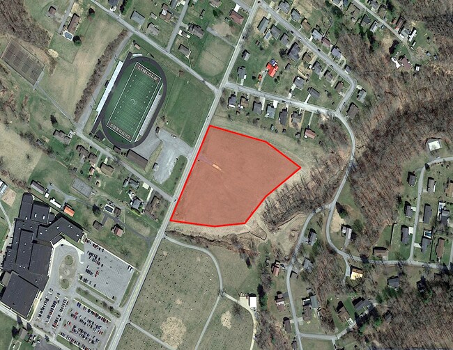
This Property Is For Sale
Property Detail
Us Rt 19
Clarksburg, WV
11.19 AC NR SHINNSTON
06-1008-01970000
HARRISON
Commercialacreage
West Virginia
B and X Area of moderate flood hazard, usually the area between the limits of the 100-year and 500-year floods.
11.19 AC
2025
West Virginia North Area
2025
Other Market Areas
031900
NEARBY LISTINGS FOR SALE OR LEASE
-
-
View all Shinnston listings for sale on LoopNet.com
DEMOGRAPHICS near Us Rt 19
1 mile
3 mile
5 mile
2025 Total Population
1,477
5,253
9,545
2030 Population
1,482
5,115
9,263
Pop Growth 2025-2030
+ 0.34%
(2.63%)
(2.95%)
Average Age
44
43
43
2025 Total Households
645
2,194
3,936
HH Growth 2025-2030
+ 0.31%
(2.69%)
(3.02%)
Median Household Inc
$64,363
$60,337
$61,698
Avg Household Size
2.30
2.30
2.40
2025 Avg HH Vehicles
2.00
2.00
2.00
Median Home Value
$197,158
$172,719
$170,736
Median Year Built
1964
1959
1961
Nearby Places
Map Layers
Map Styles
 Street
 Aerial
Layers
 Traffic
 Biking
Places
Listings with unknown addresses are not visible on the map
- Restaurants
- Banks
- Shops
- Fitness
- Groceries
PUBLIC TRANSPORTATION
AIRPORT
North Central West Virginia
Drive
Walk
Distance
North Central West Virginia
19 min
10.7 mi
Freight Ports
Port of Baltimore
Drive
Walk
Distance
Port of Baltimore
279 min
245.6 mi
Nearby Properties
Address
Land Use
TOTAL SIZE
Lot Size
Zoning
Address
Land Use
TOTAL SIZE
Lot Size
Zoning
1,085.26 AC
Address
Land Use
TOTAL SIZE
Lot Size
Zoning
240.18 AC
Address
Land Use
TOTAL SIZE
Lot Size
Zoning
1.04 AC
Address
Land Use
TOTAL SIZE
Lot Size
Zoning
21.48 AC
Address
Land Use
TOTAL SIZE
Lot Size
Zoning
1,680 SF
23.40 AC
Address
Land Use
TOTAL SIZE
Lot Size
Zoning
19.53 AC
Address
Land Use
TOTAL SIZE
Lot Size
Zoning
7.50 AC
Address
Land Use
TOTAL SIZE
Lot Size
Zoning
5.49 AC
Address
Land Use
TOTAL SIZE
Lot Size
Zoning
7.18 AC
Address
Land Use
TOTAL SIZE
Lot Size
Zoning
4.49 AC
Address
Land Use
TOTAL SIZE
Lot Size
Zoning
33.82 AC
Address
Land Use
TOTAL SIZE
Lot Size
Zoning
5.53 AC
Address
Land Use
TOTAL SIZE
Lot Size
Zoning
6,608 SF
1.08 AC
Address
Land Use
TOTAL SIZE
Lot Size
Zoning
Address
Land Use
TOTAL SIZE
Lot Size
Zoning
6.99 AC
Address
Land Use
TOTAL SIZE
Lot Size
Zoning
16.53 AC
Address
Land Use
TOTAL SIZE
Lot Size
Zoning
2.53 AC
Address
Land Use
TOTAL SIZE
Lot Size
Zoning
0.05 AC
Address
Land Use
TOTAL SIZE
Lot Size
Zoning
2.14 AC
Address
Land Use
TOTAL SIZE
Lot Size
Zoning
7.52 AC
Address
Land Use
TOTAL SIZE
Lot Size
Zoning
3.19 AC
Address
Land Use
TOTAL SIZE
Lot Size
Zoning
0.16 AC
Address
Land Use
TOTAL SIZE
Lot Size
Zoning
Address
Land Use
TOTAL SIZE
Lot Size
Zoning
0.30 AC
Address
Land Use
TOTAL SIZE
Lot Size
Zoning
3.64 AC
Address
Land Use
TOTAL SIZE
Lot Size
Zoning
6.50 AC
Address
Land Use
TOTAL SIZE
Lot Size
Zoning
9.66 AC
Address
Land Use
TOTAL SIZE
Lot Size
Zoning
2.16 AC
Address
Land Use
TOTAL SIZE
Lot Size
Zoning
0.17 AC
Address
Land Use
TOTAL SIZE
Lot Size
Zoning
1.50 AC
The World's #1 Commercial Real Estate Marketplace
Connect with us
© 2026 CoStar Group
The information above has been obtained from sources believed reliable. While we do not doubt its accuracy we have not verified it and make no guarantee, warranty or representation about it. It is your responsibility to independently confirm its accuracy and completeness. Any projections, opinions, assumptions, or estimates used are for example only and do not represent the current or future performance of the property. The value of this transaction to you depends on tax and other factors which should be evaluated by your tax, financial, and legal advisors. You and your advisors should conduct a careful, independent investigation of the property to determine to your satisfaction the suitability of the property for your needs.