Property Record
Vac Bartlett Rd, Smiths Creek, MI 48074

Property Detail
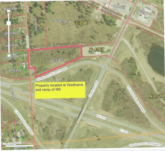
Vac Bartlett Rd
25-002-4018-001
BEG S 2D 10M 10S E 1334.96' FROM W 1/4 COR, TH S 2D 10M 10S E 251.33', TH N 87D 49M 50S E 87', TH S 2D 10M 10S E 113.65', TH N 70D 58M 42S E 705.38', TH N 1D 3M 55S W 145.59', TH S 88D 56M 5S W 765.04' TO BEG SECTION 2 T6N R16E 4.45 A SPLIT ON 11/03/
Commercialacreage
ST. CLAIR
C-2 COMM
Michigan
B and X Area of moderate flood hazard, usually the area between the limits of the 100-year and 500-year floods.
4.45 AC
2025
St Clair & Lapeer Counties
2025
Detroit
634100
Detroit-Warren-Dearborn, MI
NEARBY LISTINGS FOR SALE OR LEASE
-
-
View all Smiths Creek listings for sale on LoopNet.com
DEMOGRAPHICS near Vac Bartlett Rd
1 mile
3 mile
5 mile
2025 Total Population
1,172
12,196
34,890
2030 Population
1,180
12,131
34,664
Pop Growth 2025-2030
+ 0.68%
(0.53%)
(0.65%)
Average Age
45
43
42
2025 Total Households
499
4,830
13,495
HH Growth 2025-2030
+ 0.60%
(0.60%)
(0.78%)
Median Household Inc
$69,782
$72,650
$71,324
Avg Household Size
2.30
2.50
2.50
2025 Avg HH Vehicles
2.00
2.00
2.00
Median Home Value
$199,527
$224,060
$213,343
Median Year Built
1993
1977
1978
Nearby Places
Map Layers
Map Styles
 Street
 Aerial
Layers
 Traffic
 Biking
Places
Listings with unknown addresses are not visible on the map
- Restaurants
- Banks
- Shops
- Fitness
- Groceries
Nearby Properties
Address
Land Use
TOTAL SIZE
Lot Size
Zoning
Address
Land Use
TOTAL SIZE
Lot Size
Zoning
39,747 SF
3.11 AC
R-2 RES
Address
Land Use
TOTAL SIZE
Lot Size
Zoning
10,991 SF
119.58 AC
MIXED
Address
Land Use
TOTAL SIZE
Lot Size
Zoning
20,736 SF
10.20 AC
R-1
Address
Land Use
TOTAL SIZE
Lot Size
Zoning
5,359 SF
42.87 AC
R-4 RES
Address
Land Use
TOTAL SIZE
Lot Size
Zoning
7,785 SF
35.62 AC
C-2 COMM
Address
Land Use
TOTAL SIZE
Lot Size
Zoning
42,720 SF
6.21 AC
C-2 COMM
Address
Land Use
TOTAL SIZE
Lot Size
Zoning
25,756 SF
4.79 AC
R-1
Address
Land Use
TOTAL SIZE
Lot Size
Zoning
12,832 SF
116.08 AC
AG
Address
Land Use
TOTAL SIZE
Lot Size
Zoning
92,819 SF
31.18 AC
C-2 COMM
Address
Land Use
TOTAL SIZE
Lot Size
Zoning
76,760 SF
29 AC
C-2 COMM
Address
Land Use
TOTAL SIZE
Lot Size
Zoning
21,432 SF
6.69 AC
R-1
Address
Land Use
TOTAL SIZE
Lot Size
Zoning
3,387 SF
83.39 AC
AG
Address
Land Use
TOTAL SIZE
Lot Size
Zoning
27,719 SF
9.08 AC
MIXED
Address
Land Use
TOTAL SIZE
Lot Size
Zoning
23,519 SF
4.97 AC
C-2 COMM
Address
Land Use
TOTAL SIZE
Lot Size
Zoning
5,829 SF
65.90 AC
MHP
Address
Land Use
TOTAL SIZE
Lot Size
Zoning
18,540 SF
2 AC
R-1
Address
Land Use
TOTAL SIZE
Lot Size
Zoning
48,775 SF
7.01 AC
I-1 LIGHT
Address
Land Use
TOTAL SIZE
Lot Size
Zoning
11,987 SF
5 AC
R-1
Address
Land Use
TOTAL SIZE
Lot Size
Zoning
393 AC
AG
Address
Land Use
TOTAL SIZE
Lot Size
Zoning
40,927 SF
1.79 AC
C-2 COMM
Address
Land Use
TOTAL SIZE
Lot Size
Zoning
3.29 AC
C-2 COMM
Address
Land Use
TOTAL SIZE
Lot Size
Zoning
50 AC
MIXED
Address
Land Use
TOTAL SIZE
Lot Size
Zoning
3.07 AC
MIXED
Address
Land Use
TOTAL SIZE
Lot Size
Zoning
9,185 SF
4.31 AC
C-1 COMM
Address
Land Use
TOTAL SIZE
Lot Size
Zoning
12,544 SF
1.86 AC
R-1
Address
Land Use
TOTAL SIZE
Lot Size
Zoning
1,684 SF
15 AC
R-4 RES
Address
Land Use
TOTAL SIZE
Lot Size
Zoning
7,150 SF
2.41 AC
C-2 COMM
Address
Land Use
TOTAL SIZE
Lot Size
Zoning
3,317 SF
56.15 AC
AG
Address
Land Use
TOTAL SIZE
Lot Size
Zoning
8,849 SF
3.11 AC
R-1
Address
Land Use
TOTAL SIZE
Lot Size
Zoning
9,687 SF
1.27 AC
C-2 COMM
The World's #1 Commercial Real Estate Marketplace
Connect with us
© 2026 CoStar Group
The information above has been obtained from sources believed reliable. While we do not doubt its accuracy we have not verified it and make no guarantee, warranty or representation about it. It is your responsibility to independently confirm its accuracy and completeness. Any projections, opinions, assumptions, or estimates used are for example only and do not represent the current or future performance of the property. The value of this transaction to you depends on tax and other factors which should be evaluated by your tax, financial, and legal advisors. You and your advisors should conduct a careful, independent investigation of the property to determine to your satisfaction the suitability of the property for your needs.