Property Record
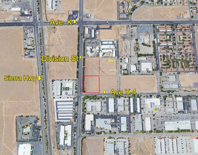
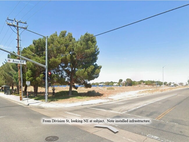
Vac Corner Division St Ave, Lancaster, CA 93535


NEARBY LISTINGS FOR SALE OR LEASE
Property Detail
Vac Corner Division St Ave
Los Angeles-Long Beach-Glendale, CA
32548
3126-031-058
TR=32548 LOT 11
Industrialacreage
Los Angeles
X
California
06037C0420F
11
2024
1.97 AC
2025
Antelope Valley
900508
Los Angeles
DEMOGRAPHICS near Vac Corner Division St Ave
1 Mile
3 Mile
5 Mile
2024 Total Population
13,434
99,354
161,665
2029 Population
13,217
96,393
156,886
Pop Growth 2024-2029
(1.62%)
(2.98%)
(2.96%)
Average Age
35
36
37
2024 Total Households
4,568
31,925
50,892
HH Growth 2024-2029
(1.80%)
(3.14%)
(3.15%)
Median Household Inc
$56,460
$52,319
$59,859
Avg Household Size
2.80
3.00
3.10
2024 Avg HH Vehicles
2.00
2.00
2.00
Median Home Value
$244,809
$263,538
$312,374
Median Year Built
1983
1981
1984
Nearby Places
Map Layers
Map Styles
 Street
 Aerial
- Restaurants
- Banks
- Shops
- Fitness
- Groceries
PUBLIC TRANSPORTATION
COMMUTER RAIL
Lancaster (Antelope Valley Line - Southern California Regional Rail Authority (Metrolink))
DRIVE
WALK
Distance
Lancaster (Antelope Valley Line - Southern California Regional Rail Authority (Metrolink))
3 min
2.0 mi
Palmdale (Antelope Valley Line - Southern California Regional Rail Authority (Metrolink))
DRIVE
WALK
Distance
Palmdale (Antelope Valley Line - Southern California Regional Rail Authority (Metrolink))
11 min
6.7 mi
Freight Ports
Port of Long Beach
DRIVE
WALK
Distance
Port of Long Beach
110 min
93.6 mi
SALE & LEASE HISTORY
LISTING DATE
SALE/LEASE

May 28, 2019
For Sale
Jun 15, 2023
For Sale
Aug 30, 2021
For Sale
Apr 19, 2023
For Sale
Nearby Properties
Address
Land Use
TOTAL SIZE
Lot Size
Zoning
Address
Land Use
TOTAL SIZE
Lot Size
Zoning
133,783 SF
48.02 AC
LRLI
Address
Land Use
TOTAL SIZE
Lot Size
Zoning
234,378 SF
15.25 AC
Address
Land Use
TOTAL SIZE
Lot Size
Zoning
143,852 SF
8.58 AC
LRHDR*
Address
Land Use
TOTAL SIZE
Lot Size
Zoning
153,117 SF
14.12 AC
LRSP80-01*
Address
Land Use
TOTAL SIZE
Lot Size
Zoning
160,028 SF
10.81 AC
LRMDR*
Address
Land Use
TOTAL SIZE
Lot Size
Zoning
179,304 SF
12.43 AC
LRMDR*
Address
Land Use
TOTAL SIZE
Lot Size
Zoning
126,102 SF
8.57 AC
LRRA7000*
Address
Land Use
TOTAL SIZE
Lot Size
Zoning
212,198 SF
18.27 AC
LRSP80-01*
Address
Land Use
TOTAL SIZE
Lot Size
Zoning
129,896 SF
9.10 AC
LRRPD70001
Address
Land Use
TOTAL SIZE
Lot Size
Zoning
74,213 SF
4.46 AC
LRA17000*
Address
Land Use
TOTAL SIZE
Lot Size
Zoning
185,527 SF
9.65 AC
LRR325U*
Address
Land Use
TOTAL SIZE
Lot Size
Zoning
81,668 SF
5.67 AC
LRRPD65002
Address
Land Use
TOTAL SIZE
Lot Size
Zoning
876,730 SF
20.85 AC
LRCP
Address
Land Use
TOTAL SIZE
Lot Size
Zoning
60,113 SF
2.03 AC
LRCPD
Address
Land Use
TOTAL SIZE
Lot Size
Zoning
123,924 SF
19.01 AC
LRA22*
Address
Land Use
TOTAL SIZE
Lot Size
Zoning
166,272 SF
8.71 AC
LRRA7000*
Address
Land Use
TOTAL SIZE
Lot Size
Zoning
132,584 SF
8.66 AC
LRMDR*
Address
Land Use
TOTAL SIZE
Lot Size
Zoning
170,697 SF
9.29 AC
LRRPD12U*
Address
Land Use
TOTAL SIZE
Lot Size
Zoning
90,429 SF
4.59 AC
LRHDR*
Address
Land Use
TOTAL SIZE
Lot Size
Zoning
90,429 SF
4.38 AC
LRHDR*
Address
Land Use
TOTAL SIZE
Lot Size
Zoning
214,178 SF
13.95 AC
LRRA7000*
Address
Land Use
TOTAL SIZE
Lot Size
Zoning
145,593 SF
5.18 AC
LRC3*
Address
Land Use
TOTAL SIZE
Lot Size
Zoning
76,093 SF
1.37 AC
LRC3*
Address
Land Use
TOTAL SIZE
Lot Size
Zoning
481,066 SF
11.88 AC
LRRA7500*
Address
Land Use
TOTAL SIZE
Lot Size
Zoning
97,566 SF
8.81 AC
LRC3*
Address
Land Use
TOTAL SIZE
Lot Size
Zoning
101,136 SF
4.18 AC
LRSP
Address
Land Use
TOTAL SIZE
Lot Size
Zoning
73,248 SF
3.56 AC
LRR325UDP*
Address
Land Use
TOTAL SIZE
Lot Size
Zoning
127,975 SF
4.77 AC
LRC3DP*
Address
Land Use
TOTAL SIZE
Lot Size
Zoning
183,296 SF
11.75 AC
LRRPD25U*
Address
Land Use
TOTAL SIZE
Lot Size
Zoning
81,606 SF
3.55 AC
LRSP80-02*
The World's #1 Commercial Real Estate Marketplace
Connect with us
© 2025 CoStar Group
The information above has been obtained from sources believed reliable. While we do not doubt its accuracy we have not verified it and make no guarantee, warranty or representation about it. It is your responsibility to independently confirm its accuracy and completeness. Any projections, opinions, assumptions, or estimates used are for example only and do not represent the current or future performance of the property. The value of this transaction to you depends on tax and other factors which should be evaluated by your tax, financial, and legal advisors. You and your advisors should conduct a careful, independent investigation of the property to determine to your satisfaction the suitability of the property for your needs.