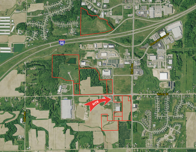
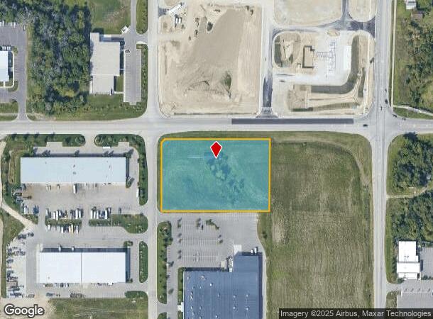
Property Record
3974 Central Pkwy, Hudsonville, MI 49426
NEARBY LISTINGS FOR SALE OR LEASE
-
-
View all Hudsonville listings for sale on LoopNet.com
Property Detail
3974 Central Pkwy
Grand Rapids-Wyoming, MI
Jamestown Commerce Center Sout
70-18-08-231-001
LOT 1 JAMESTOWN COMMERCE CENTER SOUTH NO 1
Industrialgeneral
Ottawa
X
Michigan
26005C0100G
1
2024
2.95 AC
2025
E Ottawa Cnty/Hudsonville
023001
West Michigan
DEMOGRAPHICS near 3974 Central Pkwy
1 Mile
3 Mile
5 Mile
2024 Total Population
3,256
17,385
55,006
2029 Population
3,442
18,309
57,747
Pop Growth 2024-2029
+ 5.71%
+ 5.31%
+ 4.98%
Average Age
34
36
38
2024 Total Households
1,072
6,022
18,825
HH Growth 2024-2029
+ 5.78%
+ 5.41%
+ 5.06%
Median Household Inc
$88,378
$88,718
$92,071
Avg Household Size
3.00
2.80
2.90
2024 Avg HH Vehicles
2.00
2.00
2.00
Median Home Value
$282,455
$273,802
$278,440
Median Year Built
2004
1998
1992
Nearby Places
- Restaurants
- Banks
- Shops
- Fitness
- Groceries
PUBLIC TRANSPORTATION
AIRPORT
Gerald R Ford International
DRIVE
WALK
Distance
Gerald R Ford International
29 min
20.8 mi
Freight Ports
Port Milwaukee
DRIVE
WALK
Distance
Port Milwaukee
290 min
249.1 mi
SALE & LEASE HISTORY
LISTING DATE
SALE/LEASE

Sep 24, 2016
For Sale
Jan 28, 2019
For Sale
Nearby Properties
Address
Land Use
TOTAL SIZE
Lot Size
Zoning
Address
Land Use
TOTAL SIZE
Lot Size
Zoning
196,665 SF
46.39 AC
SEE MAP
Address
Land Use
TOTAL SIZE
Lot Size
Zoning
273,515 SF
Address
Land Use
TOTAL SIZE
Lot Size
Zoning
20.61 AC
HDR
Address
Land Use
TOTAL SIZE
Lot Size
Zoning
114,312 SF
22.23 AC
R-4
Address
Land Use
TOTAL SIZE
Lot Size
Zoning
392,381 SF
21.73 AC
SEE MAP
Address
Land Use
TOTAL SIZE
Lot Size
Zoning
85,799 SF
12.89 AC
SEE MAP
Address
Land Use
TOTAL SIZE
Lot Size
Zoning
138,648 SF
Address
Land Use
TOTAL SIZE
Lot Size
Zoning
60,000 SF
18.36 AC
I-1
Address
Land Use
TOTAL SIZE
Lot Size
Zoning
74.03 AC
MHP
Address
Land Use
TOTAL SIZE
Lot Size
Zoning
83,640 SF
R-1-A
Address
Land Use
TOTAL SIZE
Lot Size
Zoning
Address
Land Use
TOTAL SIZE
Lot Size
Zoning
66,766 SF
R-1-A
Address
Land Use
TOTAL SIZE
Lot Size
Zoning
162,719 SF
19.77 AC
SEE MAP
Address
Land Use
TOTAL SIZE
Lot Size
Zoning
121,265 SF
17.97 AC
I-2
Address
Land Use
TOTAL SIZE
Lot Size
Zoning
8,464 SF
80.47 AC
SEE MAP
Address
Land Use
TOTAL SIZE
Lot Size
Zoning
56,784 SF
7.93 AC
R-4
Address
Land Use
TOTAL SIZE
Lot Size
Zoning
11.56 AC
SEE MAP
Address
Land Use
TOTAL SIZE
Lot Size
Zoning
6.29 AC
SEE MAP
Address
Land Use
TOTAL SIZE
Lot Size
Zoning
78,846 SF
8.73 AC
I
Address
Land Use
TOTAL SIZE
Lot Size
Zoning
8,448 SF
2.68 AC
R-4
Address
Land Use
TOTAL SIZE
Lot Size
Zoning
91,450 SF
10.45 AC
SEE MAP
Address
Land Use
TOTAL SIZE
Lot Size
Zoning
78,392 SF
10.45 AC
I-2
Address
Land Use
TOTAL SIZE
Lot Size
Zoning
0.50 AC
Address
Land Use
TOTAL SIZE
Lot Size
Zoning
38,017 SF
5.46 AC
HC
Address
Land Use
TOTAL SIZE
Lot Size
Zoning
103,976 SF
8.68 AC
IND-G
Address
Land Use
TOTAL SIZE
Lot Size
Zoning
50,578 SF
31.51 AC
SEE MAP
Address
Land Use
TOTAL SIZE
Lot Size
Zoning
32,400 SF
67.30 AC
SEE MAP
Address
Land Use
TOTAL SIZE
Lot Size
Zoning
28,526 SF
3.39 AC
HC
Address
Land Use
TOTAL SIZE
Lot Size
Zoning
42,914 SF
4.04 AC
SEE MAP
Address
Land Use
TOTAL SIZE
Lot Size
Zoning
28,912 SF
5.31 AC
I-2
The World's #1 Commercial Real Estate Marketplace
Connect with us
© 2025 CoStar Group
The information above has been obtained from sources believed reliable. While we do not doubt its accuracy we have not verified it and make no guarantee, warranty or representation about it. It is your responsibility to independently confirm its accuracy and completeness. Any projections, opinions, assumptions, or estimates used are for example only and do not represent the current or future performance of the property. The value of this transaction to you depends on tax and other factors which should be evaluated by your tax, financial, and legal advisors. You and your advisors should conduct a careful, independent investigation of the property to determine to your satisfaction the suitability of the property for your needs.