Property Record
La Honda Way, Yucca Valley, CA 92284


NEARBY LISTINGS FOR SALE OR LEASE
Property Detail
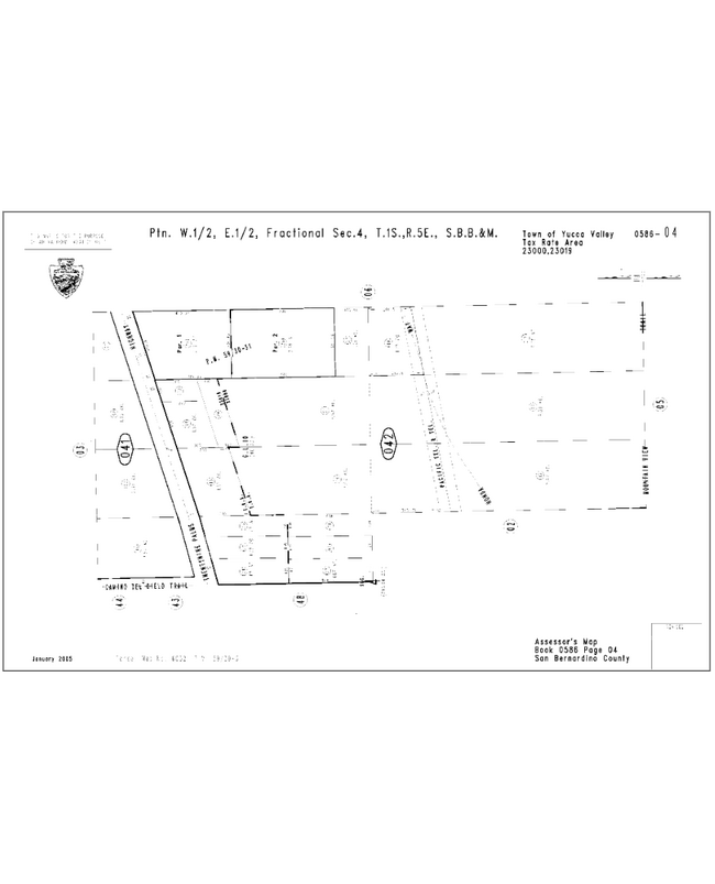
La Honda Way
0586-042-21
PTN W 1/2 E 1/2 W 1/2 E 1/2 SEC 4 TP 1S R 5E LYING S OF SLY LI 29 PALMS HGWY EX COM AT INTERSECTION E LI W 1/2 E 1/2 SW 1/4 NE 1/4 SD SEC AND SLY LI 29 PALMS HGWY TH SWLY ALG SD SLY LI HGWY TO W LI W 1/2 E 1/2 SW 1/4 NE 1/4 TH S 300 FT TH NELY PARALL
Vacantlandnec
San Bernardino
X
California
06065C0250G
7.52 AC
2024
Twentynine Palms
2025
Inland Empire (California)
010428
Riverside-San Bernardino-Ontario, CA
DEMOGRAPHICS near La Honda Way
1 Mile
3 Mile
5 Mile
2024 Total Population
2,908
12,548
22,602
2029 Population
3,010
12,943
23,294
Pop Growth 2024-2029
+ 3.51%
+ 3.15%
+ 3.06%
Average Age
45
43
43
2024 Total Households
1,348
5,396
9,319
HH Growth 2024-2029
+ 3.56%
+ 3.22%
+ 3.10%
Median Household Inc
$43,031
$53,204
$62,939
Avg Household Size
2.10
2.30
2.40
2024 Avg HH Vehicles
2.00
2.00
2.00
Median Home Value
$379,838
$271,521
$308,027
Median Year Built
1975
1977
1979
Nearby Places
Map Layers
Map Styles
 Street
 Aerial
- Restaurants
- Banks
- Shops
- Fitness
- Groceries
PUBLIC TRANSPORTATION
AIRPORT
Palm Springs International
DRIVE
WALK
Distance
Palm Springs International
37 min
28.5 mi
Freight Ports
Port of Long Beach
DRIVE
WALK
Distance
Port of Long Beach
149 min
120.4 mi
SALE & LEASE HISTORY
LISTING DATE
SALE/LEASE

Mar 17, 2019
For Sale
Nearby Properties
Address
Land Use
TOTAL SIZE
Lot Size
Zoning
Address
Land Use
TOTAL SIZE
Lot Size
Zoning
178,083 SF
1.75 AC
Address
Land Use
TOTAL SIZE
Lot Size
Zoning
51,455 SF
2.83 AC
Address
Land Use
TOTAL SIZE
Lot Size
Zoning
81,904 SF
2 AC
Address
Land Use
TOTAL SIZE
Lot Size
Zoning
45,139 SF
3.67 AC
Address
Land Use
TOTAL SIZE
Lot Size
Zoning
19,950 SF
1.57 AC
Address
Land Use
TOTAL SIZE
Lot Size
Zoning
25,193 SF
2.72 AC
Address
Land Use
TOTAL SIZE
Lot Size
Zoning
18,152 SF
5 AC
Address
Land Use
TOTAL SIZE
Lot Size
Zoning
18,124 SF
1.07 AC
Address
Land Use
TOTAL SIZE
Lot Size
Zoning
49,282 SF
2.74 AC
Address
Land Use
TOTAL SIZE
Lot Size
Zoning
43,920 SF
4.38 AC
Address
Land Use
TOTAL SIZE
Lot Size
Zoning
4,264 SF
0.60 AC
Address
Land Use
TOTAL SIZE
Lot Size
Zoning
13,000 SF
0.49 AC
Address
Land Use
TOTAL SIZE
Lot Size
Zoning
48,946 SF
2.01 AC
Address
Land Use
TOTAL SIZE
Lot Size
Zoning
25,600 SF
2 AC
Address
Land Use
TOTAL SIZE
Lot Size
Zoning
19,241 SF
19.30 AC
Address
Land Use
TOTAL SIZE
Lot Size
Zoning
8,556 SF
1.41 AC
Address
Land Use
TOTAL SIZE
Lot Size
Zoning
57,146 SF
4.33 AC
Address
Land Use
TOTAL SIZE
Lot Size
Zoning
20,038 SF
7.94 AC
Address
Land Use
TOTAL SIZE
Lot Size
Zoning
20,935 SF
1.59 AC
Address
Land Use
TOTAL SIZE
Lot Size
Zoning
32,909 SF
0.68 AC
Address
Land Use
TOTAL SIZE
Lot Size
Zoning
29,120 SF
2.95 AC
926
Address
Land Use
TOTAL SIZE
Lot Size
Zoning
7.03 AC
Address
Land Use
TOTAL SIZE
Lot Size
Zoning
10,008 SF
1 AC
926
Address
Land Use
TOTAL SIZE
Lot Size
Zoning
12,295 SF
1.23 AC
Address
Land Use
TOTAL SIZE
Lot Size
Zoning
12,766 SF
0.48 AC
Address
Land Use
TOTAL SIZE
Lot Size
Zoning
15,584 SF
1.25 AC
926
Address
Land Use
TOTAL SIZE
Lot Size
Zoning
27,002 SF
6.87 AC
Address
Land Use
TOTAL SIZE
Lot Size
Zoning
3,259 SF
0.65 AC
Address
Land Use
TOTAL SIZE
Lot Size
Zoning
52,703 SF
3.09 AC
Address
Land Use
TOTAL SIZE
Lot Size
Zoning
2,766 SF
0.69 AC
The World's #1 Commercial Real Estate Marketplace
Connect with us
© 2025 CoStar Group
The information above has been obtained from sources believed reliable. While we do not doubt its accuracy we have not verified it and make no guarantee, warranty or representation about it. It is your responsibility to independently confirm its accuracy and completeness. Any projections, opinions, assumptions, or estimates used are for example only and do not represent the current or future performance of the property. The value of this transaction to you depends on tax and other factors which should be evaluated by your tax, financial, and legal advisors. You and your advisors should conduct a careful, independent investigation of the property to determine to your satisfaction the suitability of the property for your needs.