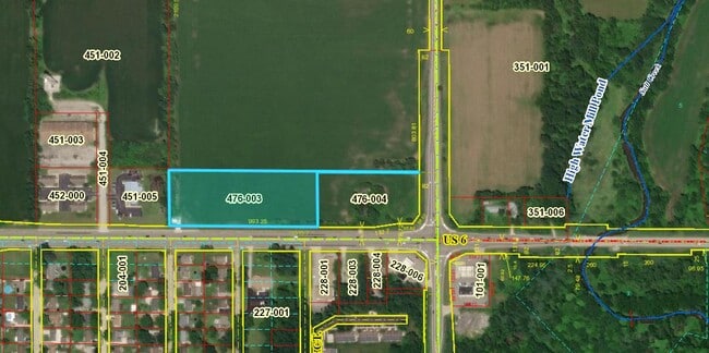
Property Record
Vacant Us Highway 6, Valparaiso, IN 46385
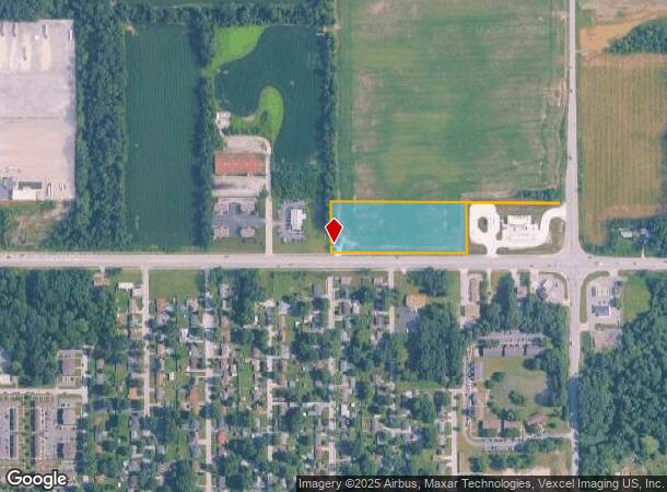
This Property Is For Sale
NEARBY LISTINGS FOR SALE OR LEASE
Property Detail
Vacant Us Highway 6
Chicago-Naperville-Elgin, IL-IN-WI
S10A E1/2 SE 20-36-6 EX PT IN S327.85 E587.12 & EX PT IN RD 4.58A
64-06-20-476-003.000-015
Porter
Agriculturalland
Indiana
2023
44 SF
2024
Porter County
050606
Chicago
DEMOGRAPHICS near Vacant Us Highway 6
1 Mile
3 Mile
5 Mile
2024 Total Population
4,499
27,719
79,950
2029 Population
4,479
28,151
81,761
Pop Growth 2024-2029
(0.44%)
+ 1.56%
+ 2.27%
Average Age
39
40
40
2024 Total Households
1,699
10,132
30,633
HH Growth 2024-2029
(0.47%)
+ 1.53%
+ 2.29%
Median Household Inc
$59,601
$75,888
$74,008
Avg Household Size
2.60
2.70
2.50
2024 Avg HH Vehicles
2.00
2.00
2.00
Median Home Value
$156,987
$209,564
$216,208
Median Year Built
1969
1984
1983
Nearby Places
- Restaurants
- Banks
- Shops
- Fitness
- Groceries
PUBLIC TRANSPORTATION
COMMUTER RAIL
Ogden Dunes (Portage) Station (South Shore Line - Northern Indiana Commuter Transportation District (South Shore Line))
DRIVE
WALK
Distance
Ogden Dunes (Portage) Station (South Shore Line - Northern Indiana Commuter Transportation District (South Shore Line))
12 min
8.1 mi
Dune Park (Chesterton) Station (South Shore Line - Northern Indiana Commuter Transportation District (South Shore Line))
DRIVE
WALK
Distance
Dune Park (Chesterton) Station (South Shore Line - Northern Indiana Commuter Transportation District (South Shore Line))
14 min
8.9 mi
Freight Ports
Port Milwaukee
DRIVE
WALK
Distance
Port Milwaukee
164 min
129.7 mi
Nearby Properties
Address
Land Use
TOTAL SIZE
Lot Size
Zoning
Address
Land Use
TOTAL SIZE
Lot Size
Zoning
218,452 SF
87 SF
Address
Land Use
TOTAL SIZE
Lot Size
Zoning
168,126 SF
44 SF
Address
Land Use
TOTAL SIZE
Lot Size
Zoning
169,427 SF
44 SF
Address
Land Use
TOTAL SIZE
Lot Size
Zoning
215,770 SF
87 SF
Address
Land Use
TOTAL SIZE
Lot Size
Zoning
133,249 SF
44 SF
Address
Land Use
TOTAL SIZE
Lot Size
Zoning
112,216 SF
44 SF
Address
Land Use
TOTAL SIZE
Lot Size
Zoning
140,434 SF
15.26 AC
Address
Land Use
TOTAL SIZE
Lot Size
Zoning
69,459 SF
13.97 AC
Address
Land Use
TOTAL SIZE
Lot Size
Zoning
223,221 SF
87 SF
Address
Land Use
TOTAL SIZE
Lot Size
Zoning
118,798 SF
44 SF
Address
Land Use
TOTAL SIZE
Lot Size
Zoning
50,382 SF
9.83 AC
Address
Land Use
TOTAL SIZE
Lot Size
Zoning
95,281 SF
44 SF
Address
Land Use
TOTAL SIZE
Lot Size
Zoning
191,547 SF
87 SF
Address
Land Use
TOTAL SIZE
Lot Size
Zoning
70,762 SF
3.04 AC
Address
Land Use
TOTAL SIZE
Lot Size
Zoning
70,454 SF
1.14 AC
Address
Land Use
TOTAL SIZE
Lot Size
Zoning
70,454 SF
1.20 AC
Address
Land Use
TOTAL SIZE
Lot Size
Zoning
56,308 SF
44 SF
Address
Land Use
TOTAL SIZE
Lot Size
Zoning
39,644 SF
2.84 AC
Address
Land Use
TOTAL SIZE
Lot Size
Zoning
89,232 SF
44 SF
Address
Land Use
TOTAL SIZE
Lot Size
Zoning
71,682 SF
4.40 AC
Address
Land Use
TOTAL SIZE
Lot Size
Zoning
108,527 SF
44 SF
Address
Land Use
TOTAL SIZE
Lot Size
Zoning
134,075 SF
44 SF
Address
Land Use
TOTAL SIZE
Lot Size
Zoning
15,644 SF
0.03 AC
Address
Land Use
TOTAL SIZE
Lot Size
Zoning
42,066 SF
13.06 AC
Address
Land Use
TOTAL SIZE
Lot Size
Zoning
34,050 SF
0.81 AC
Address
Land Use
TOTAL SIZE
Lot Size
Zoning
33,747 SF
0.69 AC
Address
Land Use
TOTAL SIZE
Lot Size
Zoning
33,747 SF
0.67 AC
Address
Land Use
TOTAL SIZE
Lot Size
Zoning
33,747 SF
0.59 AC
Address
Land Use
TOTAL SIZE
Lot Size
Zoning
48,153 SF
5.13 AC
Address
Land Use
TOTAL SIZE
Lot Size
Zoning
72,400 SF
2.82 AC
The World's #1 Commercial Real Estate Marketplace
Connect with us
© 2025 CoStar Group
The information above has been obtained from sources believed reliable. While we do not doubt its accuracy we have not verified it and make no guarantee, warranty or representation about it. It is your responsibility to independently confirm its accuracy and completeness. Any projections, opinions, assumptions, or estimates used are for example only and do not represent the current or future performance of the property. The value of this transaction to you depends on tax and other factors which should be evaluated by your tax, financial, and legal advisors. You and your advisors should conduct a careful, independent investigation of the property to determine to your satisfaction the suitability of the property for your needs.