Property Record
Valleybrook Dr, Lancaster, PA 17601

NEARBY LISTINGS FOR SALE OR LEASE
Property Detail
Valleybrook Dr
390-72479-0-0000
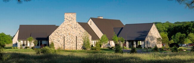
VALLEYBROOK DR
Commercialacreage
Lancaster
A
Pennsylvania
42071C0358F
15.14 AC
2024
Lancaster County
2025
Philadelphia
011806
Lancaster, PA
DEMOGRAPHICS near Valleybrook Dr
1 Mile
3 Mile
5 Mile
2024 Total Population
6,869
55,066
172,328
2029 Population
6,938
55,714
173,823
Pop Growth 2024-2029
+ 1.00%
+ 1.18%
+ 0.87%
Average Age
43
43
41
2024 Total Households
2,839
20,718
66,212
HH Growth 2024-2029
+ 1.06%
+ 1.25%
+ 0.84%
Median Household Inc
$88,144
$85,415
$75,750
Avg Household Size
2.20
2.50
2.40
2024 Avg HH Vehicles
2.00
2.00
2.00
Median Home Value
$293,177
$274,075
$254,393
Median Year Built
1975
1974
1969
Nearby Places
Map Layers
Map Styles
 Street
 Aerial
- Restaurants
- Banks
- Shops
- Fitness
- Groceries
PUBLIC TRANSPORTATION
COMMUTER RAIL
Lancaster (Keystone Service - Amtrak, Pennsylvanian - Amtrak)
DRIVE
WALK
Distance
Lancaster (Keystone Service - Amtrak, Pennsylvanian - Amtrak)
6 min
3.3 mi
AIRPORT
Harrisburg International
DRIVE
WALK
Distance
Harrisburg International
43 min
32.9 mi
Freight Ports
Port of Wilmington, RI
DRIVE
WALK
Distance
Port of Wilmington, RI
97 min
55.8 mi
Nearby Properties
Address
Land Use
TOTAL SIZE
Lot Size
Zoning
Address
Land Use
TOTAL SIZE
Lot Size
Zoning
1,070,497 SF
149.62 AC
Address
Land Use
TOTAL SIZE
Lot Size
Zoning
822,447 SF
77.29 AC
Address
Land Use
TOTAL SIZE
Lot Size
Zoning
871,695 SF
69.40 AC
R2
Address
Land Use
TOTAL SIZE
Lot Size
Zoning
740,990 SF
106.29 AC
Address
Land Use
TOTAL SIZE
Lot Size
Zoning
678,995 SF
96.17 AC
Address
Land Use
TOTAL SIZE
Lot Size
Zoning
259,035 SF
744.42 AC
Address
Land Use
TOTAL SIZE
Lot Size
Zoning
333,301 SF
24.15 AC
MU
Address
Land Use
TOTAL SIZE
Lot Size
Zoning
275,959 SF
68.50 AC
IN
Address
Land Use
TOTAL SIZE
Lot Size
Zoning
233,738 SF
34.10 AC
Address
Land Use
TOTAL SIZE
Lot Size
Zoning
354,921 SF
6.36 AC
Address
Land Use
TOTAL SIZE
Lot Size
Zoning
283,042 SF
17.50 AC
Address
Land Use
TOTAL SIZE
Lot Size
Zoning
203,415 SF
10.74 AC
Address
Land Use
TOTAL SIZE
Lot Size
Zoning
99,894 SF
21.88 AC
Address
Land Use
TOTAL SIZE
Lot Size
Zoning
254,079 SF
21.54 AC
Address
Land Use
TOTAL SIZE
Lot Size
Zoning
234,681 SF
7.50 AC
MU
Address
Land Use
TOTAL SIZE
Lot Size
Zoning
223,327 SF
21.80 AC
B-4
Address
Land Use
TOTAL SIZE
Lot Size
Zoning
203,942 SF
21.22 AC
B-4
Address
Land Use
TOTAL SIZE
Lot Size
Zoning
246,742 SF
12.49 AC
B-4
Address
Land Use
TOTAL SIZE
Lot Size
Zoning
131,294 SF
11.14 AC
B-4
Address
Land Use
TOTAL SIZE
Lot Size
Zoning
10 SF
14.11 AC
CM
Address
Land Use
TOTAL SIZE
Lot Size
Zoning
1,382,541 SF
106.20 AC
Address
Land Use
TOTAL SIZE
Lot Size
Zoning
18,843 SF
4.62 AC
I-2
Address
Land Use
TOTAL SIZE
Lot Size
Zoning
63,514 SF
177.90 AC
R-1
Address
Land Use
TOTAL SIZE
Lot Size
Zoning
826,042 SF
57.40 AC
CM
Address
Land Use
TOTAL SIZE
Lot Size
Zoning
98,000 SF
18.30 AC
R-1
Address
Land Use
TOTAL SIZE
Lot Size
Zoning
223,549 SF
0.30 AC
HC
Address
Land Use
TOTAL SIZE
Lot Size
Zoning
1,042,820 SF
74.80 AC
CM
Address
Land Use
TOTAL SIZE
Lot Size
Zoning
137,933 SF
16.11 AC
Address
Land Use
TOTAL SIZE
Lot Size
Zoning
205,692 SF
19.79 AC
R-3
Address
Land Use
TOTAL SIZE
Lot Size
Zoning
123,564 SF
11.68 AC
The World's #1 Commercial Real Estate Marketplace
Connect with us
© 2025 CoStar Group
The information above has been obtained from sources believed reliable. While we do not doubt its accuracy we have not verified it and make no guarantee, warranty or representation about it. It is your responsibility to independently confirm its accuracy and completeness. Any projections, opinions, assumptions, or estimates used are for example only and do not represent the current or future performance of the property. The value of this transaction to you depends on tax and other factors which should be evaluated by your tax, financial, and legal advisors. You and your advisors should conduct a careful, independent investigation of the property to determine to your satisfaction the suitability of the property for your needs.