Property Record
Ver Plank Rd, Clay, NY 13041
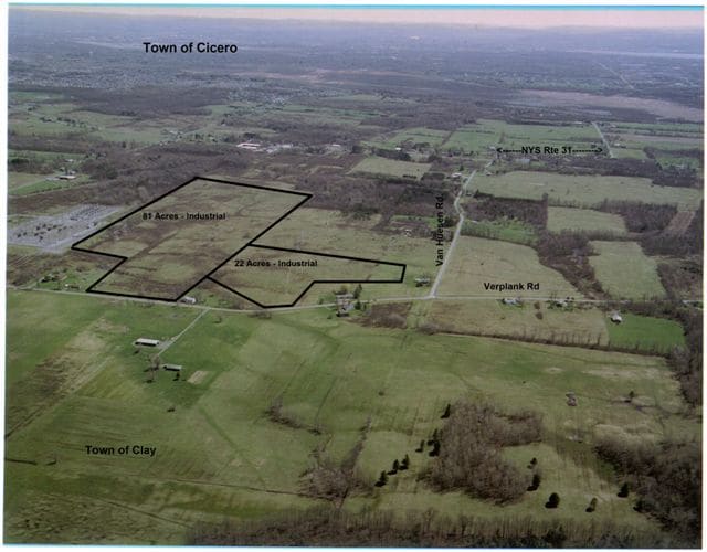
Property Detail
Ver Plank Rd
Syracuse, NY
FL 26 1165866
312489-047-000-0001-007-000-0000
ONONDAGA
Industrialacreage
New York
06 - INDUS
7.000
B and X Area of moderate flood hazard, usually the area between the limits of the 100-year and 500-year floods.
45.22 AC
2025
NE Outer Onondaga County
2024
Syracuse
011241
NEARBY LISTINGS FOR SALE OR LEASE
-
-
-
-
-
-
-
No Photo
-
View all Clay listings for sale on LoopNet.com
DEMOGRAPHICS near Ver Plank Rd
1 mile
3 mile
5 mile
2025 Total Population
277
13,853
69,157
2030 Population
275
13,678
68,432
Pop Growth 2025-2030
(0.72%)
(1.26%)
(1.05%)
Average Age
44
42
42
2025 Total Households
106
5,432
27,999
HH Growth 2025-2030
(0.94%)
(1.33%)
(1.12%)
Median Household Inc
$150,641
$110,616
$99,726
Avg Household Size
2.60
2.50
2.40
2025 Avg HH Vehicles
2.00
2.00
2.00
Median Home Value
$299,999
$250,537
$215,135
Median Year Built
1958
1985
1979
Nearby Places
Map Layers
Map Styles
 Street
 Aerial
Transit
 Traffic
 Biking
Places
Listings with unknown addresses are not visible on the map
- Restaurants
- Banks
- Shops
- Fitness
- Groceries
PUBLIC TRANSPORTATION
AIRPORT
Syracuse Hancock International
Drive
Walk
Distance
Syracuse Hancock International
17 min
10.7 mi
Freight Ports
Albany, NY Port
Drive
Walk
Distance
Albany, NY Port
181 min
151.1 mi
SALE & LEASE HISTORY
LISTING DATE
SALE/LEASE

Sep 24, 2016
For Sale
Mar 31, 2017
For Sale
Nearby Properties
Address
Land Use
TOTAL SIZE
Lot Size
Zoning
Address
Land Use
TOTAL SIZE
Lot Size
Zoning
8,417 SF
13.95 AC
Address
Land Use
TOTAL SIZE
Lot Size
Zoning
1,568 SF
330.36 AC
Address
Land Use
TOTAL SIZE
Lot Size
Zoning
39,128 SF
17.22 AC
Address
Land Use
TOTAL SIZE
Lot Size
Zoning
17,436 SF
98.89 AC
06000
Address
Land Use
TOTAL SIZE
Lot Size
Zoning
16,630 SF
10.16 AC
Address
Land Use
TOTAL SIZE
Lot Size
Zoning
51,587 SF
10.37 AC
Address
Land Use
TOTAL SIZE
Lot Size
Zoning
116,020 SF
15.72 AC
PUD
Address
Land Use
TOTAL SIZE
Lot Size
Zoning
39,591 SF
7.39 AC
Address
Land Use
TOTAL SIZE
Lot Size
Zoning
11.96 AC
Address
Land Use
TOTAL SIZE
Lot Size
Zoning
42,210 SF
62.23 AC
N00
Address
Land Use
TOTAL SIZE
Lot Size
Zoning
16,630 SF
2.66 AC
Address
Land Use
TOTAL SIZE
Lot Size
Zoning
16,630 SF
3.95 AC
Address
Land Use
TOTAL SIZE
Lot Size
Zoning
13,576 SF
1.98 AC
Address
Land Use
TOTAL SIZE
Lot Size
Zoning
13,576 SF
1.98 AC
Address
Land Use
TOTAL SIZE
Lot Size
Zoning
17,760 SF
4.54 AC
CG
Address
Land Use
TOTAL SIZE
Lot Size
Zoning
12,978 SF
1.76 AC
PUD-R
Address
Land Use
TOTAL SIZE
Lot Size
Zoning
8,068 SF
3.33 AC
Address
Land Use
TOTAL SIZE
Lot Size
Zoning
2,314 SF
96.17 AC
06000
Address
Land Use
TOTAL SIZE
Lot Size
Zoning
12,585 SF
6.58 AC
Address
Land Use
TOTAL SIZE
Lot Size
Zoning
21,224 SF
3 AC
CG
Address
Land Use
TOTAL SIZE
Lot Size
Zoning
5,625 SF
1.37 AC
Address
Land Use
TOTAL SIZE
Lot Size
Zoning
51,294 SF
6.25 AC
Address
Land Use
TOTAL SIZE
Lot Size
Zoning
10,540 SF
4.59 AC
CG
Address
Land Use
TOTAL SIZE
Lot Size
Zoning
6,200 SF
117.28 AC
06 - INDUS
Address
Land Use
TOTAL SIZE
Lot Size
Zoning
Address
Land Use
TOTAL SIZE
Lot Size
Zoning
13,844 SF
3.49 AC
Address
Land Use
TOTAL SIZE
Lot Size
Zoning
7,200 SF
71.08 AC
Address
Land Use
TOTAL SIZE
Lot Size
Zoning
12,312 SF
40.32 AC
05 - COMME
Address
Land Use
TOTAL SIZE
Lot Size
Zoning
54,523 SF
4.72 AC
Address
Land Use
TOTAL SIZE
Lot Size
Zoning
864 SF
98.47 AC
01 - NOT Z
The World's #1 Commercial Real Estate Marketplace
Connect with us
© 2026 CoStar Group
The information above has been obtained from sources believed reliable. While we do not doubt its accuracy we have not verified it and make no guarantee, warranty or representation about it. It is your responsibility to independently confirm its accuracy and completeness. Any projections, opinions, assumptions, or estimates used are for example only and do not represent the current or future performance of the property. The value of this transaction to you depends on tax and other factors which should be evaluated by your tax, financial, and legal advisors. You and your advisors should conduct a careful, independent investigation of the property to determine to your satisfaction the suitability of the property for your needs.