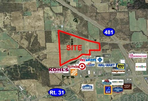
Property Record
Ver Plank Rd, Liverpool, NY 13090
NEARBY LISTINGS FOR SALE OR LEASE
Property Detail
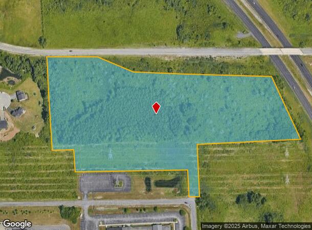
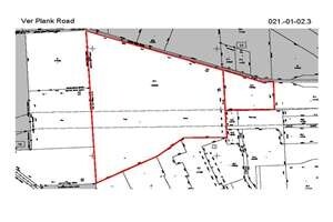
Ver Plank Rd
Syracuse, NY
Wegmans
312489-021-000-0001-004-001-0000
WEGMANS SEC 4 LT 3 1163092
Agriculturalland
Onondaga
X
New York
36067C0078F
4.001
2025
15.21 AC
2024
NE Outer Onondaga County
011101
Syracuse
DEMOGRAPHICS near Ver Plank Rd
1 Mile
3 Mile
5 Mile
2024 Total Population
2,360
26,762
58,499
2029 Population
2,345
26,096
57,087
Pop Growth 2024-2029
(0.64%)
(2.49%)
(2.41%)
Average Age
41
42
42
2024 Total Households
1,145
10,983
24,016
HH Growth 2024-2029
(0.87%)
(2.67%)
(2.59%)
Median Household Inc
$70,961
$83,463
$80,967
Avg Household Size
2.00
2.40
2.40
2024 Avg HH Vehicles
2.00
2.00
2.00
Median Home Value
$230,099
$202,020
$188,245
Median Year Built
2003
1985
1980
Nearby Places
- Restaurants
- Banks
- Shops
- Fitness
- Groceries
PUBLIC TRANSPORTATION
AIRPORT
Syracuse Hancock International
DRIVE
WALK
Distance
Syracuse Hancock International
21 min
13.5 mi
Freight Ports
Albany, NY Port
DRIVE
WALK
Distance
Albany, NY Port
184 min
153.5 mi
Nearby Properties
Address
Land Use
TOTAL SIZE
Lot Size
Zoning
Address
Land Use
TOTAL SIZE
Lot Size
Zoning
99,442 SF
11.75 AC
PUD
Address
Land Use
TOTAL SIZE
Lot Size
Zoning
28,800 SF
6.86 AC
R40
Address
Land Use
TOTAL SIZE
Lot Size
Zoning
2,520 SF
16.28 AC
FED
Address
Land Use
TOTAL SIZE
Lot Size
Zoning
28,800 SF
4.72 AC
PUD
Address
Land Use
TOTAL SIZE
Lot Size
Zoning
28,800 SF
3.19 AC
PUD
Address
Land Use
TOTAL SIZE
Lot Size
Zoning
10,330 SF
241.94 AC
PUD
Address
Land Use
TOTAL SIZE
Lot Size
Zoning
6,528 SF
27.74 AC
PUD
Address
Land Use
TOTAL SIZE
Lot Size
Zoning
2,920 SF
13.70 AC
PUD
Address
Land Use
TOTAL SIZE
Lot Size
Zoning
6,724 SF
10.05 AC
PUD
Address
Land Use
TOTAL SIZE
Lot Size
Zoning
17,628 SF
2.76 AC
PUD
Address
Land Use
TOTAL SIZE
Lot Size
Zoning
5,371 SF
154.56 AC
PUD
Address
Land Use
TOTAL SIZE
Lot Size
Zoning
65,320 SF
12.97 AC
C-1
Address
Land Use
TOTAL SIZE
Lot Size
Zoning
12,312 SF
40.32 AC
05 - COMME
Address
Land Use
TOTAL SIZE
Lot Size
Zoning
6,880 SF
2.03 AC
C-1
Address
Land Use
TOTAL SIZE
Lot Size
Zoning
62,496 SF
26.34 AC
04 - FARM
Address
Land Use
TOTAL SIZE
Lot Size
Zoning
5,736 SF
1.08 AC
PUD
Address
Land Use
TOTAL SIZE
Lot Size
Zoning
4,428 SF
58.31 AC
Address
Land Use
TOTAL SIZE
Lot Size
Zoning
3,776 SF
1.50 AC
MR
Address
Land Use
TOTAL SIZE
Lot Size
Zoning
7,780 SF
1.19 AC
PUD
Address
Land Use
TOTAL SIZE
Lot Size
Zoning
12.90 AC
R-1
Address
Land Use
TOTAL SIZE
Lot Size
Zoning
231.08 AC
R40
Address
Land Use
TOTAL SIZE
Lot Size
Zoning
74,012 SF
58.67 AC
04 - FARM
Address
Land Use
TOTAL SIZE
Lot Size
Zoning
7,350 SF
128.54 AC
02 - SINGL
Address
Land Use
TOTAL SIZE
Lot Size
Zoning
4,346 SF
1.09 AC
PUD
Address
Land Use
TOTAL SIZE
Lot Size
Zoning
720 SF
5.49 AC
RMH-1
Address
Land Use
TOTAL SIZE
Lot Size
Zoning
1,800 SF
24 AC
I
Address
Land Use
TOTAL SIZE
Lot Size
Zoning
183,715 SF
18.21 AC
05 - COMME
Address
Land Use
TOTAL SIZE
Lot Size
Zoning
12,500 SF
3.31 AC
C-1
Address
Land Use
TOTAL SIZE
Lot Size
Zoning
75,000 SF
14.90 AC
04
Address
Land Use
TOTAL SIZE
Lot Size
Zoning
22.10 AC
PUD
The World's #1 Commercial Real Estate Marketplace
Connect with us
© 2025 CoStar Group
The information above has been obtained from sources believed reliable. While we do not doubt its accuracy we have not verified it and make no guarantee, warranty or representation about it. It is your responsibility to independently confirm its accuracy and completeness. Any projections, opinions, assumptions, or estimates used are for example only and do not represent the current or future performance of the property. The value of this transaction to you depends on tax and other factors which should be evaluated by your tax, financial, and legal advisors. You and your advisors should conduct a careful, independent investigation of the property to determine to your satisfaction the suitability of the property for your needs.