Property Record
0 Near Veterans Memorial Dr, Houston, TX 77038
NEARBY LISTINGS FOR SALE OR LEASE
-
-
-
-
-
-
No Photo
-
-
View all Houston listings for sale on LoopNet.com
Property Detail
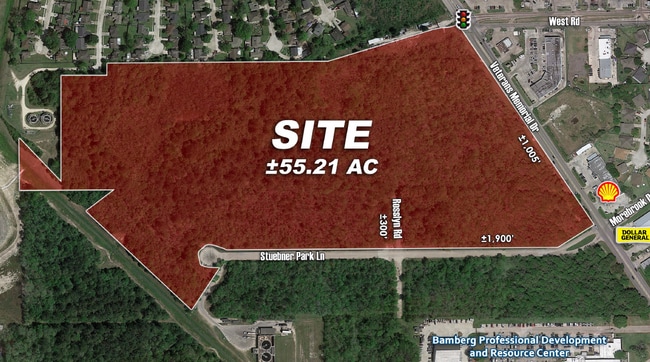
0 Near Veterans Memorial Dr
Houston-The Woodlands-Sugar Land, TX
Charleston Gardens
0092160100004
LTS 4 & 5 BLK 10 CHARLESTON GARDENS
Commercialacreage
Harris
AE
Texas
48201C0465M
4,5
0
17.60 AC
2025
Northwest Far
533702
Houston
DEMOGRAPHICS near 0 Near Veterans Memorial Dr
1 Mile
3 Mile
5 Mile
2024 Total Population
14,491
114,351
330,676
2029 Population
14,581
115,729
335,419
Pop Growth 2024-2029
+ 0.62%
+ 1.21%
+ 1.43%
Average Age
34
35
34
2024 Total Households
3,959
34,269
104,084
HH Growth 2024-2029
+ 0.68%
+ 1.23%
+ 1.48%
Median Household Inc
$52,830
$43,296
$42,630
Avg Household Size
3.60
3.30
3.10
2024 Avg HH Vehicles
2.00
2.00
2.00
Median Home Value
$155,551
$154,714
$159,797
Median Year Built
1987
1980
1982
Nearby Places
Map Layers
Map Styles
 Street
 Aerial
- Restaurants
- Banks
- Shops
- Fitness
- Groceries
PUBLIC TRANSPORTATION
AIRPORT
George Bush Intcntl/Houston
DRIVE
WALK
Distance
George Bush Intcntl/Houston
18 min
11.9 mi
William P Hobby
DRIVE
WALK
Distance
William P Hobby
40 min
24.9 mi
Freight Ports
Port of Houston
DRIVE
WALK
Distance
Port of Houston
32 min
20.4 mi
SALE & LEASE HISTORY
LISTING DATE
SALE/LEASE

Sep 25, 2016
For Lease
Apr 10, 2024
For Sale
Nearby Properties
Address
Land Use
TOTAL SIZE
Lot Size
Zoning
Address
Land Use
TOTAL SIZE
Lot Size
Zoning
858,420 SF
60.71 AC
Address
Land Use
TOTAL SIZE
Lot Size
Zoning
145.62 AC
Address
Land Use
TOTAL SIZE
Lot Size
Zoning
739,141 SF
54 AC
Address
Land Use
TOTAL SIZE
Lot Size
Zoning
413,178 SF
21.45 AC
Address
Land Use
TOTAL SIZE
Lot Size
Zoning
614,256 SF
31.25 AC
Address
Land Use
TOTAL SIZE
Lot Size
Zoning
608,784 SF
29.08 AC
Address
Land Use
TOTAL SIZE
Lot Size
Zoning
718,600 SF
42.09 AC
Address
Land Use
TOTAL SIZE
Lot Size
Zoning
504,000 SF
32.25 AC
Address
Land Use
TOTAL SIZE
Lot Size
Zoning
424,122 SF
21.06 AC
Address
Land Use
TOTAL SIZE
Lot Size
Zoning
356,900 SF
19.38 AC
Address
Land Use
TOTAL SIZE
Lot Size
Zoning
350,500 SF
17.71 AC
Address
Land Use
TOTAL SIZE
Lot Size
Zoning
125,512 SF
18.26 AC
Address
Land Use
TOTAL SIZE
Lot Size
Zoning
284,476 SF
20 AC
Address
Land Use
TOTAL SIZE
Lot Size
Zoning
284,687 SF
19.66 AC
Address
Land Use
TOTAL SIZE
Lot Size
Zoning
292,112 SF
4.41 AC
Address
Land Use
TOTAL SIZE
Lot Size
Zoning
200,123 SF
14.94 AC
Address
Land Use
TOTAL SIZE
Lot Size
Zoning
383,451 SF
15.98 AC
Address
Land Use
TOTAL SIZE
Lot Size
Zoning
240,240 SF
14.35 AC
Address
Land Use
TOTAL SIZE
Lot Size
Zoning
244,864 SF
12.30 AC
Address
Land Use
TOTAL SIZE
Lot Size
Zoning
244,760 SF
17.20 AC
Address
Land Use
TOTAL SIZE
Lot Size
Zoning
202,362 SF
8.02 AC
Address
Land Use
TOTAL SIZE
Lot Size
Zoning
261,000 SF
13.89 AC
Address
Land Use
TOTAL SIZE
Lot Size
Zoning
319,231 SF
14.97 AC
Address
Land Use
TOTAL SIZE
Lot Size
Zoning
318,135 SF
14.11 AC
Address
Land Use
TOTAL SIZE
Lot Size
Zoning
250,660 SF
14.22 AC
Address
Land Use
TOTAL SIZE
Lot Size
Zoning
213,200 SF
18.72 AC
Address
Land Use
TOTAL SIZE
Lot Size
Zoning
193,972 SF
14.59 AC
Address
Land Use
TOTAL SIZE
Lot Size
Zoning
221,810 SF
13.96 AC
Address
Land Use
TOTAL SIZE
Lot Size
Zoning
218,734 SF
11.24 AC
Address
Land Use
TOTAL SIZE
Lot Size
Zoning
201,292 SF
7.67 AC
The World's #1 Commercial Real Estate Marketplace
Connect with us
© 2025 CoStar Group
The information above has been obtained from sources believed reliable. While we do not doubt its accuracy we have not verified it and make no guarantee, warranty or representation about it. It is your responsibility to independently confirm its accuracy and completeness. Any projections, opinions, assumptions, or estimates used are for example only and do not represent the current or future performance of the property. The value of this transaction to you depends on tax and other factors which should be evaluated by your tax, financial, and legal advisors. You and your advisors should conduct a careful, independent investigation of the property to determine to your satisfaction the suitability of the property for your needs.