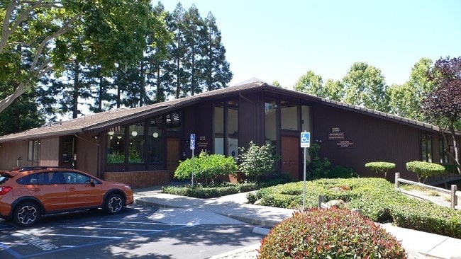
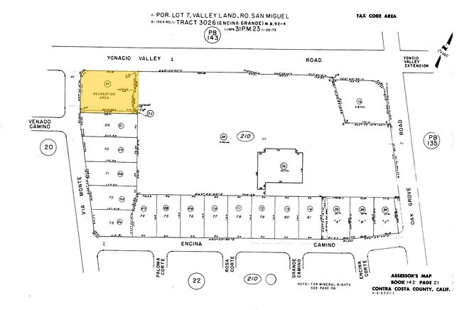
Property Record
Via Monte, Walnut Creek, CA 94598
Save to a Folder
{{folder.Name}}
{{folder.ListingIds.length}} Properties
{{folder.ListingIds.length}} Property
Create a New Folder
Property Detail
Via Monte
Oakland-Fremont-Berkeley, CA
TRACT 3026 POR REC AREA EX MR
142-210-022-0
CONTRA COSTA
Commercialnec
California
B and X Area of moderate flood hazard, usually the area between the limits of the 100-year and 500-year floods.
0.05 AC
2025
Walnut Creek-BART/DT
2026
East Bay/Oakland
338301
NEARBY LISTINGS FOR SALE OR LEASE
DEMOGRAPHICS near Via Monte
1 mile
3 mile
5 mile
2025 Total Population
11,478
114,712
265,751
2030 Population
11,611
115,820
267,943
Pop Growth 2025-2030
+ 1.16%
+ 0.97%
+ 0.82%
Average Age
45
42
43
2025 Total Households
4,174
45,605
104,787
HH Growth 2025-2030
+ 1.27%
+ 1.17%
+ 0.95%
Median Household Inc
$186,194
$135,036
$131,417
Avg Household Size
2.70
2.50
2.50
2025 Avg HH Vehicles
2.00
2.00
2.00
Median Home Value
$1,113,919
$948,713
$927,137
Median Year Built
1968
1974
1972
Nearby Places
Map Layers
Map Styles
 Street
 Aerial
Layers
 Traffic
 Biking
Places
Listings with unknown addresses are not visible on the map
- Restaurants
- Banks
- Shops
- Fitness
- Groceries
PUBLIC TRANSPORTATION
AIRPORT
Metro Oakland International
Drive
Walk
Distance
Metro Oakland International
40 min
27.6 mi
San Francisco International
Drive
Walk
Distance
San Francisco International
58 min
39.5 mi
Freight Ports
Port of Oakland
Drive
Walk
Distance
Port of Oakland
30 min
20.4 mi
SALE & LEASE HISTORY
LISTING DATE
SALE/LEASE

Jul 07, 2017
For Sale
Nearby Properties
Address
Land Use
TOTAL SIZE
Lot Size
Zoning
Address
Land Use
TOTAL SIZE
Lot Size
Zoning
Address
Land Use
TOTAL SIZE
Lot Size
Zoning
Address
Land Use
TOTAL SIZE
Lot Size
Zoning
155,176 SF
3.34 AC
Address
Land Use
TOTAL SIZE
Lot Size
Zoning
295,561 SF
3.80 AC
Address
Land Use
TOTAL SIZE
Lot Size
Zoning
337,980 SF
5.08 AC
Address
Land Use
TOTAL SIZE
Lot Size
Zoning
254,940 SF
1.61 AC
P1
Address
Land Use
TOTAL SIZE
Lot Size
Zoning
264,873 SF
2.19 AC
P1
Address
Land Use
TOTAL SIZE
Lot Size
Zoning
203,454 SF
2.33 AC
Address
Land Use
TOTAL SIZE
Lot Size
Zoning
5.52 AC
P1
Address
Land Use
TOTAL SIZE
Lot Size
Zoning
235,495 SF
2.51 AC
P1
Address
Land Use
TOTAL SIZE
Lot Size
Zoning
250,032 SF
7.95 AC
P1
Address
Land Use
TOTAL SIZE
Lot Size
Zoning
393,680 SF
2.29 AC
Address
Land Use
TOTAL SIZE
Lot Size
Zoning
249,628 SF
3.64 AC
P1
Address
Land Use
TOTAL SIZE
Lot Size
Zoning
157,352 SF
0.98 AC
Address
Land Use
TOTAL SIZE
Lot Size
Zoning
118,596 SF
1.20 AC
Address
Land Use
TOTAL SIZE
Lot Size
Zoning
192,387 SF
17.42 AC
M17
Address
Land Use
TOTAL SIZE
Lot Size
Zoning
187,156 SF
5.92 AC
P1
Address
Land Use
TOTAL SIZE
Lot Size
Zoning
12,864 SF
5.62 AC
Address
Land Use
TOTAL SIZE
Lot Size
Zoning
237,656 SF
7.16 AC
P1
Address
Land Use
TOTAL SIZE
Lot Size
Zoning
239,182 SF
3.61 AC
Address
Land Use
TOTAL SIZE
Lot Size
Zoning
166,144 SF
19.22 AC
Address
Land Use
TOTAL SIZE
Lot Size
Zoning
164,517 SF
3.65 AC
Address
Land Use
TOTAL SIZE
Lot Size
Zoning
109,261 SF
1.33 AC
Address
Land Use
TOTAL SIZE
Lot Size
Zoning
76,662 SF
1.37 AC
Address
Land Use
TOTAL SIZE
Lot Size
Zoning
148,140 SF
4.28 AC
P1
Address
Land Use
TOTAL SIZE
Lot Size
Zoning
80,813 SF
8.08 AC
Address
Land Use
TOTAL SIZE
Lot Size
Zoning
3,036 SF
11.11 AC
Address
Land Use
TOTAL SIZE
Lot Size
Zoning
22,152 SF
5.51 AC
Address
Land Use
TOTAL SIZE
Lot Size
Zoning
12,770 SF
1.24 AC
Address
Land Use
TOTAL SIZE
Lot Size
Zoning
22,999 SF
7.14 AC
The World's #1 Commercial Real Estate Marketplace
Connect with us
© 2026 CoStar Group
The information above has been obtained from sources believed reliable. While we do not doubt its accuracy we have not verified it and make no guarantee, warranty or representation about it. It is your responsibility to independently confirm its accuracy and completeness. Any projections, opinions, assumptions, or estimates used are for example only and do not represent the current or future performance of the property. The value of this transaction to you depends on tax and other factors which should be evaluated by your tax, financial, and legal advisors. You and your advisors should conduct a careful, independent investigation of the property to determine to your satisfaction the suitability of the property for your needs.