Property Record
Vickers Rd, Fairburn, GA 30213

Property Detail
Vickers Rd
09F-1701-0074-235-8
AN VACANT 01
Residentialacreage
FULTON
R1
Georgia
B and X Area of moderate flood hazard, usually the area between the limits of the 100-year and 500-year floods.
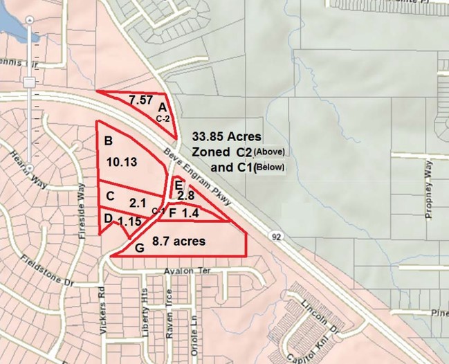
2.10 AC
2024
North Clayton/Airport
2025
Atlanta
010535
Atlanta-Sandy Springs-Roswell, GA
NEARBY LISTINGS FOR SALE OR LEASE
DEMOGRAPHICS near Vickers Rd
1 mile
3 mile
5 mile
2025 Total Population
5,694
40,857
97,291
2030 Population
5,869
42,065
100,395
Pop Growth 2025-2030
+ 3.07%
+ 2.96%
+ 3.19%
Average Age
37
37
38
2025 Total Households
1,948
15,106
35,591
HH Growth 2025-2030
+ 3.03%
+ 2.91%
+ 3.10%
Median Household Inc
$62,955
$77,560
$82,617
Avg Household Size
2.90
2.60
2.70
2025 Avg HH Vehicles
2.00
2.00
2.00
Median Home Value
$280,777
$294,011
$307,145
Median Year Built
2002
2003
2003
Nearby Places
Map Layers
Map Styles
 Street
 Aerial
Transit
 Traffic
 Biking
Places
Listings with unknown addresses are not visible on the map
- Restaurants
- Banks
- Shops
- Fitness
- Groceries
PUBLIC TRANSPORTATION
AIRPORT
Hartsfield - Jackson Atlanta International
Drive
Walk
Distance
Hartsfield - Jackson Atlanta International
23 min
14.0 mi
SALE & LEASE HISTORY
LISTING DATE
SALE/LEASE

Sep 24, 2016
For Sale
Feb 27, 2019
For Sale
Nearby Properties
Address
Land Use
TOTAL SIZE
Lot Size
Zoning
Address
Land Use
TOTAL SIZE
Lot Size
Zoning
1,511,212 SF
19.33 AC
M1
Address
Land Use
TOTAL SIZE
Lot Size
Zoning
11.10 AC
SUBC
Address
Land Use
TOTAL SIZE
Lot Size
Zoning
74.44 AC
Address
Land Use
TOTAL SIZE
Lot Size
Zoning
595,060 SF
62.71 AC
Address
Land Use
TOTAL SIZE
Lot Size
Zoning
1,020,000 SF
59.94 AC
Address
Land Use
TOTAL SIZE
Lot Size
Zoning
1,102,504 SF
24.79 AC
A
Address
Land Use
TOTAL SIZE
Lot Size
Zoning
78.33 AC
Address
Land Use
TOTAL SIZE
Lot Size
Zoning
1,776,355 SF
13.40 AC
PD
Address
Land Use
TOTAL SIZE
Lot Size
Zoning
1,040,000 SF
74.64 AC
AG1
Address
Land Use
TOTAL SIZE
Lot Size
Zoning
831,160 SF
17.53 AC
C2
Address
Land Use
TOTAL SIZE
Lot Size
Zoning
873,600 SF
65.24 AC
C2
Address
Land Use
TOTAL SIZE
Lot Size
Zoning
798,272 SF
18.32 AC
M1A
Address
Land Use
TOTAL SIZE
Lot Size
Zoning
744,000 SF
60.69 AC
GC
Address
Land Use
TOTAL SIZE
Lot Size
Zoning
1,873,575 SF
50.47 AC
RM
Address
Land Use
TOTAL SIZE
Lot Size
Zoning
39.08 AC
SUBC
Address
Land Use
TOTAL SIZE
Lot Size
Zoning
130,516 SF
6.50 AC
C1
Address
Land Use
TOTAL SIZE
Lot Size
Zoning
1,050,936 SF
26.33 AC
C1
Address
Land Use
TOTAL SIZE
Lot Size
Zoning
247,088 SF
20.90 AC
Address
Land Use
TOTAL SIZE
Lot Size
Zoning
384,305 SF
15.26 AC
MIX
Address
Land Use
TOTAL SIZE
Lot Size
Zoning
567,000 SF
41.83 AC
AG1
Address
Land Use
TOTAL SIZE
Lot Size
Zoning
498,274 SF
24.34 AC
MIA
Address
Land Use
TOTAL SIZE
Lot Size
Zoning
491,992 SF
48.25 AC
M1
Address
Land Use
TOTAL SIZE
Lot Size
Zoning
499,950 SF
63.40 AC
AG1
Address
Land Use
TOTAL SIZE
Lot Size
Zoning
420,000 SF
23.69 AC
MIA
Address
Land Use
TOTAL SIZE
Lot Size
Zoning
31.58 AC
Address
Land Use
TOTAL SIZE
Lot Size
Zoning
1,320,344 SF
0.35 AC
MIX
Address
Land Use
TOTAL SIZE
Lot Size
Zoning
661,312 SF
11.40 AC
RM
Address
Land Use
TOTAL SIZE
Lot Size
Zoning
1,466,922 SF
21.58 AC
C1
Address
Land Use
TOTAL SIZE
Lot Size
Zoning
2,404,061 SF
20.21 AC
RM
Address
Land Use
TOTAL SIZE
Lot Size
Zoning
23 AC
AG1
The World's #1 Commercial Real Estate Marketplace
Connect with us
© 2026 CoStar Group
The information above has been obtained from sources believed reliable. While we do not doubt its accuracy we have not verified it and make no guarantee, warranty or representation about it. It is your responsibility to independently confirm its accuracy and completeness. Any projections, opinions, assumptions, or estimates used are for example only and do not represent the current or future performance of the property. The value of this transaction to you depends on tax and other factors which should be evaluated by your tax, financial, and legal advisors. You and your advisors should conduct a careful, independent investigation of the property to determine to your satisfaction the suitability of the property for your needs.